Showing posts with label Kerala. Show all posts

Monday, October 10, 2016

Kallil Bhagavathy cave temple: Jain / Buddhist Natural Cave in Methala near Ernakulam, Kerala


Kallil Bhagavathi Temple_Cochin_Kerala.jpg (600×399)
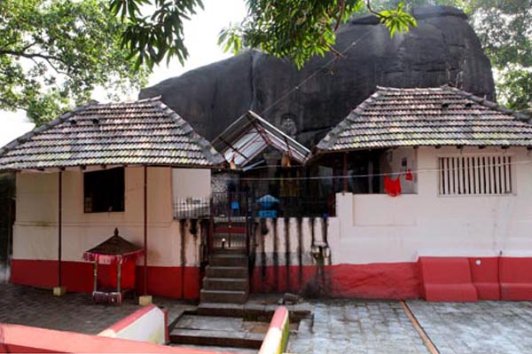
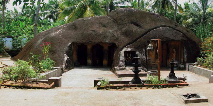
Kallil Bagavathy Temple
84077167-e1407281555469-624x408.jpg (624×408)

P1070095-300x225.jpg (300×225)
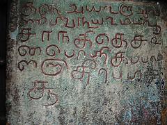
Tirthankara Bas Relief
kallil-temple-jain-saint.jpg (1018×625)
Jain Saint
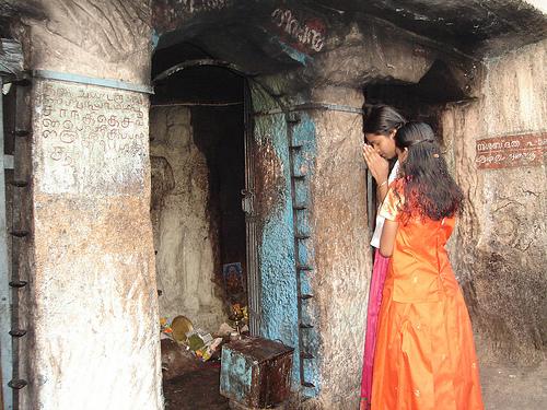
Kallil (കല്ലിൽ) cave temple,  a Jain temple, is located in Methala (മേത്തല) village, Koovappady (കൂവപ്പാടി) taluk, Ernakulam (എറണാകുളം) District, Kerala, India PIN 683545 and forms part of Asamannoor (അശമന്നൂർ) Panchayat. The Methla town in Trissur district should not be confused with this village. The cave temple is located 42 km towards East from district head quarters Ernakulam. 10 km from Koovappady. 22 km away from Kalady (കാലടി) (birth place St. Sankaracharya (ശങ്കരാചാര്യാ), 217 km from state capital Thiruvananthapuram. Kallil means 'in stone' in Malayalam language. The geographical coordinates of Mathala are 10.112921°N Lattitude and 76.5517132°E Longitude. The altitude / elevation is 30 m (100 feet). According to the 2011 census of India, Asamannoor has 4714 households and the population is 19311 (Male 9574, Female 9737) . The literacy rate of the village is 84.57%. The temple is owned by the Kallil Pisharody (കല്ലിൽ പിഷാരോടി) family. The overall administrative control of the temple remains with the present Karanavar (കാരണവർ) of the family and all its properties maintained by 'Chenkottukonam Sree Ramadasashramam' (സെൻകോട്ടുക്കോണം  ശ്രീ രാമദാസ് ആശ്രമം). But all that retrieved back due to some hassle between local people and Ashram authorities. The monument is protected by Archaeological Survey of India (ASI).

Kallil Bhagavathy in Natural Cave

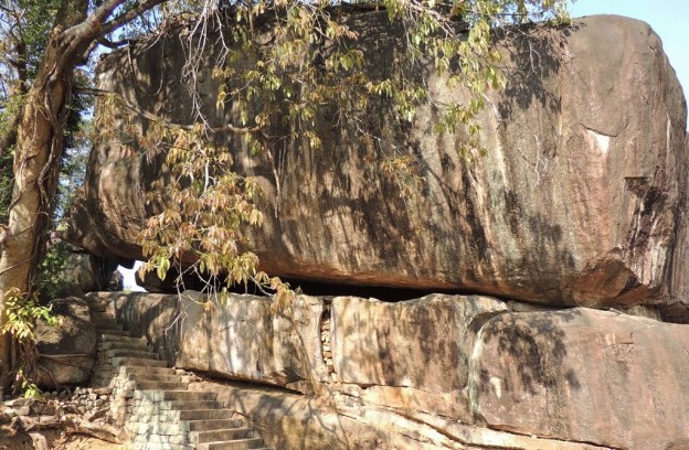
Kallil Bhagavathy (കല്ലിൽ ഭഗവതി), is natural cavern where legend, myth and history meet. It is considered one among prime ancient Jain temples in Kerala. It is located right in the middle of a jungle and it is as wide as 28 acres,  It is located beneath the huge monolith rock measuring a 75 feet in length, 45 feet in width and 25 feet in height and it stands sans the support on the ground. The flight of 120 steps leads to the cave temple. It is believed that the inception of the temple might date back to third century B.C.. Scholars also agree with this theory. The Jain cave temple is now converted and dedicated to Bhagavathy (a ferocious form of Mahishasurmardini i.e., form of Shakti). Bhagavathy is the prime deity of this cave temple.
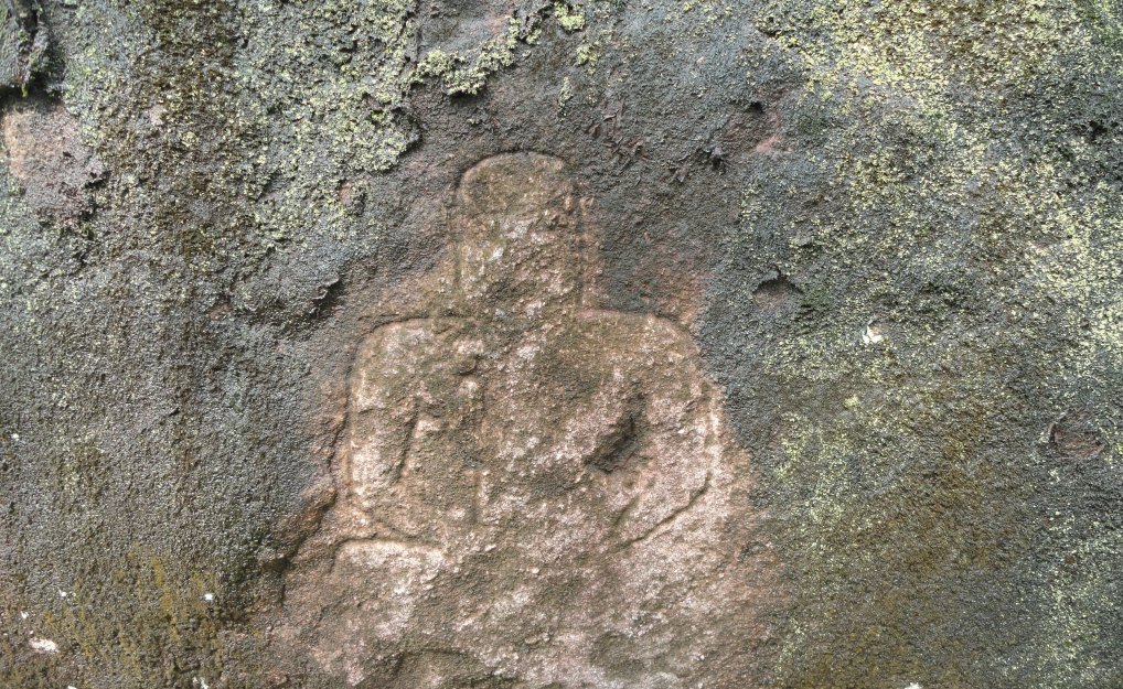
Jain Images

The bas relief image of Lord Brahma is sculpted on top of the rock. It is believed that the rock is standing stable on its position due to the grace of Bhagavathy. The cave temple also houses images of Parshvanatha (also known as Parshva),  the twenty-third Tirthankara and Mahavira, (also known as Vardhamāna),  the twenty-fourth and last Jain Tirthankara and Padmāvatī the protective goddess or shashan devi of Lord Parshvanatha. The Jain monks might have frequented this cave and performed religious practices.

Bhagavathy Cult

The worship of Bhagavathi is popular and widespread in Kerala, Goa and Konkan. The Bhagavathi worship is also a part of Theyyam (Theyyattam ) (തെയ്യം) (spirit) worship, a popular ritual form of worship of North Malabar in Kerala. The term theyyam is a corrupt form of Dhaivam or God. It is also popular ritual art form of northern Kerala especially prevalent in the traditional Kolathunadu (the present Kannur and Kasargod Districts). Keralopathy, the popular historical book cites about the sanctioning of the festival such as Kaliyattam (i.e., Theyyattam or Daivattam) by Saint. Parasurama to the Keralites. The responsibility of performing Theyyam dance is assigned, by the saint, with the indigenous communities like Panan, Velan, Vannan and Malayan and Velan.

Theyyam Communities and Tamil Sangam Dance Traditions

Theyyam dancers are referred to in the sangam literature. The dancer, as per Sangam tradition, was "employed by the mothers of love born girls to exercise the malignant spirits from their daughters." The rituals of Sangam tradition described in Tamil Sangam literature (including Sangam commentaries are being totally observed by Velan and other dancing traditions. The Sangam literature describes Ezhimalai, the hilly region ruled by Udayan Venmon Nannan. It is believed that Ezhimalai region is now known as the present Kolathunadu near Payyannur. Hence it is believed that the Tamil Sangam Age cult still continues with regional variations.

Tantric Vajrayana Buddhism Vs Brahminical Hinduism in Kerala

Until the medieval period the people were almost Buddhists in mid and south Kerala. It will be surprising to learn that most of the popular Hindu temples in Kerala including Vaikam were originally Mahayana shrines and Buddhist Viharas, nunneries and monasteries. It is believed that Mahayana Boddhisatva idols are converted to gods Hindu pantheon i.e, Muruga, Ayyappa and Kuttikrishna in caste Hindnu temples. The Vajrayana Siddhas and Tara Devis began to be increasingly called as Tozhuvans and Hindu Bhagavatis in the post middle ages. Tara Devi turned from Buddhist Vajrayana Siddhi to Bhagavathi (Durga). In the 16th century Chennas wrote Tantra Samuchayam and absorbed the Tantric Buddhist deities into the Tantric Brahmanic mode, eventually completing the take over. The scholars believe that Tantric Vajrayana (tantric corpus of Buddhism) practice within the Buddhism might have led to Bhagavathy cult. Since Buddhism wiped out in Kerala i.e., in the dominant matriarchial setting, the Tara cult might have transformed into Sakthi cult and Spirit worship.

Untouchability and Class Struggle of Avaranas in Kerala

The Brahmanical Hinduism preached Varna (caste) system and the untouchability practice was enforced on the Avarnas including the current Scheduled Castes and Other Backward Classes between the 8th and 12th century in Kerala. The Avaranas were prohibited from walking on the roads surrounding the temple.  The cast Hindus (Brahminical Hinduism) might have enforced untouchability out of fear over Avaranas (original Buddhists who owned the temple i.e., Buddhist Viharas, nunneries and monasteries) and if Avaranas are permitted to access into the Hindu temples, they might recapture their own Buddhist Viharas, nunneries and monasteries.

Pooja Rituals

Daily Poojas are performed to the deity as per Kerala Agamas. The temple remin closed after midday (noon) and no poojas after sunset.

Festival

The annual festival of this temple is conducted for eight days commencing from the 'Karthika day' in Vrischikam month or Karthikai month (November–December). The idol is taken around on a female elephant for procession.

How to get there?

By Road: To reach the temple one has to travel a distance of about 2 km from Odakkali, on the Aluva Munnar Road and 10 km from Perumbavoor. Perumbavoor is the nearest town.
Nearest Railway station: There is no railway station near to Methala in less than 10 km. How ever Alwaye Rail Way Station is major railway station 22 km near to Methala 
Nearest Airport: Cochin Airport – 25 km


Reference


  1. Buddhism in Kerala. Ayaysekhar Margins January 3rd, 2010 (http://ajaysekher.net/2010/01/03/buddhism-kerala/)
  2. Dalava Kulam Massacre: Caste Killing in 19th Century Kerala Ajaysekhar in Margins . September 28, 2015 (http://ajaysekher.net/2015/09/28/dalava-kulam-massacre-caste-killing-19th-century-kerala/)
  3. Boddhisatva Idols from Kerala: Modification of Utariya into Sacred Thread and the Problems of Misrepresentation Ajaysekhar in Margins January 27, 2015 (http://ajaysekher.net/2015/01/27/boddhisatva-idols-kerala/) 
  4. Kasargod (http://kasargod.nic.in/profile/theyyam.htm)
  5. Rise and fall of Buddhism in Kerala R Madhavan Nair. The Hindu. February 5, 2012
  6. Siddha of Kayikara: Vajrayana in Kerala. Ayaysekhar Margins January 12th, 2013 (http://ajaysekher.net/2013/01/12/siddha-kayikara-vajrayana-kerala/)
  7. Sree Kallil Bhagavathy Temple, Methala (http://kallilcavetemple.com/about-en.html) 
  8. Tara Buddhism (Wikipedia)
  9. Theyyam (Wikipedia)
  10. Theyyam : A Ritual Art Form of North Kerala. Map of India. April 14, 2015 (http://www.mapsofindia.com/my-india/travel/theyyam-a-ritual-art-form-of-north-kerala)
  11. The Bhagavathi cult. Tulu Research. January 16, 2008.
  12. Vajrayana (Wikipedia)
  13. Vajrayana Buddhism Vis-Ã -vis Hindu Tantricism by Acharya Mahayogi Sridhar Rana Rinpoche (http://www.byomakusuma.org/teachings/VajrayanaBuddhismVisAVisHinduTantricism.aspx)
  14. What wiped the Buddhism traces from Kerala History? History Beta (http://history.stackexchange.com/questions/15191/what-wiped-the-buddhism-traces-from-kerala-history)

        YouTube


        Sunday, October 2, 2016

        Vizhinjam Cave: Hindu Rock cut Cave in Vizhinjam near Tiruvananthapuram, Kerala


        Vizhinjam (വിഴിഞ്ഞം) rock cut cave is located  in Vizhinjam village, Athiyanoor (അതിയന്നൂർ) taluk in Thiruvananthapuram  (തിരുവനന്തപുരം) district, Kerala State, India PIN 695521. The cave is located 14 km towards South from District head quarters Thiruvananthapuram. Vizhinjam is located 2 km from Athiyanoor; 3 km from Kottukal (കൊടുക്കൽ ); and 3 km from Kovalam beach (കോവളം ബീച്). The Latitude and Longitude coordinates in degrees, minutes, seconds decimal and degrees decimal of Vizhinjam is 8°22′45″N (8.3932)  and 76°59′29″E (77.0046) respectively. The elevation / altitude of Vizhinjam is 71 meters above Sea level. As per 2011 Population Census 2011, the village has population 20714 (males 10277 and females 10437) and 5040 families in total The village is also the natural port located close to international shipping routes and it is an international deep-water multi-purpose shipping hub.  Neyyattinkara (നെയ്യാറ്റിന്കര),  Kollankodu (കൊല്ലങ്കോട് ), Nedumangad (നെടുമങ്ങാട്) are the nearby Cities to Vizhinjam.

        Architecture

        The Vizhinjam rock cut cave temple premises, under the maintenance of ASI, is located near Vizhinjam bus-stand. Like the Kilmavilangai and Mahendravadi rock cut caves in Tamil Nadu, Vizhinjam cave is excavated on a small boulder measuring about 3 m (9 feet 10 inches) in height and 3.50 m (11 feet 5 inches) in width. On the eastern face of this outcrop, is carved in a single cell sanctum measuring about 1 m (3 feet 2 inches) east-west in length,  0.70 m (2 feet 3 inches) north-south in width and 1.50 m (4 feet 11 inches) in height. The roof slopes towards east. The rear, south and north walls left unfinished. The single cell sanctum houses a loose sculpture of (east facing) Vinadhara Dakshinamurthy (an aspect of Lord Shiva as a guru (teacher) of all types of knowledge and the great teacher of music) of later period.

        There are two plain square pilasters (door frames) cut on either side of the sanctum entrance. The pilasters directly supports the prastara component uttira. Towards the south and north of the pilasters there are two rock cut niches housing bas relief images. The right side niche (formed without pilasters) houses the sthanaka Shiva accompanied by two dwarf images on either side. Shiva appear standing on his right foot planted on the even floor (Sthitha paadam) and the bent (folded) left foot firmly stamping upon the head of the demon "Muyalagan". The demon Muyalagan appear seated on two squatted legs. His left hand holds the bow. A roughly sculpted dwarf gana appears on the left side of Muyalagan. 

        Lord Shiva drapes a piece of loin cloth (A loincloth is a long piece of cloth, passed between the thighs and wound around the waist) and knotted waist cloth. Shiva appears with two arms and the left forearm holds the tall bow; the upper left hand holds ‘mazhu’ (the axe); the right fore arm holds the arrow while the upper right  hand in ardhapathaka (mudra) gesture. The jatamakuta is the hair dress with head band (நெற்றிப்பட்டம்).  The lord wears sarapali around his neck.and the Yagnopavita is worn in niveda fashion. He also wears a palm-leaf coil as ear-ring at his left ear lobe and the right ear lobe locked with kundala.

        The left side niche (formed without pilasters) houses the two bas relief images. The right side male image appears in dancing posture and his left leg is held in parsvatha posture while his right leg held in swastika posture. The face is tilted towards his right side. The lord wears conical jatamakuta. The left ear lobe is adorned with palm-leaf coil as ear-ring. The ankle is adorned with beaded chain.

        The left side female image rests her left hand on her hip and the right hand rests on her chin. The waist cloth tied with knots. The left leg is damaged and the right leg plated on the floor. The identity of these two images could not be established clearly.  

        History

        In the words of Ptolemy the territory of Ay (ஆய்) flourished in the south of the Chera kingdom and extended from Nelcynda to Kumari and the Pandya kingdom lay only 'past Komaria.' According to Robert Sewell Ayes were the rulers of the hill country. Chera dynasty established themselves in major portions of Chera land (present northern Kerala) as the vital force only after Ay dynasty (ஆய் வம்சம்) established themselves around the Potiya hill (பொதியமலை), the southern most section of the Western Ghats. (presently the southern Kerala). So the Ay dynasty  ruled the land between Nagercoil and Thiruvalla and Vizhinjam, the port town, was once the capital of many dynasties including Ay dynasty.  Important Ay rulers are Ay Andiran (ஆய் அண்டிரன்), Titiyan I (முதலாம் திதியன்), Atiyan (அதியன்), Titiyan II (இரண்டாம்  திதியன்) and Nanchil Porunan (நாஞ்சில் பொருநன்). Purananuru (புறநானூறு) extols Ay Andiran as the philanthropic ruler who independent ruled the potiyi hills. He is praised for his patronage as Vel Ay (வேல் ஆய்) and Ma-Vel Ay (மாவேள் ஆய்) by the Sangam poets in Purananuru. Ay Andiran drove Pandyas from his territory and came to prominence around 96 - 140 A.D. Titiyan I was praised as 'Potiyir Selvan' (பொதியிற் செல்வன்). During the time of Atiyan Ay kingdom got disintegrated. It seems that Alakiyapandiyan waged war over Ay kingdom and defeated Atiyan and Ay kingdom was reduced as a tributary of Pandya kingdom. Later the battle between Talayalankanattu Ceru Venra Nedunceliyan Pandya king (தலையாலங்கானத்து செரு வென்ற பாண்டியன் நெடுஞ்செழியன்) and Titiyan II clashed at the historical battle  at Talayalankanam (தலையாலங்கானம்) and sealed the fate of the Ay kingdom. 

        Ay dynasty was later known as Venad (வேள்நாடு / வேணாடு) dynasty and the kingdom located to the south of Chera kingdom. It was later on known as the Tiruvidankur dynasty (திருவிதாங்கூர் வம்சம்).  Karunandadakkan (857-885 AD) (கருணானந்தக்கண்) an illustrious Ay king ruled with his capital at Vizhinjam. His earliest inscription in South India found dated in the Kali era (கலி வருடம்). It throws light on the working of ancient highways (salais) or Vedic colleges. According to the Huzur Office (copper) plates Ay (Vrishni Kula) King Karunandadakkan built the Parthivapuram Parthasarathy Temple (பார்த்திவபுரம் பார்த்தசாரதி கோவில் ) and consecrated in 857 A.D. Vikramaditya Varaguna (885-925) succeeded Karunandadakkan. The Paliyam Copper plate of Vikramaditya Varaguna (885-925) (விக்கிரமாதித்ய வரகுணா) records the grant of an extensive landed property to the Buddhist of Srimulavasa Vihara (ஸ்ரீமூலவாச விஹாரை) by the ruler. The Copper Plates indicates the origin of Ay from Ayars. (Ayars also known as Yadavas). .Ayakkudi (ஆயக்குடி) near Aralvaymoli (ஆரல்வாய்மொழி) gives some idea about Aye kingdom of Sangam age.

        The Chola Empire Parantaka I (907 - 955) Chola (முதலாம் பராந்தக சோழன்) defeated Maravarman Rajasimha (மாறவர்மன் இராஜசிம்ஹன்), the Pandya king and annexed the South Kerala and Nanchil Nadu (Tiruvidankur) during 10th century A.D. The inscriptions of Parantaka I are found in Suchindram.

        This land was also the scene of many battles. In 788 A.D, Jatilavarman Parantaka (Maranjadayan) the Pandya king waged a war over Ay kingdom and encircled Vizhinjam port. The Pandya conquered the Ays and made it a tributary state. Also military campaigns between the Kulasekara rulers (rulers of Venadu) and the later Cholas took place in this region. Vizhinjam also seems to have served as the former Dutch and British factory.

        Temple timings: 0900 - 1800 hrs. It remains closed on Mondays.
        Best Season: October to March

        The Vizhinjam International Transhipment Deep water Multipurpose Seaport is an ambitious project taken up by Government of Kerala. It is designed primarily to cater container transhipment besides multi-purpose and break bulk cargo.

        How to get there?

        Nearest Bus-station: K-S-R-T-C-Vizhinjam-Bus-Station. A good network of roads connect Vizhinjam with several tourist destinations. within Kerala and India. State buses and inter-state buses can be availed to reach Vizhinjam.
        Nearest Railwaystation: Nemem Railway Station , Balabnramapuram Railway Station are the very nearby railway stations to Vizhinjam. How ever Trivandrum Central Railway Station is major railway station 13 KM near to Vizhinjam
        Nearest Airport: Trivandrum International Airport- 14 KM

        Reference 
        1. Archaeological Survey of India. Thrissur Circle. (http://www.asithrissurcircle.in/Monuments.html)
        2. Historical background of Travancore - Shodhganga (PDF)
        3. History of South India – Part 5: Kingdoms of the Sangam Period - The Chera Dynasty. Bharat: An Untold Story. 
        4. Rock cut cave temple, Vizhinjam. Travelogues of a Compulsive Roamer. Saturday, 9, 2014
        5. Vishnu temple of Ay Dynasty. Varnam. February 2, 2005
        6. Vizhinjam Cave Temple. Wikipedia
        7. Vizhinjam in historical perspective. The Hindu July 27. 2015
        8. Vizhinjam Rock Cut Cave Temple. Indian Holiday.com
        9. Vizhinjam Rock Cut Cave, Thiruvananthapuram. Keralatourism.org
        10. விழிஞம் குடைவரைக்கோயில் இரா. கலைக்கோவன் Varalaru.com

        YouTube
        Vizhinjam's cave temple wows tourists by asianetcablevision


        Thursday, September 29, 2016

        Madavoorpara Cave: Hindu Rock cut Temple near Thiruvananthapuram, Kerala


        Madavoor_Para_Cave_Temple.jpg (3600×2160)

        DSC_7231.JPG (1278×855)

        62_big.jpg (500×375)

        51_big.jpg (240×180)

        madavoorpara.jpg (960×1280)

        Madavoorpara rock-cut cave temple is situated in Madavoopara village, Kazhakuttam taluk, Thiruvananthapuram district, Kerala, India PIN 695587. It is forming part of Ayiroorppara Panchayat and located between Pothencode and Chempazhanthy.. The cave is located 15 km towards North from District head quarters Thiruvananthapuram.  Madavoopara is geographically located at latitude  8 ° 35′ North and longitude 76 ° 59′ E' and the altitude / elevation is 64 m (210 ft). The rock cut cave temple was owned by the Chenkottukonam Ashram and from 1960 the premises is protected by the State Archaeological Department. It is one of the two rock cut caves in Thiruvananthapuram district.

        Architecture

        The rock cut cave excavated on the solid rock face on top of the hillock. To reach the cave, you have to climb more than 200 steps. The flight of thirty three steps, sculpted on the rock, leads one to the square-shaped cave temple. The rock cut cave is dedicated to Lord Shiva. The images of Lord Shiva and Lord Ganapathy sculpted on the right side of the wall. On the left side there is an image of the local chieftain.  

        History

        Buddhism and Jainism spread in Kerala around 3rd century A.D. Jainism continued to have strong hold for about 700 years in south Kerala region.  The earliest Buddhist rock-cut cave abodes were built for Buddhist missionaries (monks) by the kings and traders on the busy international trading routes. Vikramaditya Varaguna (885–925), the Ay king popularly known as Ashokan in Kerala, ruled parts of south Kerala. The Paliyam Copper Plate "Sreemoolavasam cheppedukal"  was issued by this king in the fifteenth year of his rule (925 AD). The plate describe Varagunan as "vrishnikulajathan," a Buddha devotee.   The copper plate bears the evidence of the patronage extended by the ruler i.e., the donation of land to Thirumoolavadam (Sreemoolavasam), to Buddhist missionary. Buddhism was held in the highest respect and veneration by this ruler. The copper plate includes the invocation phrases like 'Buddha' and 'Dharma.' Till 1000 A.D. Buddhists continued to enjoy royal patronage . 

        Hindu Revivalism in 800-1000 A.D. gradually get rid of Buddhism from Kerala. It is believed that many Buddhists and Jain shrines were converted into Hindu temples. Madavoorpara is an ancient one dating back to 850 A.D. According to one theory the rock-cut cave could have been built for Buddhist monks and another theory gives this credit to Jain monks. This temple, which resembles the ancient cave temples of the Jains,   

        Inscription

        There is an ancient vattezhuthu inscription near the shrine.

        Tourist Attraction

        The lone Madavoorpara cave is located amidst rubber plantations and hence less explored destination till recent past. The local media, state tourism and the State Archaeological Department have initiated steps to attract tourists and locals. A small park and a 101 mt long bamboo bridge have been formed by he State Archaeological Department. The panoramic view from atop the hillock is an amazing experience.

        'Ganga Theertham' the holy pond receives water from the perennial stream. Shivratri is the main annual festival celebrated in this cave temple and this event attracts thousands of devotees from far and near.

        How to get there?

        By road: You may take the Chempazhanthi-Potherncode route to Madavoorpara from Sreekaryam. You will reach Kattayikonam after 7 km. Take note of the Madavoorpara temple sign board on your right. You can also take the alternate route i.e., Powdikonam-Pothencode route from Sreekaryam. Drive  8 km to reach Santhipuram and divert left turn and proceed 2 km further to reach the site. There is an advantage of preferring this route i.e., you  don't have to climb up the rock.

        Nearest Railway station: Kazhakuttam Railway station , Kaniyapuram Railway station are the very nearby railway stations to Madavoorpara. However Thiruvananthapuram Central Railway station is city railway station.

        Reference
        1. Madavoorpara Cave Temple http://www.techmodi.com/demo/mygod/temples/MTcw/temples_detail
          Madavoorpara Siva Temple. C.P.R. Environmental Education Centre, Chennai
        2. Paliyam Copper Plate. Kerala culture.org
        3. Rock of Ages The Hindu March 27, 2015
        4. Sunday visit to Madavoorpara Rock cut temple in Trivandrum. Travelogues of a Compulsive Roamer (http://ranjithsudhakaran.blogspot.in/)
        5. Temples of Thiruvananthapuram. Kerala Windows.net  (http://www.keralawindow.net/templesoftrivandrum.htm)

        YouTube
        Madavoorpara Tourism. Madavoorpara Rock Cut Temple. Kattaikonam, Chenkottukonam, Trivandrum by Video Strawberry

        Wednesday, September 21, 2016

        Thrikkakkudy Cave: Hindu Rock-cut temple, Kaviyoor near Pathanamthitta, Kerala

        hqdefault.jpg (480×360)


        place3.jpg (432×432)

        kaviyoor-rock.jpg.image.784.410.jpg (784×410)

        thekkekudi-cave-temple.jpg (502×312)

        Thrikkakudi rock cut cave temple is located about one km. north-east of Kaviyoor village, Thiruvalla taluk, Pathanamthitta district, Kerala, India PIN 689582.  The rock cut cave is located at a distance of 29 km from Pathanamthitta and 6 km from Thiruvalla, The meaning of the village name is like this: Thiru - kal - kudy’ that means - ‘sacred dwelling place in rock.’ The cave temple was renovated by Travancore Devaswom Board (TDB) and the board maintains with one daily morning pooja rituals. 

        Kaviyur, a village panchayat, located on the western bank of the river Manimala, was a part of Nanruzhai Nadu which had its capital in what is now Thrikkodithanam, 9 km west of Kaviyoor. The Mahadeva temple of Kaviyoor,  built in 10th century A.D, is considered as one of the ancient Shiva (Mahadeva) temples in Kerala. Inscription dated 950 A.D. speak about gifts offered to this temple. The village  is one of the ancient 64 brahmin settlements of Kerala. The geographical coordinates Kaviyoor is Latitude 9°23′0″North (9.3920848)  and Longitude 76°36′0″East (76.6192022) and the elevation / altitude is from 8m to 61m.

        The south facing Thrikkakudi rock cut cave consists of a facade, a rectangular mukha-mandapam and a sanctum. It is very skillfully cut into dome shaped roof. The plinth is plain and the cave floor little higher in level from the ground floor. A flight of four steps leads to the mukha-mandapam. The facade consists of two massive pillars in the middle and pilaster on both ends with the features of square, octagonal kattu and square. The walls are simple and plain with six foot high floor. The rough rock brow is bereft of any curved cornice moulding called 'kapota' (overhanging cornice) or drip line for rainwater.

        The temple dedicated to Lord Shiva. The ten foot high and seven-foot square sanctum houses 3 feet tall Shiva lingam. The bas relief image at the door way represents Bhima, the Pandava prince of Mahabharatha.  Also there are bas relifs of Lord Ganapathi and the sage. The sanctum is guarded by imposing bas relief images of Dwarapalakas. The niches, on  the outer wall on either side of the entrance of the sanctum, houses these Dwarapalakas.. It is inferred by scholars that this cave temple was constructed in the Pallava architectural style and may be datable to 8th century. The natural pond amidst two rocks is another attraction. The rock-cut monument is protected by the Archaeological Department.

        One version of the legend says that the rock cut monument was built by demons within one night. It is also believed that Lord Shiva and Hanuman of Kaviyur Mahadeva temple appeared here to interrupt the task of temple construction. The demons had to flee to save their lives. Another version says that the Pandavas of Mahabharatha dwelled in this cave during their exile in the forests.

        In the words of Unnikrishnan, an archaeologist of repute, Thrikkakudi rock cut cave temple might have been a Buddhist vihara centuries ago. It is evident that Buddhism and Jainism flourished in this location before 10th century A.D.

        Thiruvalla is well connected to other major cities of the country via regular buses. Kozhikode, Thiruvananthapuram, Kollam Kannur, Kochi , Coimbatore , Chennai, Madurai, Bangalore and Mangalore are connected from Thiruvalla through road.
        Nearest Railway Station:  The town has its own Railway Station named as Thiruvalla Railway Station. It is  about 5 km from Kaviyoor.
        Nearest Airport: Thiruvananthapuram International Airport, about 119 km from Pathanamthitta.

        Reference

        1. Kaviyuur. Mathrubhumi (English) 31 May 2008.
        2. Kaviyoor Ente Gramam. Fa
        3. Rock-cut temple at Kaviyur, relics of a bygone age. Radhakrishnan Kuttoor. The Hindu. July 10, 2013.
        4. Remnants of a Bygone Era: Rock-Cut Temple at Kaviyur. Hithokthi.com 
        5. Thrikkakkudy temple, where time stands still. The Hindu. March 23, 2015.
        YouTube videos


        Friday, September 2, 2016

        Kottukal Cave: Hindu Rock cut Cave Temple, Kottukal near Kollam


        Kottukal-Rock-cut-Temple.jpg (700×350)

        Kottukal-Rock-Cut-Cave-Temple.jpg (636×424)

        Kottukal (കോട്ടക്കല്) rock cut cave, also known as Kaltrikkovil (കാലത്തിരിക്കോവിൽ) in Malayalam, is located in Ittiva (ഇട്ടിവ) village in Chadayamangalam (സദായമനഗലം) taluk in Kollam (കൊല്ലം) district, Kerala State, India PIN 691534.  Ittiva village, part of Ittiva village panchayat,  is in the border of the Kollam and Thiruvananthapuram (തിരുവനന്തപുരം) districts. This cave is located on the Thiruvananthapuram – Kottayam MC Road. The geographical coordinates of Ittiva are 8.8421200° North (Latitude) 76.864440° East (Longitude).  It has an average elevation of 52 m (170 ft). 

        The name Kottukkal means carved rock in English (കൊട്ടിയ കല്ല് Kottiya Kallu in Malayalam). Kottukal rock cut cave  architecture typifies rock cut cave style of Kerala. The cave hewn out from a natural living hammock situated amidst paddy field. The hillock looks like an elephant in a sitting position. 

        Architecture

        The rock cut cave complex has two caves of uneven size. Both the caves are facing east. The larger cave has an almost square sanctum and pillared mukha-mandapam (rectangular hall). The rock cut façade has two massive supporting pillars. The smaller cave opens an oblong sanctum and there is no pillared mandapam. The cave-temple dedicated to Shiva. The sanctums have the monolithic Shiva lingams and the celestial bull (Nandi) idol. Another sanctum (niche) houses the image of sthanaka Hanuman (Anjaneya), the monkey god. In between the two caves there is a rectangular alcove like shrine housing the bas relief image of Lord Ganapathy (Lord Pillaiyar).  The cave temple complex also known for its well that never dries up.

        History

        Since the rock cut cave houses three deities Lord Shiva, Lord Ganapathy and Lord Hanuman, the name "Thrikovil" emerges. The rare association of Shiva Lingam, Nandhi and Anjaneya is seen only Kottukal and nowhere else in India such combination exists. According to some scholars the cave datable between 6th and 8th centuries A.D. Some other  historians assign the date back to 7th century A.D. Chadayamangalam named in remembrance of Nedila Paranthaka Nedumchadayan, who ruled Chadayamangalam between 6th and 7th century AD. 


        The rock cut cave temple is administered by Travancore Devaswom Board and this body conducts daily pooja services. The state government of Kerala pronounced the Kottukal cave owned by Travancore Devaswom Board as the protected monument in 1966. 

        How to get there?
        • Best Time to visit: December to May
        • Distance: Kottukal Rock cut Cave is located 10 km from Chadayamangalam and 8 km from Anchal. The place is 45 km away from Kollam and 65 km away from Tiruvananthapuram.
        • Nearest Bus stations; The village is connected through local bus service from Chadayamangalam and Anchal.
        • Nearest railway station: No railway station near to Ittiva in less than 10 km. Kollam (Quilon) Jn Rail Way Station is located 38 km away from Ittiva.  Punalur station 19 km; Thenmalai 23 km; Ottakkal 22 km.
        • Nearest airport: Trivandrum International Airport, about 60 km
        Reference
        1. Kottukkal Rock Cave Temple GUHA Kshethram. Facebook. May 8, 2015 
        2. Kottukal Rock Cut Cave Temple. Mahrubhumi (English). May 31, 2008
        3. Kottukal Rock Cut Cave Temple. Tapioca.co.in
        4. The Cave Temple at Kottukal, Kollam. Kerala Tourism.org
        5. കോട്ടുക്കല്‍ ഗുഹാക്ഷേത്രം , അഞ്ചല്‍, കൊല്ലം (http://kudukka.com/coin123)

        YouTube
        Kottukkal cave temple by santhosh kottukkal


        Friday, December 20, 2013

        Sangam Period in South Indian History: Part III Megalithic burial sites in Tamilakam

        The Prehistoric period mark the time when the first civilization or humans evolved. There are controversies on the time of origin of the Prehistoric period in India and the historians find it as a healthy point of discussion about the Prehistoric period. It is believed first civilization originated in between 200000 B.C. to 3500 - 2500 B.C. The Prehistoric era has been categorzied into six main periods and they include: 1. Stone age or Stone period; 2. Paleolithic age or Paleolithic age or Paleolithic period; 3. Mesolithic age or Mesolithic period; 4. Neolithic age or Neolithic period; 5. Bronze age or Bronze period; and 6. Iron age or Iron periodIron age in India is referred to as Megalithic age.

        Saturday, November 23, 2013

        Mangala Devi (Kannagi) Hill Temple, in Cumbam Valley, celebrates Chitra Pournami Festival


        The Mangala Devi Temple is dedicated to Kannagi, a legendary Tamil woman and the central character of the Tamil epic Silapathikaram (100-300 A.D.). The temple is located at Vannathi Parai, in the Tamil Nadu and Kerala State  border and  sits in between Megamalai Wildlife Sanctuary and Periyar Tiger Reserve at an altitude of 1337m above sea level.

        Related Posts Plugin for WordPress, Blogger...