Showing posts with label Rock cut cave. Show all posts

Monday, November 14, 2016

Bhoothalingaswamy Cave Temple, Boothapandi: Hindu Rock cut Cave Temple near Nagerkoil, Tamil Nadu, India


23_4.jpg (600×399)

Boothapandi (பூதப்பாண்டி) Rock cut cave temple complex is located in Thovalai (தோவாளை) taluk,  Kanyakumari district, Tamil Nadu, India PIN 629852 and the village is forming part of  Boothapandi Town Panchayat. The geographical coordinates of Boothapandi are 8°16′22″N latitude 77°26′24″E longitude. As of 2001 India census, Boothapandi had a population of 14,721 and an average literacy rate of 82%.  The village lies on the western bank of Pazhaiyar river (பழையாறு), at Thadakaimalai (தடாகமலை) foot hill. Thadakaimalai is believed as the abode of Thadaka in the Indian epic Ramayana and hence the place attains legendary importance. Boothapandi is 13 km (8.00 miles) away from Nagerkoil, 

26693774.jpg (500×376)

The taluk head-quarters town spans over an area of around five sq km.  Boothapandi is surrounded by the lush green fields, grove of coconut trees and the scenic hills of the Western Ghats (Sahyadri) in the background. Azhakiya Pandiapuram (அழகிய பாண்டியபுரம்) is in the north-west (6.2 km), Santhimangalam (சாந்திமங்கலம்) in the south-west (3 km), Thalakudi (தாழக்குடி) in the south-east (3.2 km) and Aralvoimozhi (ஆரல்வாய்மொழி) in the east (11 km).  Bhoothalingaswamy Temple (பூதலிங்கஸ்வாமி கோவில்) in Boothapandi is in the tourist map of Kanyakumari district. Thovalai, Kanyakumari, and Vattakottai are nearby tourist destinations. P. Jeevanandham (ப.ஜீவானந்தம்) (1907–1963) also known as Jeeva (ஜீவா),  one of the pioneers of the Communist Party of India and political leader, known freedom fighter, social reformer and litterateur was born in Boothapandi.

Legend

Long ago a cow-boy was taking care of cow-herds.  The boy got surprised about the low milk yielding cow and suspected that someone is milking the cow without his knowledge. When followed the cow, the cow proceeded straight to a small cave surrounded by bushes and showered the milk there.  He saw that a devil (bootha) engaged in drinking milk directly from the cow. People got afraid to go near the cow. The Pandya king was informed about the cow's mysterious action and the king ordered his soldiers to find out the reason for the mysterious events. Soldiers removed the thorny bush and made access inside the cave. They saw that the cow showering the milk over the Shiva-lingam. The king was reported about the mysterious cow showering milk on the Shiva-lingam. The king ordered to built a temple around the cave and the prime deity Shiva-lingam was named as Boothalingaswamy. Thadakaimalai is regarded as the adobe of Thataka, the Yaksha princess-turned-demoness in the Hindu epic Ramayana. The presiding deity of the temple is known as Boothalingaswamy, locally known as Salian Kanda Thirumani.

Architecture

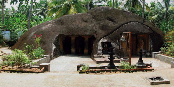
Boothalingaswamy Temple complex (பூதலிங்கஸ்வாமி கோவில் வளாகம்) includes the rock cut cave  The cave temple is excavated on the eastern slope of the side of the hillock situated in the middle of the village. This temple comprise an outer prakara, inner prakara and the main cave with a frontward pillared mandapam  constituting a large complex. The rock cut cave forms nucleus structure around which temple structures added in the subsequent period of time. Altogether forming the large temple complex.

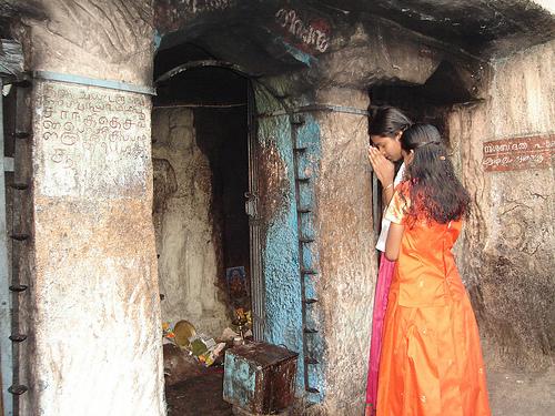
A large perimeter wall in the periphery encloses the outer prakara. The temple is accessible from four entrances. The western entrance is through three tier gopuram or gateway. The gopuram has granite base and three tiered brick super-structure decorated with stucco images. The pillars, supporting base tier of the gopuram, bear images of the donors (of the temple) appear in folded hand gesture (mudra) On the west face of the tower there are two guards in stucco images appear holding small and large clubs in each of their hands. On top of the boulder towards east of this tower, there are two stucco images: one is a milking cow and the other one is Lord Shiva with trident.    . 


Bhoothalingaswamy-Temple-in-Dovalai-in-Kanyakumari-7.jpg (1065×1600)

Bhoothalingaswamy-Temple-in-Dovalai-in-Kanyakumari-8.jpg (1065×1600)

6949d038e3612f03e07966d9a829ccda.jpg (700×394)

There are two entrances on the south wall. The westward entrance arch on the south wall is decorated with stucco image of Lord Shiva with consort Uma in Ananda-thandava posture. Also there are two musicians on either side of dancing Shiva. The eastward entrance on the south wall leads to the river Pazhaiyaru. The simple entrance on the eastern wall is located before the sanctum of the prime deity.  The entrance on the northern wall leads to the temple tank with a mandapam in middle (நீராழி மண்டபம்)

Bhoothalingaswamy-Temple-in-Dovalai-in-Kanyakumari-2.jpg (1600×1065)
Southern inner entrance leads to Pazhaiyaru river
On the western side to the left of the entrance of the outer prakara adjoining the rock slope is the shrine for Sastha. There is  a Pillaiyar shrine under the tree The inner perimeter wall encloses the sanctums of the prime deity, goddess Sivakami, shrines for minor deities, mandapams and inner prakara. The parts of the inner southern and northern walls sit on the rock. There are three entrances leading to the inner prakara: One entrance on the southern wall, other two entrances on the eastern and northern walls. The eastern entrance leads to sanctum of the goddess Sivakami. Another entrance with single tier gopuram leads to the prime sanctum. The southern entrance leads to Pazhaiyaru river.  This entrance is supported by adishtana, pillars with square, kattu, square sections, vettu-potikas and prastara components. The ornamental arch houses the  celestial wedding event: Lord Vishnu handing-over goddess Meenakshi to Lord Sundareswara. 

The inner prakara extends on all three sides except the rocky western side. The inner prakara includes sanctums of god and goddess as well as shrines for minor deities i.e., Kanni Vinayagar, Sastha and Somaskanthar.  Somaskantha shrine has sanctum and mukha-mandapam and vimana with nagara griva and shikara. Sastha shrine has eka-tala nagara vimana and sanctum guarded by dwarapalakas (boothas). Kanni Vinayagar shrine has eka-tala vesara vimana and sanctum and mukha-mandapam. Chandigeswara shrine and Dakshinamurti shrine are located on the north and south side prakara of the prime deity.  There is a shrine for Lord Muruga and his two consorts Valli and Devayani.

Mandapam

Two mandapams are located before the sanctums of god and goddess and they are known as wedding mandapam (கல்யாண மண்டபம்) and Chettiar mandapam (செட்டியார் மண்டபம்). The wedding hall is supported by ornate pillars with bas relief sculptures. Some are simple pillars sectioned by square kattu and square and some other pillars are composite pillars. The cupid or Kamadeva Manmatha and his love Rathi images appear on a pillar. The Chettiar Hall is also supported by ornate pillars with bas relief sculptures. Some are huge Yali pillars.

Sivagami Amman Shrine

The east facing Sivagami Amman shrine has a two tier vimana, mukha-mandapam and large mandapam. The vimana, built on a granite base with a brick superstructure, has a kapotabanda adhishtana and the vedika component is shown in between the adhishtana and pada (wall). The octagonal (Vishnu-kanta) pilasters with nagabandha pada support the roof. The potikas above the pillars are madalai with nanudal  tipped with sharp bud bearing the prastara components that adjoin the roof. The three sides of the external walls are sectioned and shown as simple koshta-panjara.  The Adi-tala hara walls have been raised considerably high and the second tala also has hara walls. The stucco images adorn in sala and griva koshtas.

Mandapam

The mukha-mandapam and large mandapams were added before the cave sanctum of the prime deity during later age. The mukha-mandapam has supportive floor, wall supported by square pilasters, taranga potikas and prastara components. Kapota has ornate kudus. The large mandapam can be accessed through entrances at east and south walls. Mandapam is supported by square kattu square kattu square pillars with vettu potikas. The bronze idols are protected in this mandapam. The Vinayaka idol in lalitasana posture is found in the inner mandapam.

Cave Sanctum

The Cave sanctum is .1.71 m in the north-south direction; 1.38 m in the east-west (south wall) direction; 1.46 m in the east-west (north wall) direction; with the height of 1.73 m..The floor, roof and the walls of the cave sanctum are well formed. The sanctum entrance is 0.67 cm in width and 1.60 m in height.

The sanctum houses Boothalingaswamy (பூதலிங்கசுவாமி) in the form of Shivalingam.  Shivalingam is sculpted out of the mother rock and the rectangular 'avudai' measures 0.80 cm in length in the north-south; 0.75 cm in width in the east-west directions and 0.52 cm in height. The external faces of avudai  is embellished with padabandha adishtana with components such as jagadi (ஜகதி), vritta kumudam (குமுதம்), khanta flanked kampa and pattaka mouldings. The rudra (cylindrical) bana sits on the square avudai.  A small pit is shown towards north to receive the anointed water. A water chute is seen running up to the north wall of the sanctum and continued in the east wall of the sanctum.

History

The cave temple has been named after the presence of Bhoothalingaswamy Temple (Bhoothapandi), which is famous for its sculptures and architecture. The cave temple was excavated by King Pasum Pon Pandyan, the son of Boothapandiyan, Flag post of this temple is very tall and the temple car here is very old  and higher in weight.  A shrine dedicated for Tamil Poet Avvaiyar is located at 5 km away from Bhoothalingaswamy temple.
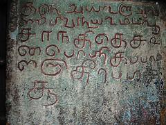
Inscriptions


Kanyakumari District Inscriptions volume 5.  (கன்னியாகுமாரி மாவட்டக் கல்வெட்டுத் தொகுதி 5) Chennai, Department of Archaeology Government of Tamil Nadu, 1969 pp. 69 - 81 has published eleven inscriptions copied from this temple as well as two inscriptions from North street of this village.  The first inscription located nearer to Jeeva library cites two streets in the name of Udhaya Marthandan (உதய மார்த்தாண்டன்) and Boothala Raman (பூதல இராமன்) an asylum to someone under threat also known as Abhaya Dhanam (Jainism) or Anjinan Pukalidam (Tamil அஞ்சினான் புகலிடம்). Another inscription dated 19th day Tamil month Thai 1691 A.D.was inscribed on behalf of Adi Chandeswara endowment. The inscription is about Vadakku Saliyar, weaving community people (Padmasali), who lived in this village during 17th century A.D. They migrated to Vadaseri (near Nagerkoil) after lot of suffering and they were colonized back in Boothapandi village.

Inscription dated Tamil month Masi, year 1789 cites the installation of flag-post in this temple. Another inscription on the pillar of Nandi Mandapam records one Thanumarthandan.(Tamil தாணுமார்த்தாண்டன்). Remaining nine inscriptions are inscribed on the walls of goddess Sivakami (Amman) shrine. Inscription dated 1578 A.D. records the gift of 25  numbers of five wick oil  lamps standing on their stems and pedestals, fabricated in brass (குத்துவிளக்கு) by one Ayyappan Pariyerum Perumal of Boothapandi village. The lamps would be burnt before the prime deity. It also includes land endowments for daily oil consumption. The gift was accepted by Sri Karyam (temple) staff. Signed by Puttur Eswaran, Sri Karyam (temple) accountant,, Kannan Govindan, Treasury accountant and Bootha Nambiyar, Endowment accountant.

Inscription dated 1581 A.D. records the assurance made by Sri Karyam staff to offer one measure of ghee and ten banana and arrange for the celestial dance of prime deity during pooja rituals every month on the Apara (Pitru) Paksham, Ashtami (eighth) tithi day. For this purpose the staff accepted one hundred 'panam' as deposit from one Kali-paappan of Perumanguli desam in Mudala Nadu district, forming part of Malai Mandalam province (Tamil: மலை மண்டலத்து முடாலா நாட்டுப் பெறுமாங்குழி தேசத்துக் காளிபாப்பன்). Another inscription dated 1581 A.D. records the land endowment for pooja rituals and offerings to the prime deity on the Vasantham day, Tamil month Chithirai by one Eswaran Kesavan of Makizhanjeru house in Kadaikkasu Desam (Tamil: கடைக்காசு தேச மகிழஞ்சேறு இல்லத்து ஈஸ்வரன் கேசவன் ). Inscription also cites places like Azhagiya Pandiyapuram, Kadukkarai, Pallacha Peru and Veeraneri Kulam.

Inscription dated 1583 A.D. records the deposit of two hundred 'panam' made for pooja rituals of Lord Dakshinamurti by Pasumpirathu Gangaiyadi Bhattar of Azhagan Azhaga Chaturvedimangalam of Padmanabhanallur (Tamil பத்மநாபநல்லூர் அழகன் அழகச் சதுர்வேதிமங்கலத்துப் பசும்பிறத்து கங்கையாடி பட்டர் ). Yet another inscription dated 1607 A.D. records the deposit of three hundred 'panam' for purposes of early morning rituals (திருப்பள்ளியெழுசசி), ablution (அபிஷேகம்) and offerings (படையல்) to the prime deity in the name of one Sooranai Vendra Adittan of  Padmanabhanallur aka. Murungur of Nanjil Nadu (Tamil நாஞ்சில் நாட்டு முருங்கூரான பத்மனாபநல்லூரில் சூரனை வென்ற ஆதித்தன்).

Incomplete inscription dated 1614 A.D. records the deposit of seven hundred 'panam' for purposes of pooja rituals and offerings for procession deity Lord Chandrasekarar during new-moon day procession by one Velayudha Perumal of Mulainallur in Nanjil Nadu (Tamil: நாஞ்சில் நாட்டு முளைநல்லூர் வேலாயுதப்பெருமாள்). Mentions the temple staff and their specific duties during procession as well as minor deities. Another inscription dated 1618 A.D. records the deposit / gift of nine hundred 'panam' for purposes of procession of prime deity and goddess on 'Bharani' star day in Tamil month 'Chithirai' by Settu Silaiyan Ariyakutti, a resident of Tiruvidangur Ravi-varmar (aka. Kulasekara Perumal) street. Specific expenses include feeding the brahmins, Maheswara pooja rituals, rice flakes, Nambimar Adangal, Sala Sambavinai, Namimar Tantra Salavu, evening ablution, camphor etc.

Inscription dated 1658 A.D. records the royal order issued by Elder Thambiran Eraivai Ravivarma,during his stay in the palace of Boothapandi after pooja rituals of the temple. The royal order is in consideration of peasants plea on vacating stay of land charges vs the defense side representation made by the revenue staff.  Inscription without date lists out the offerings made by the temple authorities to the Pooja rituals of Lord Chidambareswarar during the Tamil month Markazhi.
    
Temple Timings : Morning 4:00 A.M. – 11:00 A.M. Evening 4:00 P.M. to 7:30 P.M.

Poojas & Festivals: Pradosham (13th tithi) Day, Special pooja on New moon Full moon days. Annual festival on Thai (Tamil) month and Chithirai (Tamil) month. 

How to get there?

The town of Boothapandi is connected to Nagercoil by road.
Nearest railway station: The closest railway station is the Nagercoil Junction Railway Station.
Nearest airport is the Tiruvanandapuram International airport

Reference
  1. Bhoothalingaswamy Temple Bhoothappandi. Tourism Everyone. 
  2. Bhoothalingaswamy Temple Bhoothappandi. Find My Temple.
  3. Bhoothalingaswamy Temple, Bhoothappandi (Wikipedia)
  4. பூதப்பாண்டிக் குடைவரை பல்லவர் - பாண்டியர் - அதியர் குடைவரைகள். மு.நளினி மற்றும் இரா.கலைக்கோவன். சேகர் பதிப்பகம், சென்னை, 2012. பக். 221 - 233. 

Saturday, November 5, 2016

Sivagiri Sri Mahadevar Cave-temple Alvarkoyil: Hindu Rock cut Cave near Nagerkoil, Tamil Nadu, India

Sivagiri (சிவகிரி) Sri Mahadevar (ஸ்ரீ மகாதேவர்) Rock cut cave temple is located in Alwarkovil (ஆழ்வார்கோவில்) village, Kalkulam (கல்குளம்) taluk, Kanyakumari district, Tamil Nadu, India and the village is forming part of  Eraniel Town Panchayat.  The geographical coordinates of Eraniel (Eranyasinga nalloor) are 8.2°N latitude 77.3°E longitude. It has an average elevation of 10 meters (32 feet). There is a small palace located near Eraniel. It is nearer to Thuckalay. Alwarkovil is 30 km away from Nagerkoil.

Architecture

The east facing Sivagiri (சிவகிரி) Sri Mahadevar (ஸ்ரீ மகாதேவர்) rock cut cave temple is excavated on the eastern slope of Sivagiri hillock and therefore the cave lies in an east-west orientation. The prime deity Shivagirinathar appear in the form of Shivalingam and the Shivalingam image is sculpted out from the mother rock of the cave. The rock cut cave forms nucleus structure around which temple structures added in the subsequent period of time. The cave temple complex comprise a mukha-mandapam, cloister-mandapam (சுற்றுமாளிகை ) and another large mandapam (பெருமண்டபம்)..

Cloister Mandapam

The cloister mandapam is built around the three sides of single celled cave. The adhistana and the pillars of this mandapam are highly ornamented. On the east wing of the cloister mandapam is supported by composite pillars with amazing yali (யாளி) motif. Yali is a mythical creature seen in many  temples, often sculpted onto the pillars.  The pillars supporting the north and south wings of the cloister mandapam are sectioned as square, octagonal kattu, square, octagonal kattu and square. The facade of the cloister mandapam has a corridor (open court) and the access can be made through two entrances located on the east and north wings. The south entrance of the cloister mandapam leads to temple kitchen (மடப்பள்ளி) and large mandapam.

Nandi Mandapam

In the center of the mandapa there is a Nandi mandapam. The seated Nandi on a platform is facing Shivagirinathar, the presiding deity. Nandi mandapam is built on a plinth (adhishtana) with jagadi, khantam and peruvajana mouldings. The four pillars of the Nandi mandapam are sectioned as square, octagonal kattu, square, octagonal kattu and square. Above the pillars there are vettu potikas (corbel brackets) holding the prastara components such as uttira (beam), vajanam, valabhi and kapotha.

Mukha-mandapam

Mukha-mandapam is built to the west of Nandi-mandapam i.e., adjoining to the rock wall of the cave. It has a padabandha adhisthana with jagadi, octogonal kumudam, kantha with pada and flanked by kampa and pattika mouldings. Above the adhisthana is the vedika with vedikanda.  Mukkha-mandapam is supported by four square pilasters with capitals. The vettu potikas (corbel brackets) holding the prastara components such as uttira (beam), vajanam, valabhi and kapotha with kudus. The south and north walls are sectioned with square pilasters and shown as simple koshta-panjara. The entrance on the east wall is 0.61 cm in width and 1.36 m in height.

The sanctum can be approached either from flight of three steps with balustrade on the south or from similar flight of three steps with balustrade on the north. The two sets of flight of steps leads to the raised plinth with upana, thamarai, khanta and kapota mouldings.

Sanctum

The entrance from mukha-mandapam is supported by square pilasters on either side. The sanctum excavated from the rock. The sanctum measures 1.72 m in width in the north-south direction and 1.70 m in length in the east-west direction and 1.70 m in height. The sanctum entrance is 0.85 cm in width and 1.46 m in height. The sanctum houses Shivagirinathar (சிவகிரிநாதர்) in the form of Shivalingam.  Shivalingam sculpted out of the mother rock and the square 'avudai' measures 0.24 cm in height and 0.65 cm in length on all four sides. The cylindrical bana sits on the square avudai. The walls and roof of the sanctum are simple and plain.

How to get there?

One can easily get regular buses to Eraniel from other major cities of the country. All buses from Thingalnagar bus stand will pass through Eraniel. Many buses run from Nagercoil via Eraniel. For every 5 minutes you have buses to Nagercoil and for every 15 minutes you have buses to Thuckalay
Nearest railway station is Eraniel railway station. Nagerkoil railway station is the main junction
Nearest airport is Thiruvananthapuram International Airport. - 72 km away

Reference
  1. சிவகிரிக் குடைவரை தென்மாவட்டக் குடைவரைகள். மு.நளினி மற்றும் இரா.கலைக்கோவன். (தென்தமிழ்நாட்டுக் குடைவரைகள்: தொகுதி 3). டாக்டர் மா.இராசமாணிக்கனார் வரலாற்றாய்வு மையம், திருச்சிராப்பள்ளி. 2009. பக். 148 - 150. 
  2. சிவகிரி (sivakiri) - ஸ்ரீ மகாதேவர் (ஆழ்வார்கோவில்) திருக்கோவில்; தக்கலை - ஆழ்வார்கோவில்.

Friday, October 28, 2016

Kurathiarai Cave Temple: Hindu Rock cut Cave near Nagerkoil, Tamil Nadu, India


Picture Courtesy: RK Lakshmi (Facebook)
Kurathiyarai (குறத்தியறை) Rock cut cave temple is located in Thovalai (தோவாளை) taluk of Kanyakumari district, Tamil Nadu, India PIN 629851 and the village is forming part of  Azhagiapandiapuram (அழகியபாண்டியபுரம்), town panchayat. Kurathiyarai village is situated in the Nagerkoil - Kadukkarai road. Take diversion before Azhagiapadiapuram and and find out muddy road and travel one km to reach this village. The geographical coordinates of Azhagiapandiapuram are 8°18′35″N latitude 77°26′45″E longitude. As of 2001 India census, Azhagiapandiapuram had a population of 12,060 5966 male and 6074 female). Azhagiapandiapuram is 17 km away from Nagerkoil, 

Kanyakumari district well known for places of legendary, historical and artistic importance. You would be enthralled to see the lush green paddy fields, swaying palms, meandering dusty gravel  roads, bullock carts crawling with loads of straw bale, and criss-crossing water streams. Agriculture is the main occupation in this region. Thovalai and the surrounding area is involved in the fresh flower industry for sale to domestic and foreign markets. The Nagerkoil is the base destination to visit Kanyakumari, Udayagiri fort, Padmanabhpuram Palace, Muttam Beach, Tengapattinam Beach, and Krishnancoil temple.

Architecture

The south facing rock cut cave is excavated on the slope of the hillock at the outskirts of the village. The cave cell is excavated 0.95 cm in width and 1.77 m in height and east-west in orientation. The entrance is 80 cm in width and 1.30 m in height. Local people made provision for wooden door and walls coated with cement. 

The horse shoe shaped cave excavation remains incomplete and the floor, roof and walls of the cave appear coarse. The sanctum is 1.52 m in east-west in length and 1.13 m north- south in width and 2.04 m in height. The niche carved on the rear wall measures 40 cm in height. The niche, flanked by two square pilasters,  houses Lord Vishnu. The pilasters support the angular potika and uttira.  The prastara including vajanam, valabi and kapota are absent.  

Picture Courtesy: RK Lakshmi (Facebook)

Lord Vishnu image appears in samapatha sthanaka posture on the rear wall and image is dull and smudged with oil. The Lord wears kreeta makuta, kundala ear-ring, yagnopavita (sacred cord) runs across his chest, and drapes dhoti as a five fold tuck in wrap (panchkacha) and the waist cloth (idaikattu) is tucked with knot. He holds the chanka (conch) in his back right hand and his back left hand holds Chakra (disc wheel). His right forearm rests on the hip and the left forehand kept half folded. Scholars assign the date of Vishnu as eighth century A.D. 

Picture Courtesy: RK Lakshmi (Facebook)


Two niches carved are carved outside on the rock slope one on each side of the cave entrance. The niche on the west of the entrance is 89 cm in height and 63 cm in width and houses Vinayagar idol The Vinayagar is seated in posture described as ‘Lalitasana’ (posture of royal ease) with his right leg drawn up and folded and the left leg resting on the ground. The Lord in ‘Lalitasana’ represents a calm and relaxed deity and the idol appear with trunk to the right side is known as valampuri Vinayagar (வலம்புரி விநாயகர்). The Lord wears karanda-makutam (கரண்டமகுடம்), sarapali (சரப்பளி) in the neck, armlets (தோள்வளை), bracelets (கைவளை) and short robe around the waist. The right tusk is present while left tusk is absent. The back left hand is damaged and the back right hand shows kapitha mudra. The right fore-hand holds an object which is not unidentifiable and left forehand rests on the lap.

The image on eastern niche is left incomplete and sculpting do not show any shape. However the local people worship this image as Avvaiyar.  Although the presiding deity in this cave is Vishnu, the temple is locally known as Avvaiyaaramman koil. The image on the left side of Lord Vishnu is believed to be that of Avvai.

History

The worship of Avvaaiyar in Thovalai taluk in Kanyakumari district is locally as Avvai Nonbu or Avvai Vratham. The Tuesdays of Tamil month Adi is most auspicious for Avvaiyar worship. Womenfolk offer 'Kozhukkattai' (steam boiled rice ball with sweet stuffing) to Avvaiyaaramman.

From inscriptions from Chitharal mountain, there was a Jain cave temple at the top of Chitharal mountain and was known as Thiru Charanathu Malai.  The monks belonging to the Digambara sect established Thiru Charanathu Palli – the abode of Jain monks during 9th century A.D. Thiru Charanathu Palli was a dynamic center of Jain learning - a monastery and a school. The male teacher was called ‘kuravar’ and the female teacher ‘kurathi.’ The word Kurathi (குறத்தி) also denotes a Jain nun. Influence of Jainism in Kurathiyarai is evident from the first syllable 'Kurathi. The inscription also cites the Ay king Vikramaditya Varaguna (885-925 AD). The scholars assign the date of the cave to 8th century A.D.

How to get there?

Bus Route: Thovalai is well connected by bus from Nagerkoil and Kanyakumari.
Nearest Railway station: Nagercoil Junction is a major railway junction connecting the southern tip of India with all parts of India.
Nearest Airport Thiruvananthapuram

Reference

  1. Kurathiarai Rock-cut Cave -Nagercoil -Kanyakumari DistrictRK Lakshmi. Facebook.
  2. Tales of Avvaiyaar March 6, 2009 (http://hmindia.blogspot.in/2009/03/ack-086-tales-of-avvaiyaar.html)
  3. குறத்தியறை.  மு. நளினி. வரலாறு.காம் இதழ்  47. மார்ச் 16 - ஏப்ரல் 17, 2008.

Sunday, October 2, 2016

Vizhinjam Cave: Hindu Rock cut Cave in Vizhinjam near Tiruvananthapuram, Kerala


Vizhinjam (വിഴിഞ്ഞം) rock cut cave is located  in Vizhinjam village, Athiyanoor (അതിയന്നൂർ) taluk in Thiruvananthapuram  (തിരുവനന്തപുരം) district, Kerala State, India PIN 695521. The cave is located 14 km towards South from District head quarters Thiruvananthapuram. Vizhinjam is located 2 km from Athiyanoor; 3 km from Kottukal (കൊടുക്കൽ ); and 3 km from Kovalam beach (കോവളം ബീച്). The Latitude and Longitude coordinates in degrees, minutes, seconds decimal and degrees decimal of Vizhinjam is 8°22′45″N (8.3932)  and 76°59′29″E (77.0046) respectively. The elevation / altitude of Vizhinjam is 71 meters above Sea level. As per 2011 Population Census 2011, the village has population 20714 (males 10277 and females 10437) and 5040 families in total The village is also the natural port located close to international shipping routes and it is an international deep-water multi-purpose shipping hub.  Neyyattinkara (നെയ്യാറ്റിന്കര),  Kollankodu (കൊല്ലങ്കോട് ), Nedumangad (നെടുമങ്ങാട്) are the nearby Cities to Vizhinjam.

Architecture

The Vizhinjam rock cut cave temple premises, under the maintenance of ASI, is located near Vizhinjam bus-stand. Like the Kilmavilangai and Mahendravadi rock cut caves in Tamil Nadu, Vizhinjam cave is excavated on a small boulder measuring about 3 m (9 feet 10 inches) in height and 3.50 m (11 feet 5 inches) in width. On the eastern face of this outcrop, is carved in a single cell sanctum measuring about 1 m (3 feet 2 inches) east-west in length,  0.70 m (2 feet 3 inches) north-south in width and 1.50 m (4 feet 11 inches) in height. The roof slopes towards east. The rear, south and north walls left unfinished. The single cell sanctum houses a loose sculpture of (east facing) Vinadhara Dakshinamurthy (an aspect of Lord Shiva as a guru (teacher) of all types of knowledge and the great teacher of music) of later period.

There are two plain square pilasters (door frames) cut on either side of the sanctum entrance. The pilasters directly supports the prastara component uttira. Towards the south and north of the pilasters there are two rock cut niches housing bas relief images. The right side niche (formed without pilasters) houses the sthanaka Shiva accompanied by two dwarf images on either side. Shiva appear standing on his right foot planted on the even floor (Sthitha paadam) and the bent (folded) left foot firmly stamping upon the head of the demon "Muyalagan". The demon Muyalagan appear seated on two squatted legs. His left hand holds the bow. A roughly sculpted dwarf gana appears on the left side of Muyalagan. 

Lord Shiva drapes a piece of loin cloth (A loincloth is a long piece of cloth, passed between the thighs and wound around the waist) and knotted waist cloth. Shiva appears with two arms and the left forearm holds the tall bow; the upper left hand holds ‘mazhu’ (the axe); the right fore arm holds the arrow while the upper right  hand in ardhapathaka (mudra) gesture. The jatamakuta is the hair dress with head band (நெற்றிப்பட்டம்).  The lord wears sarapali around his neck.and the Yagnopavita is worn in niveda fashion. He also wears a palm-leaf coil as ear-ring at his left ear lobe and the right ear lobe locked with kundala.

The left side niche (formed without pilasters) houses the two bas relief images. The right side male image appears in dancing posture and his left leg is held in parsvatha posture while his right leg held in swastika posture. The face is tilted towards his right side. The lord wears conical jatamakuta. The left ear lobe is adorned with palm-leaf coil as ear-ring. The ankle is adorned with beaded chain.

The left side female image rests her left hand on her hip and the right hand rests on her chin. The waist cloth tied with knots. The left leg is damaged and the right leg plated on the floor. The identity of these two images could not be established clearly.  

History

In the words of Ptolemy the territory of Ay (ஆய்) flourished in the south of the Chera kingdom and extended from Nelcynda to Kumari and the Pandya kingdom lay only 'past Komaria.' According to Robert Sewell Ayes were the rulers of the hill country. Chera dynasty established themselves in major portions of Chera land (present northern Kerala) as the vital force only after Ay dynasty (ஆய் வம்சம்) established themselves around the Potiya hill (பொதியமலை), the southern most section of the Western Ghats. (presently the southern Kerala). So the Ay dynasty  ruled the land between Nagercoil and Thiruvalla and Vizhinjam, the port town, was once the capital of many dynasties including Ay dynasty.  Important Ay rulers are Ay Andiran (ஆய் அண்டிரன்), Titiyan I (முதலாம் திதியன்), Atiyan (அதியன்), Titiyan II (இரண்டாம்  திதியன்) and Nanchil Porunan (நாஞ்சில் பொருநன்). Purananuru (புறநானூறு) extols Ay Andiran as the philanthropic ruler who independent ruled the potiyi hills. He is praised for his patronage as Vel Ay (வேல் ஆய்) and Ma-Vel Ay (மாவேள் ஆய்) by the Sangam poets in Purananuru. Ay Andiran drove Pandyas from his territory and came to prominence around 96 - 140 A.D. Titiyan I was praised as 'Potiyir Selvan' (பொதியிற் செல்வன்). During the time of Atiyan Ay kingdom got disintegrated. It seems that Alakiyapandiyan waged war over Ay kingdom and defeated Atiyan and Ay kingdom was reduced as a tributary of Pandya kingdom. Later the battle between Talayalankanattu Ceru Venra Nedunceliyan Pandya king (தலையாலங்கானத்து செரு வென்ற பாண்டியன் நெடுஞ்செழியன்) and Titiyan II clashed at the historical battle  at Talayalankanam (தலையாலங்கானம்) and sealed the fate of the Ay kingdom. 

Ay dynasty was later known as Venad (வேள்நாடு / வேணாடு) dynasty and the kingdom located to the south of Chera kingdom. It was later on known as the Tiruvidankur dynasty (திருவிதாங்கூர் வம்சம்).  Karunandadakkan (857-885 AD) (கருணானந்தக்கண்) an illustrious Ay king ruled with his capital at Vizhinjam. His earliest inscription in South India found dated in the Kali era (கலி வருடம்). It throws light on the working of ancient highways (salais) or Vedic colleges. According to the Huzur Office (copper) plates Ay (Vrishni Kula) King Karunandadakkan built the Parthivapuram Parthasarathy Temple (பார்த்திவபுரம் பார்த்தசாரதி கோவில் ) and consecrated in 857 A.D. Vikramaditya Varaguna (885-925) succeeded Karunandadakkan. The Paliyam Copper plate of Vikramaditya Varaguna (885-925) (விக்கிரமாதித்ய வரகுணா) records the grant of an extensive landed property to the Buddhist of Srimulavasa Vihara (ஸ்ரீமூலவாச விஹாரை) by the ruler. The Copper Plates indicates the origin of Ay from Ayars. (Ayars also known as Yadavas). .Ayakkudi (ஆயக்குடி) near Aralvaymoli (ஆரல்வாய்மொழி) gives some idea about Aye kingdom of Sangam age.

The Chola Empire Parantaka I (907 - 955) Chola (முதலாம் பராந்தக சோழன்) defeated Maravarman Rajasimha (மாறவர்மன் இராஜசிம்ஹன்), the Pandya king and annexed the South Kerala and Nanchil Nadu (Tiruvidankur) during 10th century A.D. The inscriptions of Parantaka I are found in Suchindram.

This land was also the scene of many battles. In 788 A.D, Jatilavarman Parantaka (Maranjadayan) the Pandya king waged a war over Ay kingdom and encircled Vizhinjam port. The Pandya conquered the Ays and made it a tributary state. Also military campaigns between the Kulasekara rulers (rulers of Venadu) and the later Cholas took place in this region. Vizhinjam also seems to have served as the former Dutch and British factory.

Temple timings: 0900 - 1800 hrs. It remains closed on Mondays.
Best Season: October to March

The Vizhinjam International Transhipment Deep water Multipurpose Seaport is an ambitious project taken up by Government of Kerala. It is designed primarily to cater container transhipment besides multi-purpose and break bulk cargo.

How to get there?

Nearest Bus-station: K-S-R-T-C-Vizhinjam-Bus-Station. A good network of roads connect Vizhinjam with several tourist destinations. within Kerala and India. State buses and inter-state buses can be availed to reach Vizhinjam.
Nearest Railwaystation: Nemem Railway Station , Balabnramapuram Railway Station are the very nearby railway stations to Vizhinjam. How ever Trivandrum Central Railway Station is major railway station 13 KM near to Vizhinjam
Nearest Airport: Trivandrum International Airport- 14 KM

Reference 
  1. Archaeological Survey of India. Thrissur Circle. (http://www.asithrissurcircle.in/Monuments.html)
  2. Historical background of Travancore - Shodhganga (PDF)
  3. History of South India – Part 5: Kingdoms of the Sangam Period - The Chera Dynasty. Bharat: An Untold Story. 
  4. Rock cut cave temple, Vizhinjam. Travelogues of a Compulsive Roamer. Saturday, 9, 2014
  5. Vishnu temple of Ay Dynasty. Varnam. February 2, 2005
  6. Vizhinjam Cave Temple. Wikipedia
  7. Vizhinjam in historical perspective. The Hindu July 27. 2015
  8. Vizhinjam Rock Cut Cave Temple. Indian Holiday.com
  9. Vizhinjam Rock Cut Cave, Thiruvananthapuram. Keralatourism.org
  10. விழிஞம் குடைவரைக்கோயில் இரா. கலைக்கோவன் Varalaru.com

YouTube
Vizhinjam's cave temple wows tourists by asianetcablevision


Thursday, September 29, 2016

Madavoorpara Cave: Hindu Rock cut Temple near Thiruvananthapuram, Kerala


Madavoor_Para_Cave_Temple.jpg (3600×2160)

DSC_7231.JPG (1278×855)

62_big.jpg (500×375)

51_big.jpg (240×180)

madavoorpara.jpg (960×1280)

Madavoorpara rock-cut cave temple is situated in Madavoopara village, Kazhakuttam taluk, Thiruvananthapuram district, Kerala, India PIN 695587. It is forming part of Ayiroorppara Panchayat and located between Pothencode and Chempazhanthy.. The cave is located 15 km towards North from District head quarters Thiruvananthapuram.  Madavoopara is geographically located at latitude  8 ° 35′ North and longitude 76 ° 59′ E' and the altitude / elevation is 64 m (210 ft). The rock cut cave temple was owned by the Chenkottukonam Ashram and from 1960 the premises is protected by the State Archaeological Department. It is one of the two rock cut caves in Thiruvananthapuram district.

Architecture

The rock cut cave excavated on the solid rock face on top of the hillock. To reach the cave, you have to climb more than 200 steps. The flight of thirty three steps, sculpted on the rock, leads one to the square-shaped cave temple. The rock cut cave is dedicated to Lord Shiva. The images of Lord Shiva and Lord Ganapathy sculpted on the right side of the wall. On the left side there is an image of the local chieftain.  

History

Buddhism and Jainism spread in Kerala around 3rd century A.D. Jainism continued to have strong hold for about 700 years in south Kerala region.  The earliest Buddhist rock-cut cave abodes were built for Buddhist missionaries (monks) by the kings and traders on the busy international trading routes. Vikramaditya Varaguna (885–925), the Ay king popularly known as Ashokan in Kerala, ruled parts of south Kerala. The Paliyam Copper Plate "Sreemoolavasam cheppedukal"  was issued by this king in the fifteenth year of his rule (925 AD). The plate describe Varagunan as "vrishnikulajathan," a Buddha devotee.   The copper plate bears the evidence of the patronage extended by the ruler i.e., the donation of land to Thirumoolavadam (Sreemoolavasam), to Buddhist missionary. Buddhism was held in the highest respect and veneration by this ruler. The copper plate includes the invocation phrases like 'Buddha' and 'Dharma.' Till 1000 A.D. Buddhists continued to enjoy royal patronage . 

Hindu Revivalism in 800-1000 A.D. gradually get rid of Buddhism from Kerala. It is believed that many Buddhists and Jain shrines were converted into Hindu temples. Madavoorpara is an ancient one dating back to 850 A.D. According to one theory the rock-cut cave could have been built for Buddhist monks and another theory gives this credit to Jain monks. This temple, which resembles the ancient cave temples of the Jains,   

Inscription

There is an ancient vattezhuthu inscription near the shrine.

Tourist Attraction

The lone Madavoorpara cave is located amidst rubber plantations and hence less explored destination till recent past. The local media, state tourism and the State Archaeological Department have initiated steps to attract tourists and locals. A small park and a 101 mt long bamboo bridge have been formed by he State Archaeological Department. The panoramic view from atop the hillock is an amazing experience.

'Ganga Theertham' the holy pond receives water from the perennial stream. Shivratri is the main annual festival celebrated in this cave temple and this event attracts thousands of devotees from far and near.

How to get there?

By road: You may take the Chempazhanthi-Potherncode route to Madavoorpara from Sreekaryam. You will reach Kattayikonam after 7 km. Take note of the Madavoorpara temple sign board on your right. You can also take the alternate route i.e., Powdikonam-Pothencode route from Sreekaryam. Drive  8 km to reach Santhipuram and divert left turn and proceed 2 km further to reach the site. There is an advantage of preferring this route i.e., you  don't have to climb up the rock.

Nearest Railway station: Kazhakuttam Railway station , Kaniyapuram Railway station are the very nearby railway stations to Madavoorpara. However Thiruvananthapuram Central Railway station is city railway station.

Reference
  1. Madavoorpara Cave Temple http://www.techmodi.com/demo/mygod/temples/MTcw/temples_detail
    Madavoorpara Siva Temple. C.P.R. Environmental Education Centre, Chennai
  2. Paliyam Copper Plate. Kerala culture.org
  3. Rock of Ages The Hindu March 27, 2015
  4. Sunday visit to Madavoorpara Rock cut temple in Trivandrum. Travelogues of a Compulsive Roamer (http://ranjithsudhakaran.blogspot.in/)
  5. Temples of Thiruvananthapuram. Kerala Windows.net  (http://www.keralawindow.net/templesoftrivandrum.htm)

YouTube
Madavoorpara Tourism. Madavoorpara Rock Cut Temple. Kattaikonam, Chenkottukonam, Trivandrum by Video Strawberry

Wednesday, September 21, 2016

Thrikkakkudy Cave: Hindu Rock-cut temple, Kaviyoor near Pathanamthitta, Kerala

hqdefault.jpg (480×360)


place3.jpg (432×432)

kaviyoor-rock.jpg.image.784.410.jpg (784×410)

thekkekudi-cave-temple.jpg (502×312)

Thrikkakudi rock cut cave temple is located about one km. north-east of Kaviyoor village, Thiruvalla taluk, Pathanamthitta district, Kerala, India PIN 689582.  The rock cut cave is located at a distance of 29 km from Pathanamthitta and 6 km from Thiruvalla, The meaning of the village name is like this: Thiru - kal - kudy’ that means - ‘sacred dwelling place in rock.’ The cave temple was renovated by Travancore Devaswom Board (TDB) and the board maintains with one daily morning pooja rituals. 

Kaviyur, a village panchayat, located on the western bank of the river Manimala, was a part of Nanruzhai Nadu which had its capital in what is now Thrikkodithanam, 9 km west of Kaviyoor. The Mahadeva temple of Kaviyoor,  built in 10th century A.D, is considered as one of the ancient Shiva (Mahadeva) temples in Kerala. Inscription dated 950 A.D. speak about gifts offered to this temple. The village  is one of the ancient 64 brahmin settlements of Kerala. The geographical coordinates Kaviyoor is Latitude 9°23′0″North (9.3920848)  and Longitude 76°36′0″East (76.6192022) and the elevation / altitude is from 8m to 61m.

The south facing Thrikkakudi rock cut cave consists of a facade, a rectangular mukha-mandapam and a sanctum. It is very skillfully cut into dome shaped roof. The plinth is plain and the cave floor little higher in level from the ground floor. A flight of four steps leads to the mukha-mandapam. The facade consists of two massive pillars in the middle and pilaster on both ends with the features of square, octagonal kattu and square. The walls are simple and plain with six foot high floor. The rough rock brow is bereft of any curved cornice moulding called 'kapota' (overhanging cornice) or drip line for rainwater.

The temple dedicated to Lord Shiva. The ten foot high and seven-foot square sanctum houses 3 feet tall Shiva lingam. The bas relief image at the door way represents Bhima, the Pandava prince of Mahabharatha.  Also there are bas relifs of Lord Ganapathi and the sage. The sanctum is guarded by imposing bas relief images of Dwarapalakas. The niches, on  the outer wall on either side of the entrance of the sanctum, houses these Dwarapalakas.. It is inferred by scholars that this cave temple was constructed in the Pallava architectural style and may be datable to 8th century. The natural pond amidst two rocks is another attraction. The rock-cut monument is protected by the Archaeological Department.

One version of the legend says that the rock cut monument was built by demons within one night. It is also believed that Lord Shiva and Hanuman of Kaviyur Mahadeva temple appeared here to interrupt the task of temple construction. The demons had to flee to save their lives. Another version says that the Pandavas of Mahabharatha dwelled in this cave during their exile in the forests.

In the words of Unnikrishnan, an archaeologist of repute, Thrikkakudi rock cut cave temple might have been a Buddhist vihara centuries ago. It is evident that Buddhism and Jainism flourished in this location before 10th century A.D.

Thiruvalla is well connected to other major cities of the country via regular buses. Kozhikode, Thiruvananthapuram, Kollam Kannur, Kochi , Coimbatore , Chennai, Madurai, Bangalore and Mangalore are connected from Thiruvalla through road.
Nearest Railway Station:  The town has its own Railway Station named as Thiruvalla Railway Station. It is  about 5 km from Kaviyoor.
Nearest Airport: Thiruvananthapuram International Airport, about 119 km from Pathanamthitta.

Reference

  1. Kaviyuur. Mathrubhumi (English) 31 May 2008.
  2. Kaviyoor Ente Gramam. Fa
  3. Rock-cut temple at Kaviyur, relics of a bygone age. Radhakrishnan Kuttoor. The Hindu. July 10, 2013.
  4. Remnants of a Bygone Era: Rock-Cut Temple at Kaviyur. Hithokthi.com 
  5. Thrikkakkudy temple, where time stands still. The Hindu. March 23, 2015.
YouTube videos


Friday, September 2, 2016

Kottukal Cave: Hindu Rock cut Cave Temple, Kottukal near Kollam


Kottukal-Rock-cut-Temple.jpg (700×350)

Kottukal-Rock-Cut-Cave-Temple.jpg (636×424)

Kottukal (കോട്ടക്കല്) rock cut cave, also known as Kaltrikkovil (കാലത്തിരിക്കോവിൽ) in Malayalam, is located in Ittiva (ഇട്ടിവ) village in Chadayamangalam (സദായമനഗലം) taluk in Kollam (കൊല്ലം) district, Kerala State, India PIN 691534.  Ittiva village, part of Ittiva village panchayat,  is in the border of the Kollam and Thiruvananthapuram (തിരുവനന്തപുരം) districts. This cave is located on the Thiruvananthapuram – Kottayam MC Road. The geographical coordinates of Ittiva are 8.8421200° North (Latitude) 76.864440° East (Longitude).  It has an average elevation of 52 m (170 ft). 

The name Kottukkal means carved rock in English (കൊട്ടിയ കല്ല് Kottiya Kallu in Malayalam). Kottukal rock cut cave  architecture typifies rock cut cave style of Kerala. The cave hewn out from a natural living hammock situated amidst paddy field. The hillock looks like an elephant in a sitting position. 

Architecture

The rock cut cave complex has two caves of uneven size. Both the caves are facing east. The larger cave has an almost square sanctum and pillared mukha-mandapam (rectangular hall). The rock cut façade has two massive supporting pillars. The smaller cave opens an oblong sanctum and there is no pillared mandapam. The cave-temple dedicated to Shiva. The sanctums have the monolithic Shiva lingams and the celestial bull (Nandi) idol. Another sanctum (niche) houses the image of sthanaka Hanuman (Anjaneya), the monkey god. In between the two caves there is a rectangular alcove like shrine housing the bas relief image of Lord Ganapathy (Lord Pillaiyar).  The cave temple complex also known for its well that never dries up.

History

Since the rock cut cave houses three deities Lord Shiva, Lord Ganapathy and Lord Hanuman, the name "Thrikovil" emerges. The rare association of Shiva Lingam, Nandhi and Anjaneya is seen only Kottukal and nowhere else in India such combination exists. According to some scholars the cave datable between 6th and 8th centuries A.D. Some other  historians assign the date back to 7th century A.D. Chadayamangalam named in remembrance of Nedila Paranthaka Nedumchadayan, who ruled Chadayamangalam between 6th and 7th century AD. 


The rock cut cave temple is administered by Travancore Devaswom Board and this body conducts daily pooja services. The state government of Kerala pronounced the Kottukal cave owned by Travancore Devaswom Board as the protected monument in 1966. 

How to get there?
  • Best Time to visit: December to May
  • Distance: Kottukal Rock cut Cave is located 10 km from Chadayamangalam and 8 km from Anchal. The place is 45 km away from Kollam and 65 km away from Tiruvananthapuram.
  • Nearest Bus stations; The village is connected through local bus service from Chadayamangalam and Anchal.
  • Nearest railway station: No railway station near to Ittiva in less than 10 km. Kollam (Quilon) Jn Rail Way Station is located 38 km away from Ittiva.  Punalur station 19 km; Thenmalai 23 km; Ottakkal 22 km.
  • Nearest airport: Trivandrum International Airport, about 60 km
Reference
  1. Kottukkal Rock Cave Temple GUHA Kshethram. Facebook. May 8, 2015 
  2. Kottukal Rock Cut Cave Temple. Mahrubhumi (English). May 31, 2008
  3. Kottukal Rock Cut Cave Temple. Tapioca.co.in
  4. The Cave Temple at Kottukal, Kollam. Kerala Tourism.org
  5. കോട്ടുക്കല്‍ ഗുഹാക്ഷേത്രം , അഞ്ചല്‍, കൊല്ലം (http://kudukka.com/coin123)

YouTube
Kottukkal cave temple by santhosh kottukkal


Tuesday, August 30, 2016

Akkanna Madanna Caves: Hindu Rock cut Cave Temple at Vijayawada


Akkanna-madanna_caves,_vijayawada_(19).JPG (4608×2592)


256px-Akkanna_Madanna_caves_Indrakeeladri_Vijayawada03.jpg (256×188)

Akkanna-madanna_caves,_vijayawada_(18).JPG (4608×2592)

Akkanna_Madanna_Rock_cut_Caves,_Vijayawada_city.jpg (1280×800)

Akkanna-madanna_caves,_vijayawada_(23).JPG (4608×2592)

Two east facing rock cut caves are located right at the footsteps of Indrakeeladri hills Vijayawada, Krishna District, Andhra Pradesh, India PIN 520010. The geographical coordinates of Indrakeeladri are 16°30'49" North (Latitude) ,80°36'23" East (Longitude) .  It has an average elevation of 39 ft from sea level. The famous Kanaka Durga Temple is located on top of Indrakeeladri hill, on the banks of holy river Krishna, Lower cave is located at the foot hills of the old foot-path route with narrow steps leading to the to Kanaka Durga shrine. Upper cave, datable to 2nd century B.C., is located  in the middle of the footpath,. According to archaeologists, the lower cave was hewn by the kings of Vishnukundinas. The caves are protected by Archaeological Survey of India (ASI).

Lower Cave

The triple celled lower rock cut cave hewn out on the face of the large living rock. The cave measures 14.63 in (48 feet) in length; 8.83 m (29 feet) in width and 2.13 m (7 feet) in height. The entirely rock cut cave comprise three almost square shaped sanctum cells hewn at the rear wall of the cave, an ardha mandapam (small rectangular pillared hall), a mukha-mandapam (slightly spacious rectangular pillared hall), all in single axial plane. The wide facade is cut from the face of the rock and supported by six robust and octagonal pillars without decoration. There are seven inter-spaces (anganas) between pillars and the entrance to the cave through the middle inter-space (angana). The structural beams (uttara) form top most section of the pillars. The column beam corbel method of architecture i,e., angular potikas (corbel brackets), usually inserted between beams and pillars as the supporting element, is absent here. The rough rock brow is bereft of any kapota (overhanging cornice) or drip line for rainwater. Another row of six octagonal pillars divide the inner cave into mukha-mandapam and ardha mandapam. The rear wall of the cave opens with three cells or sanctums.


The lower cave is sculpted about 1.5 m (5 feet) above the ground level and forming an open platform. The decorative elements of adhishtana (plinth) are not distinct.  A flight of five step staircase in middle of the cave with carved balustrades on either sides leads us to the plinth platform.

It is learnt that this cave was hewn on the solid rock face by  Eastern Chalukyas some time between 6th and 7th century A.D.  The lower cave is believed to be dedicated to Akkanna and Madanna. the two brothers who rose to prominence in the sultanate of Golkonda between 1674 and 1685. The smarta brahmin brothers were the prime minister and the commander in chief of Qutub Shahi army, respectively in the court of Abdul Hassan Tanashah, the last ruler of the Qutub Shahi dynasty. They were the simple courtiers in their early life and later rose to the higher posts in Golconda due to their ability.  

However the ASI officials of Indrakeeladri state that there is no evidence to prove the relationship between the Indrakeeladri caves and Akkanna and Madanna. The locals might have preferred to dedicate the cave to Akkanna and Madanna in recent years. 

Upper Cave

The triple celled rock cut cave is believed to be dedicated  to the triumvirate – Brahma, Vishnu and Shiva of the Hindu pantheon. Three different cave cells are excavated in a row on the rockface of the long sloping hillock. An unfinished rock cut cave, located in the middle, comprise a pillared ardha mandapam and almost square shaped inner sanctum. The entrance porch is enclosed by a parapet. The ardha-mandapam supported by two round (vratta sthamba) and massive pillars. The major attraction is the ancient bas relief image of Lord Vinayaga (Pillaiyar) panel carved at the left wall niche of the ardha mandapam.. Once the sanctum was housing Shiva Lingam as well as Brahma and Vishnu images. At present you could witness only pedestal with socket in the sanctum. Two cave cells (chambers) are located on either side of the slopes of the hillock and the rock face also depicts bas relief images of animals. 

On either side of the cave cell, there are two single cave cells (chambers) located on either side. These two cave cells don't have pillared mandapam. It straight away has the sanctum cell. Some scholars fix the date of this cave to 2nd fcentury B.C.

Viharas or monasteries (residences of Buddhist monks)  and chaityas (cave shrines) excavated from single rocks are found in Ajanta and Ellora as well as in other parts of India. According to Shri. V.V.Krishna Sastry, former director of Indian archaeology department, the Buddhist viharas or monasteries were converted into Hindu shrines during the reign of  Reddy kingdom (1325–1448 A.D.). Later several South Indian Hindu rulers patronized numerous cave shrines dedicated to gods and goddesses  of Hindu pantheon. Akkanna Madanna caves could have been converted into Shaivite sanctums.

Reference
  1. A Testimony to the Times. P.Sujatha Varma. The Hindu January 4, 2008.
  2. Akkanna Madanna Rock cut cave Temple. History - An Unsolved Mystery. Facebook (https://www.facebook.com/permalink.php?story_fbid=1753501448211391&id=1531388867089318)
  3. Akkanna and Mandanna, Ministers of the Golconda Sultans. Indanetzone.
  4. Akkanna and Mandanna of Colconda were victims of Hindu. Dr.Prabhakar Rao's blog. November 29, 2009.
  5. Akkanna and Madanna (Wikipedia)
  6. Temples around Kanaka Durga Temple. Blessings on the Net.


      YouTube Vijayawada-Akkanna,Madanna Caves on Indrakeeladri-Position as on 18.07.2016                     by Nag Ganta


Related Posts Plugin for WordPress, Blogger...