 |
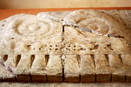
Poompuhar Art Gallery - Wikipedia
|
 |
| Poompuhar Beach - Wikipedia |
Kaveripoompattinam (காவிரிப்பூம்பட்டிணம்), also called various names from ancient times, Champathy (சம்பாதி) (as cited in Manimekalai (மணிமேகலை), Cholapattanam (சோழபட்டணம்), Kaveripattinam (காவேரிப்பட்டிணம்), Poompuhar (Pumpuhar) (பூம்புகார்), Puhar (புகார்), is the flourishing Sangam era international port town and estuary, located in Sirkali taluk (சீர்காழி வட்டம்), Nagapattinam district (நாகப்பட்டிணம் மாவட்டம்), Tamil Nadu, India PIN 609105. Puhar in Tamil means the ‘estuary’ i.e., place where Cauvery river (காவிரி ஆறு) enter into Bay of Bengal. This ancient coastline town served as the capital of early Chola rulers including Karikala Chola (கரிகால சோழன்), Sembian (செம்பியன்), Manu needhi Cholan (மனுநீதி சோழன்). Around 2nd century BC the the ships from Tamralipati (West Bengal), Palur (Orissa) anchored in the celebrated Kaveripoompattinam port before they sailed to Rome, Arabia and other Asian ports. The coastline town is .located 56 km towards North from district head quarters Nagapattinam and the near by cities are Karaikal (36 km), Mayiladuthurai (24 km), Parangipettai (24 km), Sirkali (21 km) and Tarangambadi (24 km).and 249 km from State capital Chennai The place is located in the border of the Nagapattinam district and Cuddalore district. Kaveripoompattinam, an archaeologist delight, lies on the geographical coordinates of 11.144°N and 79.855°E and the elevation / altitude is 6 m above sea level.
The coastline town is also famous for its great beach with calm surf from where you can witness the river Cauvery with its fresh water meeting the Bay of Bengal and the estuary is adjacent to the beach..If you have a passion for anything Sangam Tamil literature, history, Social life, Buddhism, fine arts, music, dance, drama, shipping, foreign trade and commerce, archaeological excavation, underwater archeology — you will find it here.
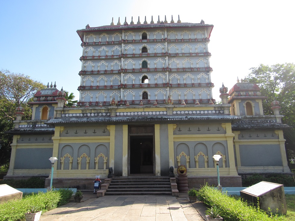
Poompuhar Beach is an ideal picnic spot. Silappadikaram Art Gallery is major tourist attraction and it is a classically built seven tiered architecture highlighting the history of the place, Underwater Archaeological Site Museum, an exclusive museum, was founded to showcase the antiquities recovered from under water exploration. It is the unique Museum in India. There are a number of temples located around Poompuhar. These include: Thiruppallavaneeswaram (near Poompuhar beach), Melapperumpallam and Keezhapperumpallam, Thirusaikkadu (Sayavanam) Chola temple with inscriptions. The coastline town is for those who like to wander amidst history and take a stroll through time. Indian tourism department provides shell shaped cottages for the tourists at a moderate tariff.
Poompuhar Beach is an ideal picnic spot. Silappadikaram Art Gallery is major tourist attraction and it is a classically built seven tiered architecture highlighting the history of the place, Underwater Archaeological Site Museum, an exclusive museum, was founded to showcase the antiquities recovered from under water exploration. It is the unique Museum in India. There are a number of temples located around Poompuhar. These include: Thiruppallavaneeswaram (near Poompuhar beach), Melapperumpallam and Keezhapperumpallam, Thirusaikkadu (Sayavanam) Chola temple with inscriptions. The coastline town is for those who like to wander amidst history and take a stroll through time. Indian tourism department provides shell shaped cottages for the tourists at a moderate tariff.
Glory of Chola Kings in Ancient Tamil Literary Works
Ancient Tamil Sangam literature such as Ahananuru (அகநானுறு), Purananuru (புறநானுறு), and Pattinappalai (பட்டினப்பாலை), and epics like Silappadikaram and Manimekalai (மணிமேகலை) details about this celebrated town. Musukunda Chakravarthy (முசுகுந்த சக்ரவர்த்தி), a mythological Chola king believed to have ruled Chola kingdom from Karur city. According to the legend Lord Indra sent a ghost (bhootha) to serve Musukunda Chakravarthy. The ghost served the king in the market place of Poompuhar town. The ghost would punish the citizens, if they fail to celebrate the Indra vizha (festival of Indra). "Thoongeyil Erinda Toditol" Sembian was a mythological Chola king who destroyed the fortress.
He is considered as one of the early Chola kings during Sangam period. He was instrumental in celebrating the Indra vizha in Kaveripoompattinam. There are numerous mentions about Karikala Chola (190 AD) in Tamil Sangam poetry.
The port town might have been enlarged during reign of king Karikala Chola. The Mahavamsa states that Ellalan (205 - 161 BC), a member of the Chola dynasty, ruled 'with even justice toward friend and foe, on occasions of disputes at law and got the title Manu Needhi Cholan (The Chola who follow Manu law). Thiruvalangadu copper plate traces the history of Chola race. Mentions about the Justice rendered by the king to the Cow.
Buddhist Connection
Buddhism spread to South India during Emperor Ashoka's reign. Arahat Mahinda (Mahendra) lead a group of Buddhist monks to Sri Lanks in 250 BC to spread Buddhism. Mahendra seems to have traveled by sea and on his way he stayed temporarily in Kaveripattinam. It is evident that seven Buddhist Viharas were erected at Kaveripattinam, by about 400 AD. Manimekalai refers Indra Viharam Ezhu which means seven viharas built by Indra. The Tamil Sangam works, Silappadikaram and Manimekalai attribute to Indra. Buddhist claim that the name Indra could be the contraction of Mahendra.
Buddhadatta Thera, a 5th century AD Theravada Buddhist scholar who hailed from Uragpura (modern Uraiyur, Tiruchirapalli, Tamil Nadu), went to Sri Lanka to study Buddhism in Mahavihara temple. This temple is believed to be the main seat of the ancestral branch for present day Theravada Buddhism in Sri Lanka founded by King Devananpiya Tissa..The monk also studied and translated the commentaries on the Buddha's teachings from Sinhalese to Pali. Buddhadatta Thera is said to have written most of his works in Kaveripattinam at the instance of the Buddhist acaryas Sumati, Buddhasika and Sanghapala. Buddhadatta's patron was the Chola king, Kalaber Accutavikkanta,
Bhadantacariya Buddhaghosa was a 5th-century Indian Theravada Buddhist commentator and scholar. The monk also translated a large body of Sinhala commentaries on the Pāli including Mahavamsa, a Sri Lankan chronicle, Buddhaghosuppatti, a later biographical work and Visuddhimagga. According to 'Chulavamsa', Buddhadatta and Buddhaghosa are certainly represented as contemporaries. Ghadhavansa, a Buddhist treatise mentions about ten famous Buddhist teachers in south of India, including Buddhadatta. Buddhadatta regards the Chola kingdom with respect and associate his literary activity with the reign of Accutavikkanata or Accutavikkama of the Kalabbha or Kalamba [kadamba] dynasty.
The Prakrit texts Abhidhammavatara and Buddhavamasattakatha written at Kveripattinam, by about 400 AD. attest to the flourishing nature of the port town, Milaidapana and Buddha Jataka also provide evidence for the prospering Chola port. According to Buddhist Jataka, one Akitti is said to have lived in a garden near Kaveripattinam.
Foreigners' Notes on Kaveripattinam
Periplus of the Erythraean Sea (Periplus Maris Erythraei), a work by an anonymous Alexandrian merchant, composed during the time of Domitian (81 – 96 AD), has provided brief information on the Chola country and its towns, ports and commerce. About half a century later Ptolemy, the renowned geographer brought out more information about Chola kingdom, its capital, ports and commerce.
Ascendance of Pallava Dynasty
Excavations at Poompuhar
In Indic mythology, Manimekala is a goddess regarded as a guardian of the seas. The epic Manimekalai vividly describes the Kaveripoompattinam. Indra Vizha (Annual Indra Festival) was a very popular festival in ancient Tamil Nadu according to twin Tamil epics Silappadikaram and Manimekalai. If Indra Vizha is not celebrated, goddess Manimekala would cause the wrath and the Town of Kaveripattinam would be swallowed up by the sea.
According to Manimekalai, the Chola king had lost his son. In a grip of grief the Chola king forgot to celebrate the Indra Vizha (Annual Indra Festival). Hence Kaveripattinam was swallowed up by the sea (destroyed by kadalkol - "swallowed by the sea.")
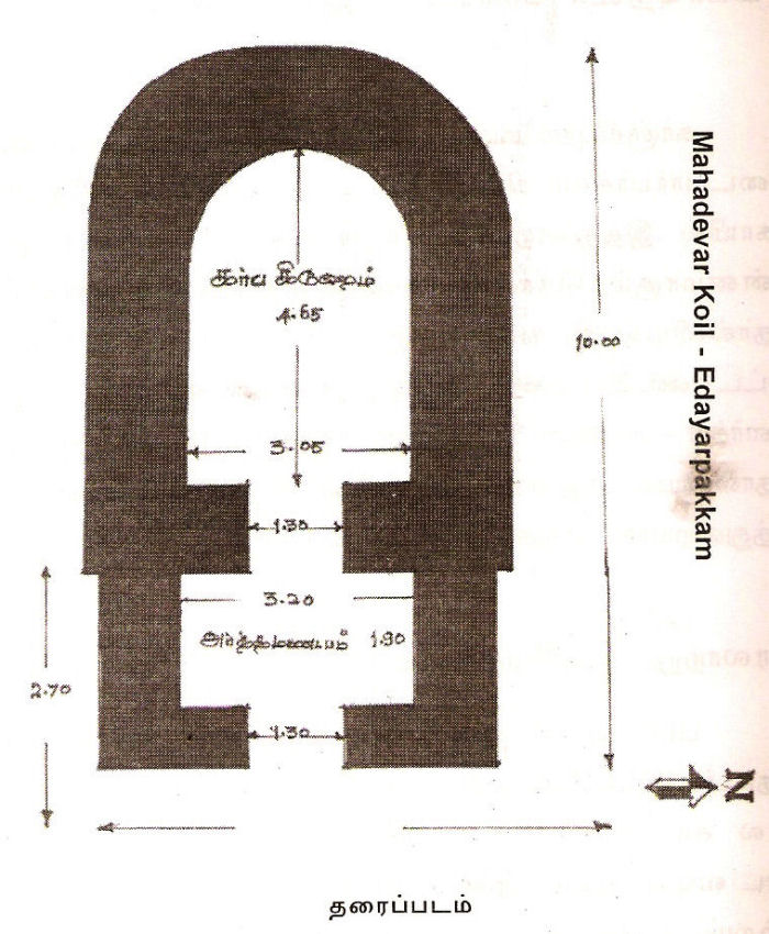
Temples
'Maya school of Town Planning and Architecture.'
Two Broad Divisions
Piffling traders, in an open street, sold baked sweet flour and fried flour-cakes; women sold toddy; various other traders include salt merchants, betel-leaf sellers, goat traders and oil merchants. There was also a meat market. Another adjacent street was full of bronze-smiths, copper-smiths, carpenters, strong armed black-smiths, gold-smiths who melt gold and those who make ornaments out of gold, Another part of the street occupied by tailors who stitch covers made of leather and different categories of skilled craftsmen produced handicrafts from cloth and pith. Another street inhabited by musicians with the ability to compose seven notes beginning with kural on wind instruments like flute and the stringed instruments like yazh. Also there were dwelling places of petty workers who earn their livelihood by serving others. Maruvurpakkam is the town populated by all these people.
Pattinappakkam
Elanchi Mandram (இலஞ்சி மன்றம்) is the square with the pool. Hunchbacks, the dwarfs, the dumbs, the deafs and the lepers who bathe in this pool are cured of their deformities and acquire attractive complexion. They then gratefully circumambulate the square.
Paavai Mandram (பாவை மன்றம்) is the place of justice and if injustice is done to 'Paavai' (idol) by people they would certainly shed tears.
Kotrappandal (கொற்றபந்தல்) was the ornamental shamiana presented by the king of the 'Vajra' country (வஜ்ர நாடு).
The town also had well laid out gardens like Elavanthikai Cholai (இலவந்திகை சோலை), Uyyavanam (உய்யவனம்), Champapathyvanam (சம்பாபதிவனம்) and Kaverivanam (காவேரி வானம்). Temples for Shiva, Chadukka Boodham, Indra, Balarama, Surya (Sun), Machathan, Chandra (Moon), Tirumal (Vishnu) and Arugan (Jain) where there besides Buddha stupa and seven Buddha Viharas, Champapathy Amman temple, brick idols and Ulagu Arivai Mandram (உலகு அரிவை மன்றம்).
A Buddhist vihara and a chaitya were also located in the area. Pattinappalai refers to people from various countries residing amicably at Puhar. Manimekalai refers to artisans from the Magadha, Avanti and Maratta countries.and also Greek sculptors Yavanat taccars working at Kaveripattinam.
How to get there?
தூங்கெயில் எறிந்த தொடிதோள் செம்பியன் (புறநானுறு Puranauru 39)
தூங்கு எயில் எறிந்த தொடி விளங்கு தடக்கை
நாடா நல்லிசை நற்றேர்ச் செம்பியன் (சிறுபாணாற்றுப்படை Cirupanarruppadai 74 - 75)
'பலர்புகழ் மூதார்ப் பண்புமேம் படீஇய
ஓங்குயர் மலயத் தருந்தவ அரைப்பத்
அாங்கெயி லெறிந்த தொடித்தோட் செம்பியன் ' (மணிமேகலை. Manimekalai 1)
He is considered as one of the early Chola kings during Sangam period. He was instrumental in celebrating the Indra vizha in Kaveripoompattinam. There are numerous mentions about Karikala Chola (190 AD) in Tamil Sangam poetry.
நளியிரு முன்னீர் நாவாய் ஒட்டி
வளிதொழில் கண்ட உரவோன் மருக!
களிஇயல் யானை கரிகால் வளவ!
(புறநானுறு Puranauru 68)
பெருவளக் கரிகால் (அகநானூறு Ahananuru, 125: 18)
பெருவளக் கரிகால் முன்னிலைச் செல்லார் (அகநானூறு Ahananuru 125)
கரிகால் வளவனொடு வெண்ணிப் பறந்தலைப்
பொருது புண் நாணிய சேரலாதன் (அகநானூறு, Ahananuru 55: 10-11)
உருவப் பஃறேர் இளையோன் சிறுவன்
தாய்வயிற் றிருந்து தாயம் எய்தி (பொருநராற்றுப்படை Porunarruppadai: 130,132)
‘விண்பொரு பெரும்புகழ் கரிகால் வளவன் (சிலப்பதிகாரம். காதை Silappadikaram Kadhai 6, 160)
The port town might have been enlarged during reign of king Karikala Chola. The Mahavamsa states that Ellalan (205 - 161 BC), a member of the Chola dynasty, ruled 'with even justice toward friend and foe, on occasions of disputes at law and got the title Manu Needhi Cholan (The Chola who follow Manu law). Thiruvalangadu copper plate traces the history of Chola race. Mentions about the Justice rendered by the king to the Cow.
Buddhism spread to South India during Emperor Ashoka's reign. Arahat Mahinda (Mahendra) lead a group of Buddhist monks to Sri Lanks in 250 BC to spread Buddhism. Mahendra seems to have traveled by sea and on his way he stayed temporarily in Kaveripattinam. It is evident that seven Buddhist Viharas were erected at Kaveripattinam, by about 400 AD. Manimekalai refers Indra Viharam Ezhu which means seven viharas built by Indra. The Tamil Sangam works, Silappadikaram and Manimekalai attribute to Indra. Buddhist claim that the name Indra could be the contraction of Mahendra.
Buddhadatta Thera, a 5th century AD Theravada Buddhist scholar who hailed from Uragpura (modern Uraiyur, Tiruchirapalli, Tamil Nadu), went to Sri Lanka to study Buddhism in Mahavihara temple. This temple is believed to be the main seat of the ancestral branch for present day Theravada Buddhism in Sri Lanka founded by King Devananpiya Tissa..The monk also studied and translated the commentaries on the Buddha's teachings from Sinhalese to Pali. Buddhadatta Thera is said to have written most of his works in Kaveripattinam at the instance of the Buddhist acaryas Sumati, Buddhasika and Sanghapala. Buddhadatta's patron was the Chola king, Kalaber Accutavikkanta,
Bhadantacariya Buddhaghosa was a 5th-century Indian Theravada Buddhist commentator and scholar. The monk also translated a large body of Sinhala commentaries on the Pāli including Mahavamsa, a Sri Lankan chronicle, Buddhaghosuppatti, a later biographical work and Visuddhimagga. According to 'Chulavamsa', Buddhadatta and Buddhaghosa are certainly represented as contemporaries. Ghadhavansa, a Buddhist treatise mentions about ten famous Buddhist teachers in south of India, including Buddhadatta. Buddhadatta regards the Chola kingdom with respect and associate his literary activity with the reign of Accutavikkanata or Accutavikkama of the Kalabbha or Kalamba [kadamba] dynasty.
The Prakrit texts Abhidhammavatara and Buddhavamasattakatha written at Kveripattinam, by about 400 AD. attest to the flourishing nature of the port town, Milaidapana and Buddha Jataka also provide evidence for the prospering Chola port. According to Buddhist Jataka, one Akitti is said to have lived in a garden near Kaveripattinam.
Foreigners' Notes on Kaveripattinam
Periplus of the Erythraean Sea (Periplus Maris Erythraei), a work by an anonymous Alexandrian merchant, composed during the time of Domitian (81 – 96 AD), has provided brief information on the Chola country and its towns, ports and commerce. About half a century later Ptolemy, the renowned geographer brought out more information about Chola kingdom, its capital, ports and commerce.
Inscription
The earliest reference to Kaveripoompattinam is noticed in a Prakrit inscription of 2nd century BC found at Bharhut in the Satna district of Madhya Pradesh, India. The Bharhut stupa is believed to have been first built by the Maurya emperor Ashoka in the 3rd century BC, However many works of art were apparently added during the Shunga period. The Bharhut inscriptions are viewed with the considerable significance because they trace the history of early Indian Buddhism and Buddhist art.
The inscription refers to the gift of a stone slab for an enclosure of a stupa by a Buddhist nun called Soma, who hailed from the city Kakandi Kakandi according to Manimekalai was one of the names of Kaveripattinam. The gift of slab by the Buddhist nun Soma of Kakandi, as early as 2nd century BC, shows that Kaveripattinam was a flourishing town and that it served as an important Buddhist centre till at least 8th century AD.
kakandiya somaya bichuniya danam (காகந்தியா சோமாய பிச்சுனியா தானம் ) (Corpus Inscriptorum Indicarum Vol. II Part II)
Ascendance of Pallava Dynasty
Pallavas slowly extended their power to the south and Kaveripattinam was included in the Pallava territory. The temple Pallavanisvaram should have been built sometime in the beginning of 6th century AD. by a Pallava monarch, whose name is not known. In the reign of Rakasimha a Buddha vihara is said to have been erected at Nagapattinam.
In Indic mythology, Manimekala is a goddess regarded as a guardian of the seas. The epic Manimekalai vividly describes the Kaveripoompattinam. Indra Vizha (Annual Indra Festival) was a very popular festival in ancient Tamil Nadu according to twin Tamil epics Silappadikaram and Manimekalai. If Indra Vizha is not celebrated, goddess Manimekala would cause the wrath and the Town of Kaveripattinam would be swallowed up by the sea.
“தீவகச் சாந்தி செய்யா நாள்உன்
காவல் மாநகர் கடல்வயிறு புகூஉம்” (மணிமேகலை: 24:62-63)
“மணிமேகலா தெய்வம் மற்றது பொறாஅல்
அணிநகர் தன்னை அலைகடல் கொள்கென
விட்டனள் சாபம் பட்டதிதுவால்
கடவுள் மாநகர் கடல்கொள” (மணிமேகலை 25:198-201)
Literary works and archaeological evidence suggest repeated Tsunami, sea incursions, erosion and floods in Kaveripattinam. The Sea submerged the original city and at present there is only a small village. Thirusaikadu or Sayavanam, Pallavanisvaram, Melapperumpallam, Keelaperumpallam, Keezaiyur and Vanagiri are the remains of ancient Poompuhar that exist today.
 |
| Under water Excavation PC Tamizharsenai |
 |
| 11000 Years Old U Shaped Structure Graham Hancock |
 |
| Under-water Excavations in Poompuhar. |
Under-sea Exploration was conducted by the State Department of Archeology in collaboration with the National Institute of Oceanography (NIO), Goa, India during 1990 - 94 and 1997. The under sea archaeological explorations around Poompuhar throws light on the remains of terracotta ring wells, brick structures and lead ingots.
The team also discovered storage jars in the inter tidal zone and brick structures, stone structures, pottery from offshore explorations. Few references also suggest the shift of shoreline at Poompuhar and Tranquebar and that could be one of the reasons of its submergence. Under-sea Exploration resulted in a site museum.
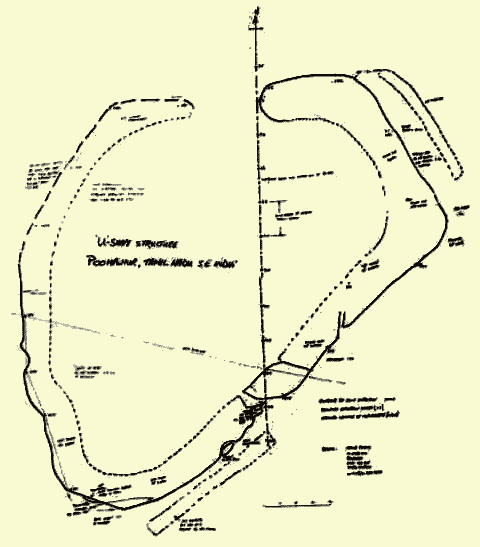
Graham Hancock, a British marine archaeologist and author was involved in examining a submerged city on the East Coast of Tamil Nadu. According to Hancock, the civilization thriving in Poompuhar may predate the Sumerian civilization of Mesopotamia (present-day Iraq) and could certainly existed before the Harappan civilization in India and Pakistan. He also added that his underwater explorations conducted in 2001 provided strong evidence that corroborated Tamil mythological stories of ancient floods. He also ascertained that the tidal waves of 400 feet or more could have swallowed this flourishing port city any time between 17,000 and 7,000 years ago. His conclusion is that "the Poompuhar underwater site could well provide evidence that it was the cradle of modern civilization." Theory of this British marine archaeologist strengthened the findings of India's National Institute of Oceanography (NIO). The U-shaped structure gleaned during the joint SES/NIO (Hancock ) expedition is shown below.
The team also discovered storage jars in the inter tidal zone and brick structures, stone structures, pottery from offshore explorations. Few references also suggest the shift of shoreline at Poompuhar and Tranquebar and that could be one of the reasons of its submergence. Under-sea Exploration resulted in a site museum.
Graham Hancock, a British marine archaeologist and author was involved in examining a submerged city on the East Coast of Tamil Nadu. According to Hancock, the civilization thriving in Poompuhar may predate the Sumerian civilization of Mesopotamia (present-day Iraq) and could certainly existed before the Harappan civilization in India and Pakistan. He also added that his underwater explorations conducted in 2001 provided strong evidence that corroborated Tamil mythological stories of ancient floods. He also ascertained that the tidal waves of 400 feet or more could have swallowed this flourishing port city any time between 17,000 and 7,000 years ago. His conclusion is that "the Poompuhar underwater site could well provide evidence that it was the cradle of modern civilization." Theory of this British marine archaeologist strengthened the findings of India's National Institute of Oceanography (NIO). The U-shaped structure gleaned during the joint SES/NIO (Hancock ) expedition is shown below.
 |
| Marine Archaeological Museum. State Department of Archeology Tamil Nadu |
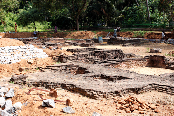
Off-shore explorations were carried out near Champapathi Amman and Pallavanisvaram temples, Poompuhar right from 1910. During the excavations remains of the various buildings were found:
The site of Buddha Vihara (brick structure) dated 4th - 5th century AD. at Pallavanisvaram, near Kaveripoompattinam, was excavated by the ASI and it is established that the ruins formed part of Kaveripoompattinam. The ancient Buddha vihara was built with burnt bricks (of different dimensions) and they have used mud mortar as the binding material. For the basement they used bricks with 36.25 x 18.75 x 7.5 cm size bricks and for superstructure they have used 23.75 x 12,5 x 5 cm size bricks. ASI also discovered a Buddha statue, and Buddhapada (dimension: 3 1/2' x 2 1/2' ) or the feet of Lord Buddha in limestone at this site.
Manigramam is a village in Nagapattinam district, Tamil Nadu. It is located 5 km from Poompuhar. Famous Thirumani Azhagar temple is located in this village. Tamil Nadu Department of Archeology team excavated in 95 two intact portions of a brick wall as well as the collapsed structure dating between 3rd century B.C. and 2nd century AD.
Two brick walls running Northeast-Southwest at a depth of 20 cm was discovered in Kilayur (Kizharveli). They have also used mud mortar as the binding material. The structure is considered to have served as a wharf in the 4th century AD. ASI has observed four wooden poles - two palmyra tree trunks and two Iluppai (Bassia Longifolia) tree trunks - were used for this wharf.
A wharf belonging to the 3rd century BC was excavated at Poompuhar in 1962-63 and a similar wharf was unearthed in the subsequent excavation during 1997. Several kinds of brick figures and copper coins were also found.
 |
Wharf Unearthed near Poompuhar. PC TN State Arch
|
 |
| Excavated Site with Exposed Structure & Ring well @ Poompuhar PC Indianetzone |
 |
| Terracota Marine Archaeological Museum PC Dept TN State Arch |
 |
| Buddha Monastery. Pallavanesvram PC Panoramio |
 |
| Buddha Monastery. Pallavanesvram PC Sharon St Joan |
 |
| Buddha Feet |
A wharf belonging to the 3rd century BC was excavated at Poompuhar in 1962-63 and a similar wharf was unearthed in the subsequent excavation during 1997. Several kinds of brick figures and copper coins were also found.
City Layout
The structure of Poompuhar town can be traced from the fifth chapter of the Silappadikaram, Pattinappalai. Manimekalai also describes the same. Pattinappalai is one of the poem in the Sangam anthology of longer poems, the Ten Idylls (Patthupattu). Poet Katiyalur Uruttiran Kannanar vividly captures the glories and splendour of Kaveripoompattinam and its king Tirumavalavan a.k.a Karikala Cholan. The poem is categorized into three segments. Segment one, comprising 218 lines, details the fertility, prosperity and affluence of the great town Poompuhar. The segment also provides an account of the perennial flow of water in the holy river Cauvery in Chola kingdom, bewildering wealth, the layout of the city, the harbor, the custom-house, and the life of various people belonging different occupations. The second segment is about the life and achievements of the king Tirumavalavan. The third segment deals with poetic theme pertaining to 'Palai'
The five Manrams - Vellidai Manram, Elanchi Manram, Nedankal mandram, Bootha-chathukkam and Pavaimanram were located in Pattinappakkam. Gardens like Elavanthikaicholai, Uyyavanam, Champathivanam, and Kaveravanam added beauty to the town.
Symbolical Monuments Reproduced
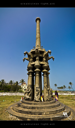
In 1973 Kalaingar Dr.M.Karunanithi the Honoruable Chief Minister of Tamil Nadu gave crystal form to the lost town,by reproducing it on the basis of literary evidences. Several Symbolical monuments were raised. Sillappadikaram-Art gallery, Elanchi Mandram, Pavai Mandram, Nedungal Mandram and Kotrappandal found their existence and remain today, to attract visitors, with their artistic splendor.
Temples
During excavations, temples for Lord Shiva, and Chathukka Bootham, the last of the deities were found in the city. There are temples for Shiva, Indra, his elephant Iravatham, and his Vajrayutham, Balaraman, Suriyan, Machatham, Chandran, Arugan and Thirumal. Buddha stupas or pillars and seven Buddha viharas were also found. Apart from these, a temple for Champapathi Amman, brick idols, and Ulaga Aravi Manram existed in Poompuhar.
'Maya school of Town Planning and Architecture.'
Silappadikaram elaborates the town planning of Kaveripoompattinam including its avenues, streets, mansions, residences of foreign merchants groves, gardens, market places, petty traders and workshops, It was an excellent example of town planning during 100 BC with well laid streets occupied by Yavana sailors and overseas traders, weavers, silk traders, grain merchants, jewelers and precision gems makers and petty traders, According Pattinappalai, Silappadikaram and Manimekalai, the town planning followed the 'Maya school of Town Planning and Architecture.'
Two Broad Divisions
From the description of these ancient Tamil literature Kaveripoompattinam was laid out on the north banks of the river Cauvery and was divided into two broad divisions i.e., Maruvurpakkam near the sea-shore and Pattiinappakkam to its west. A market place was located, under shady trees, in between the two divisions. The day market was known as 'Nalangadi' and the night market was named as "Allangadi.' Pakkam means a place adjacent to the sea-shore or hillock. Here pakkam signifies the place by the side of the sea-shore. Greeks (Yavanars) and other merchants from foreign countries resided in the outskirts of Maruvurpakkam and carried their business.
பயன றவறியா யவன ரிருக்கை
(Silappadikaram Indra Vizhavu Ur Edutha Kadhai 10)
நீரின் வந்த நிமிர்பரிப் புரவியும்
காலின் வந்த கருங்கறி மூடையும்
வடமலைப் பிறந்த மணியும் பொன்னும்
குடமலைப் பிறந்த ஆரமும் அகிலும்
தென்கடல் முத்துங் குணகடல் துகிரும்
(Pattinappalai 1. 185 - 189)
|
At the limits of this prosperous town
The majestic horses arrive by land.
From the northern range comes gems and
gold;
Akil and sandal from western ghats,
And pearls from the southern seas are
heaped,
And corals from eastern waves;
|
Maruvurpakkam was populated by the fishermen. The settlements of foreign (Yavanar) merchants had terraced mansions, granaries and warehouses with windows shaped like the eyes of the deer and they have chosen to live closer to the sea-coast and to the ship-yard. Their presence nearer to the ship-yard enabled the Chola Customs Officials to collect duties from them and to affix the Customs Seal (Tiger Mark) on the imported goods. The Customs Officials will not permit the removal of the imported goods from the dockyard until they remit the appropriate Customs Duty.
நீரினின்று நிலத்தேறவு,
நிலத்தினின்று நீர்ப்பரப்பவு,
மலந்தறியாப் பலபண்டம்,
வரம்பறியாமை வந்தீண்டி,
யருங்கடிப் பெருங்காப்பின்,
வலியுடை வல்லணங்கினோன்,
புலிபொறித்துப் புறம்போக்கி,
(Patiinappalai 1. 129 - 136)
|
On mountain slopes, that flows down
plains
And rushes to merge with surging waves,
The countless cargoes from the land
Are shifted to the ships in the sea;
And loads and loads of cargoes there,
Quite varied beyond conceptual mind
Are moved to the land from the anchored
ships
And piled up there in heaps and heaps.
In the custom-house that's to enter
hard,
The ensign, a terror to thieves around
Stamp the royal Chola's sign
Of tiger on every piece before
It crosses the line of custom-house.
|
The streets next to the quarters occupied by the Yavanars or the foreign merchants were occupied by wandering pedlar selling colored pastes, unguents, fragrant sandal, flowers, eaglewood and perfumes. Weavers who worked on silk, fur and cotton thread resided in adjacent streets. Heaps of silks, corals, sandal, eaglewood, flawless pears, gems, gold and other precious articles were sold in broad streets. Grain markets ,adjacent to broad street, sold different kinds of grains and pulses exhibited in separate heaps.
வளந்தலை மயங்கிய நனந்தலை மறுகும்
(Silappadikaram Indra Vizhavu Ur Edutha Kadhai 21)
Piffling traders, in an open street, sold baked sweet flour and fried flour-cakes; women sold toddy; various other traders include salt merchants, betel-leaf sellers, goat traders and oil merchants. There was also a meat market. Another adjacent street was full of bronze-smiths, copper-smiths, carpenters, strong armed black-smiths, gold-smiths who melt gold and those who make ornaments out of gold, Another part of the street occupied by tailors who stitch covers made of leather and different categories of skilled craftsmen produced handicrafts from cloth and pith. Another street inhabited by musicians with the ability to compose seven notes beginning with kural on wind instruments like flute and the stringed instruments like yazh. Also there were dwelling places of petty workers who earn their livelihood by serving others. Maruvurpakkam is the town populated by all these people.
சிறுகுறுங் கைவினைப் பிறர்வினை யாளரொடு
மறுவின்றி விளங்கும் மருவூர்ப் பாக்கமும
(Silappadikaram Indra Vizhavu Ur Edutha Kadhai 38-39)
Pattinappakkam
The palace of the king is located in Pattinappakkam (பட்டினப்பாக்கம்) and the King's (Raja) street was the main highway here (கோவியன் வீதியும், கொடித்தேர் வீதியும்). A few stalls in a bazaar street near the palace sold the ordinary necessities. The leading merchants, the pious brahmins, thrifty farmers, the ayurvedic physicians and the astrologers (ஆயுள் வேதரும் காலக் கணிதரும்) dwell in independent streets in different types of houses appropriate to each class of people, the various designs presenting by contrast a picturesque sight.
People who made bangles and rings out of conch-shells, and pearl bead sellers lived in parallel streets on the western side of the palace. The king's retinue and courtiers lived in broad streets within reach of the palace. The Sootars (சூதர்) or those who stand and praise, the Makadars (மாகதர்) or those who sit and praise, the time reckoners (நாழிகைக் கணக்கர்), and the dancers (santhi-koothar) lived in various streets near the palace.
People who made bangles and rings out of conch-shells, and pearl bead sellers lived in parallel streets on the western side of the palace. The king's retinue and courtiers lived in broad streets within reach of the palace. The Sootars (சூதர்) or those who stand and praise, the Makadars (மாகதர்) or those who sit and praise, the time reckoners (நாழிகைக் கணக்கர்), and the dancers (santhi-koothar) lived in various streets near the palace.
சூதர் மாகதர் வேதா ளிகரொடு
நாழிகைக் கணக்கர் நலம்பெறு கண்ணுளர்
காவல் கணிகையர் ஆடல் கூத்தியர்
The cooks, musicians, the drummers in festivals and on the battle-field and buffoons (நகைவேழம்பர்) lived in houses of various types and dimensions suitable to their calling and circumstance.
நகைவே ழம்பரொடு வகைதெரி இருக்கையும்,
Beyond these streets where servants of royal household had their respective quarters, were the residences of those who trained horses and elephants. The open spaces where the horses were trained for military purposes are known as Cenduveli (செண்டுவெளி). This was the Pattina-p-pakkam or the urban portion of the city.
Between Maruvurpakkam and Pattinappakkam there was a large open area where the day-market (நாளங்காடி) was centrally situated in a site which presented the appearance of a vast plain between two opposing forces. In the market there were stalls for selling a variety of goods. Each stall floated a flag announcing the name of the article sold therein. The trees around provided cool shade and breeze.
இருபெரு வேந்தர் முனையிடம் போல
இருபால் பகுதியின் இடைநிலம் ஆகிய
கடைகால் யாத்த மிடைமரச் சோலை (59 - 61)
In the centre of the area set apart for the market and where the main streets intersected, there was a temple dedicated to Chathukka Bootham (சதுக்கபூதம்), the Guardian Deity of the city.
 |
| Chathukka Bootham Wikipedia |
Vellidai Mandram (வெள்ளிடை மன்றம்) is the square with the open space was used as warehouse stored with packages showing the names, symbols and the nature of the merchandise contained in them and the names of the owners. The place is neither guarded by the watch at the gates nor iron bolts on the door. Stealing a package would be very difficult.
Elanchi Mandram (இலஞ்சி மன்றம்) is the square with the pool. Hunchbacks, the dwarfs, the dumbs, the deafs and the lepers who bathe in this pool are cured of their deformities and acquire attractive complexion. They then gratefully circumambulate the square.
 |
| Nedungal Mandram PC Flickriver |
Nedungal Mandram (நெடுங்கல் மன்றம்) is the square with the tall and bright stone pillar. People drugged to madness by enemies; those who have consumed poisonous food and shiver due to pain; those who are suffering from snake bite; and those who suffer under the influence of devils would go around the stone pillar and worship it in order to get cured from the afflictions.
Paavai Mandram (பாவை மன்றம்) is the place of justice and if injustice is done to 'Paavai' (idol) by people they would certainly shed tears.
Kotrappandal (கொற்றபந்தல்) was the ornamental shamiana presented by the king of the 'Vajra' country (வஜ்ர நாடு).
The town also had well laid out gardens like Elavanthikai Cholai (இலவந்திகை சோலை), Uyyavanam (உய்யவனம்), Champapathyvanam (சம்பாபதிவனம்) and Kaverivanam (காவேரி வானம்). Temples for Shiva, Chadukka Boodham, Indra, Balarama, Surya (Sun), Machathan, Chandra (Moon), Tirumal (Vishnu) and Arugan (Jain) where there besides Buddha stupa and seven Buddha Viharas, Champapathy Amman temple, brick idols and Ulagu Arivai Mandram (உலகு அரிவை மன்றம்).
A Buddhist vihara and a chaitya were also located in the area. Pattinappalai refers to people from various countries residing amicably at Puhar. Manimekalai refers to artisans from the Magadha, Avanti and Maratta countries.and also Greek sculptors Yavanat taccars working at Kaveripattinam.
How to get there?
By Road
Kaveripoompattinam is well-connected to a number of neighboring towns by network of roads Sirkali (21 km) and Mayiladuthurai (23.7 Km).
Kaveripoompattinam is well-connected to a number of neighboring towns by network of roads Sirkali (21 km) and Mayiladuthurai (23.7 Km).
By Rail
Sirkali (21 km) and Vaithisvaran kovil (17 km), Mayiladuturai (23.7 km) Railway Stations are the very nearby railway stations. However Thanjavur Railway Station is major railway station 92 km near to Kaveripoompattinam
By Air
Near by Airports: Chennai Airport ( 226 km), Madurai Airport (265 km)
Reference
- ASI set up centre to showcase relics of ancient port city. Times of India. March 25, 2009.
- Buddhadatta Wikipedia
- Gaur A. S. and Sundaresh, Underwater Exploration off Poompuhar and possible causes of its Submergence, 1998, Puratattva, 28: 84-90.
- Glad Tidings: The Lost City Poompuhar. Peepal Prodigy School. (http://www.peepalprodigy.com/glad-tidings-the-lost-city-poompuhar/)
- History of Poompuhar. Archaeological Excavations. Blogspot. January 11, 2011 (http://archaeologyexcavations.blogspot.in/2011/01/history-of-poompuhar.html?m=1)
- Indian history: What is the history behind Poompuhar in Indian history? Quora. (https://www.quora.com/Indian-history-What-is-the-history-behind-Poompuhar-in-Indian-history)
- Inside Story: In search of a lost city. Lakshmi Sharath. The Hindu Metroplus. October 7, 2011 (http://www.thehindu.com/features/metroplus/inside-story-in-search-of-a-lost-city/article2517975.ece)
- Kaveripoompattinam (http://210.212.62.26/pdf_files/books/Kaveripoompattinam.pdf)
- Pattinappalai ( A Note on Poem & Translation ) by Devendran B. International Institute of Tamil Studies. 068 - December 2005 (http://www.ulakaththamizh.org/JOTSArticle.aspx?id=558)
- Poompuhar-Ancient Chola city in Tamil Nadu, India,Kumari Kundam. Hinduism and Sanadan Dharma. April 5, 2015. (https://pparihar.com/2015/04/05/poompuhar-ancient-chola-city-in-tamil-naduindiakumari-kundam/)
- Poompuhar. Department of Archaeology. (http://www.tnarch.gov.in/excavation/poo.htm)
- Poompuhar. Tamil Nadu Tourism. (http://www.tamilnadutourism.org/places/citiestowns/Poompuhar.aspx)
- South India and Buddhagosa. Buddhagosa. August, 18, 2010 (http://ghosagvp.blogspot.in/2010_08_01_archive.html)
- Tourism in Poompuhar Tourism of India (http://www.tourism-of-india.com/poompuhar-tour/)
- பட்டினப்பாலை. கடியலூர் உருத்திரங் கண்ணனார் Project Madurai. (http://www.projectmadurai.org/pm_etexts/utf8/pmuni0077.html)
- சதுக்கபூதம் Wikipedia
YouTube