Showing posts with label Architecture. Show all posts

Saturday, November 19, 2016

Edayarpakkam Mahadevar Temple: Granite Structural Temple near Kanchipuram, Tamil Nadu


Mahadevar Koil, Edaiyarpakkam
_MG_0878.jpg (1600×1067)
Varalaru.com

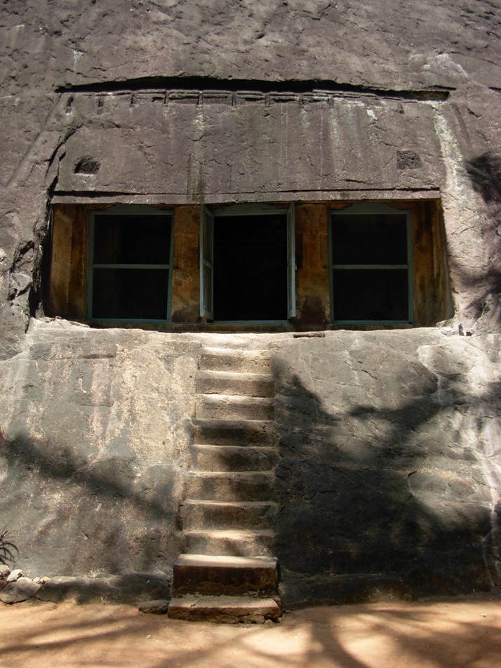
Apsidal shape back view
Idayarpakkam_ShivaTemple+%2814%29.JPG (913×1486)
Idayarpakkam_ShivaTemple+%2816%29.JPG (851×1600)

Idayarpakkam_ShivaTemple+%2810%29.JPG (240×320)

Mahadevar Temple is located in Edayarpakkam village, Sriperumbudur taluk, Kanchipuram district, Tamil Nadu, India PIN 631553. The temple is located 22 km towards North from district head quarters Kanchipuram; 19 km from Sriperumbudur; 12.5 km from Sunguvarchatram; 9.1 km from Thakkolam; 6.1 km from Arakkonam;  0.2 km from Elmyankottur; and 58 km from the state capital Chennai. This place is in the border of the Kanchipuram district and Thiruvallur district.  The temple is protected by ASI.

The Chola period Mahadevar shrine is apsidal  (horseshoe-shaped) dvitala (two tiered) vimana and an ardha-mandapam (அர்த்த-மண்டபம்). Therefore the vimana is called gajaprishta (கஜபிருஷ்ட விமானம்) or hastiprishta (ஹஸ்திபிருஷட விமானம்), both terms in Sanskrit meaning ‘back of an elephant’ as it is curved at the rear. According to dictionary.com the word 'apse'  means a semicircular or polygonal termination or recess in a building.  

According to most historians the apsidal form of vimana is of Buddhist origin. However current studies have confirmed that the apsidal vimana architecture was attempted by pan-Indian-tradition and the style was in existence much before the Buddhist era. This form of vimana is found in few other Chola temples in and around Chennai.

StructuralTemple-Pallava-Idayarpakkam-03.jpg (700×850)

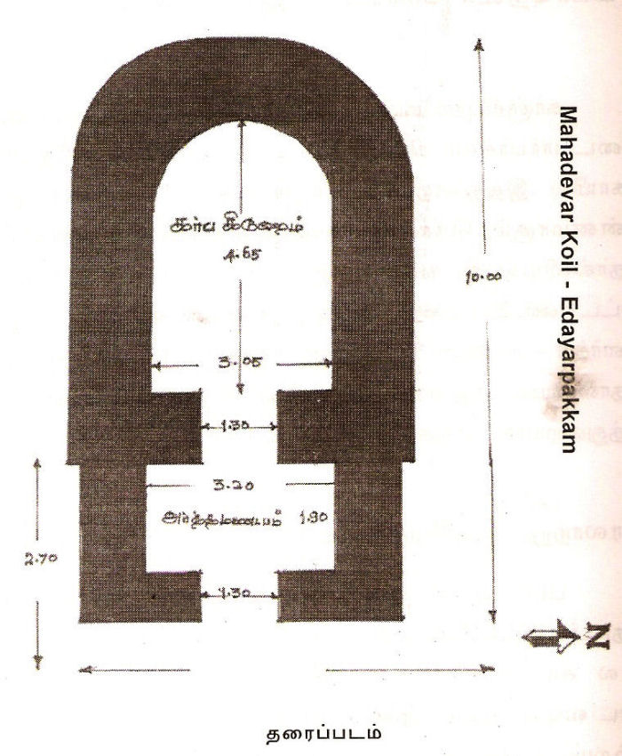
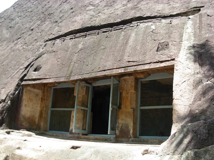
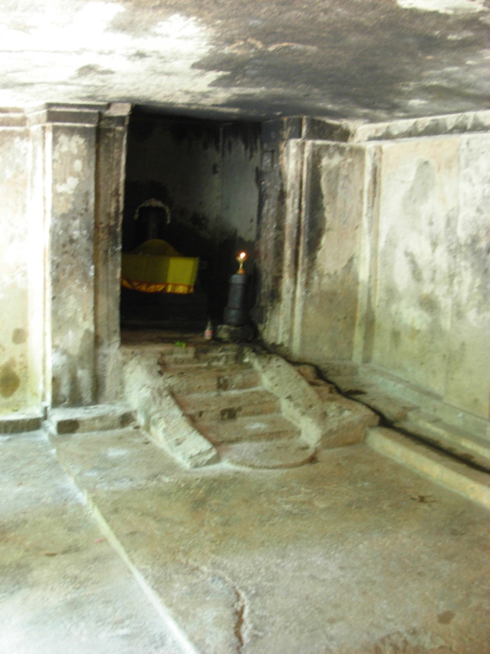
The entire temple structure is made out of granite and therefore it is a 'katrali' (கற்றளி). The vimana and ardhamandapam stands on a molded pada-bandha adishtana (பாதபந்த அதிஷ்டானா) with upa-peeta (உப பீடம்), jagadi (ஜகதி), tripatta kumuda (முப்பட்டைக் குமுதம்), khanta (கண்டம்) with pada and flanked by kampa (கம்பு) and pattika (பட்டிகை) mouldings. The east facing sanctum measures 3.05 m in width in the north-south direction and 4.65 m in length in the east-west direction. The sanctum entrance is 1.35 cm in width. The sanctum houses "Tiruppadakkadu udaiya Mahadevar" (திருப்படக்காடுடைய மகாதேவர்) in the form of Shivalingam.

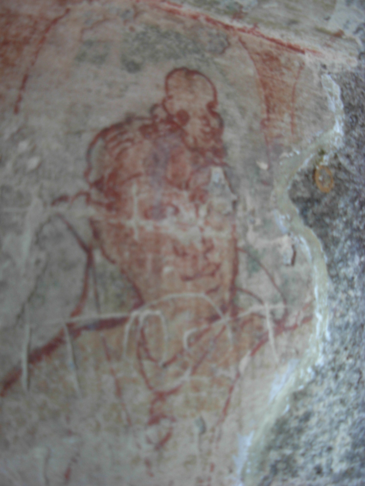
The external walls of the vimana and ardhamandapam have five deeply cut niches (தேவகோட்டங்கள்) flanked by ornate square pilasters (அரைத்தூண்கள்). The niches on the south and north ardhamandapa walls houses the Chola style idols of Vinayaka and Durga respectively. The southern vimana wall houses the sanctum of the unique Dakshinamurthy appear seated on a pedestal under the Kallala tree (Banyan tree). The niche of the western vimana wall is empty. Brahma appear in the niche of the northern vimana wall.

Above the pilasters is the vettu potika holding the uttira. And the other roof parts are the vajana valabhi and kapota with rough kudu arches. Above the kapota is the bhumidesa denoting the end of the tala. Above the bhumidesa is seen the hara of the first tala. The hara components of second tala as well as griva, shikara and stupa (finial) might have got damaged and therefore not found at present.

Inscriptions

There are four inscriptions belonging to the later Chola period, especially that of Kulottunga Chola I (1070 - 1120 A.D.),  Kulottunga Chola II (1133 - 1150 A.D.) and Rajadhiraja Chola II (1163 - 1178) are found at Edayarpakkam Mahadevar temple near Kanchipuram. The inscription (ARE 251/1910), (த நா அ தொ து 524/2013) dated 13th in the reign (year 1083 A.D.) of king Kulottunga Chola I opening with his venerated Prasasti (also known as Meikeerthi மெய்க்கீர்த்தி) is considered as the earliest inscription in this temple.

Inscriptions mention the prime deity of the temple as "Tiruppadakkadu udaiya Mahadevar" (திருப்படக்காடுடைய மகாதேவர்) as well as "Aludaiyar Tiruppadakkadu udaiyar" (ஆளுடையார் திருப்படக்காடுடையார்).

Inscriptions cite the name of this village as "Edayarruppakkam" (இடையாற்றுப்பாக்கம்). Present name seems to have transitioned from Edayarruppakkam to Edayarpakkam. Edayarruppakkam village fell under the revenue division of Purisai Nadu (புரிசை நாடு), which was a sub-division of Manavir-kottam (மணவிற் கோட்டம்) under the larger division of Jayamkonda Cholamandalam (ஜெயங்கொண்ட சோழமண்டலம்). (ஜெயங்கொண்ட சோழமண்டலத்து மணவிற்கோட்டத்துப் புரிசை நாட்டு இடையாற்றுப்பாக்கம்). The village was also known as Purisai (புரிசை) village fell under the same revenue division, part of same sub-division and coming under the same larger division (ஜெயங்கொண்ட சோழமண்டலத்து மணவிற்கோட்டத்துப் புரிசைநாட்டுப் புரிசை).  The village was also popularly known as Rajavichadira Chaturvedi Mangalam (ராஜவிச்சாதிர சதுர்வேதிமங்கலம்).

The inscription (ARE 251/1910), (த நா அ தொ து 524/2013) is dated 13th in the reign (year 1083 A.D.) of king Kulottunga Chola I. It opens with his venerated Prasasti also known as Meikeerthi (மெய்க்கீர்த்தி). It records the gift of land as devadana (தேவதானம்) to Tiruppadakkadu udaiya Mahadevar by one Arurudaiyan Vaidyanatan Tiruchcirrambalamudaiyan in Kilar-kurram, a sub-division of Nittavinoda-valanadu of Chola Mandalam.
(3 .. ... ஜயங்கொண்ட  சோழ மண்டலத்து மணவிற்கோட்டத்து ... சோழமண்டலத்து நித்த விநோத வளநாட்டுக் கிழாற் கூற்றத்து
4 .த்தங்குடி  ஆரூர்ருடையாந் வைத்யநாதன் திருச்சீற்றம்பல முடையான் ...  .)

The inscription (த நா அ தொ து 523/2013) is dated 13th in the reign (year 1107 A.D.) of king Kulottunga Chola I. It commences with his venerated Prasasti also known as Meikeerthi (மெய்க்கீர்த்தி). It records the gift of 95 sheep (சாவா மூவா பேராடு தொண்ணூற்றைந்து) for a perpetual lamps for the Lord Tiruppadakkadu udaiya Mahadevar at Purisai in Purisai Nadu, a sub-division of Manavir-kottam by Velan Madurantakan, the head man of Arasur, in Koneri-nadu in the Eyirk-kottam. (3 ... இம்மண்டலத்து எயிற்கோட்டத்துக் கோநேரி நாட்டுக் கோநேரியில் அரசூர்
 கிழவந் வேளாந் மதுராந்தகநேன் ....  )  

The inscription (ARE 254/1910), (த நா அ தொ து 525/2013) is dated 12th in the reign (year 1145 A.D.) of king Kulottunga Chola II. It commences with his venerated Prasasti also known as Meikeerthi (மெய்க்கீர்த்தி). It records the gift of land purchased from the urar (ஊரார்) of Purisai, for a lamp to the temple of Aludaiyar Tiruppadakkadu udaiyar at Idaiyarruppakkam (இடையாற்றுப்பாக்கம்) alias Rajavichchadira Chaturvedimangalam (ராஜவிச்சாதிர சதுர்வேதிமங்கலம்) Purisai-nadu, a sub-division of Manavirkottam by a brahmana lady Andanaichchani, wife of Arulala pattan in the same village. (2 ... இவ்வூர் ஸவந்ந அருளாள பட்டந் மகள் ஆண்டமைச் சாநியேந் ...)

The inscription (ARE 253/1910), (த நா அ தொ து 526/2013) is dated 11th in the reign (year 1174 A.D.) of king Rajadhiraja Chola II. It records the gift of cows in exchange for a land in Purisai, granted by a brahmana lady of Idaiyarruppakkam (இடையாற்றுப்பாக்கம்) alias Rajavichchadira Chaturvedimangalam (ராஜவிச்சாதிர சதுர்வேதிமங்கலம்).

How to get there?

By road: Edayarruppakkam is the remote village and less traveled destination. The temple is also lesser known to the public. Public transport is not available. Rental cabs can be hired from Sunguvarchatram or Sri Perumbudur or Kanchipuram.
Nearest Railway-station: There is no railway station near to Edayarpakkam in less than 10 km. However Chennai Central Rail Way Station is major railway station.
Nearest Airport: Chennai.

Reference
  1. ARE 1910        251 - 254
  2. Edayarpakkam (http://www.onefivenine.com/india/villages/Kanchipuram/Sriperumbudur/Edayarpakkam)
  3. Edayarpakkam Mahadevar Temple. Indian Columbus (http://indiancolumbus.blogspot.com/2016/04/edayarpakkam.html)
  4. இடையார்பாக்கம் மகாதேவர் திருக்கோயில். கி.ஸ்ரீதரன்..வரலாறு.காம் இதழ் 103 ஜனவரி 9, 2013
  5. தமிழ்நாட்டுக் கல்வெட்டுக்கள் - தொகுதி 4 - சீ.வசந்தி, General Editor, இரா.சிவானந்தம், Editor - சென்னை, தமிழ்நாடு அரசு தொல்லியல் துறை. 2013 பக்கங்கள் ; 49 - 54 வரை (தமிழ்நாட்டுக் கல்வெட்டுக்கள் வரிசை எண் - 43)

Monday, November 14, 2016

Bhoothalingaswamy Cave Temple, Boothapandi: Hindu Rock cut Cave Temple near Nagerkoil, Tamil Nadu, India


23_4.jpg (600×399)

Boothapandi (பூதப்பாண்டி) Rock cut cave temple complex is located in Thovalai (தோவாளை) taluk,  Kanyakumari district, Tamil Nadu, India PIN 629852 and the village is forming part of  Boothapandi Town Panchayat. The geographical coordinates of Boothapandi are 8°16′22″N latitude 77°26′24″E longitude. As of 2001 India census, Boothapandi had a population of 14,721 and an average literacy rate of 82%.  The village lies on the western bank of Pazhaiyar river (பழையாறு), at Thadakaimalai (தடாகமலை) foot hill. Thadakaimalai is believed as the abode of Thadaka in the Indian epic Ramayana and hence the place attains legendary importance. Boothapandi is 13 km (8.00 miles) away from Nagerkoil, 

26693774.jpg (500×376)

The taluk head-quarters town spans over an area of around five sq km.  Boothapandi is surrounded by the lush green fields, grove of coconut trees and the scenic hills of the Western Ghats (Sahyadri) in the background. Azhakiya Pandiapuram (அழகிய பாண்டியபுரம்) is in the north-west (6.2 km), Santhimangalam (சாந்திமங்கலம்) in the south-west (3 km), Thalakudi (தாழக்குடி) in the south-east (3.2 km) and Aralvoimozhi (ஆரல்வாய்மொழி) in the east (11 km).  Bhoothalingaswamy Temple (பூதலிங்கஸ்வாமி கோவில்) in Boothapandi is in the tourist map of Kanyakumari district. Thovalai, Kanyakumari, and Vattakottai are nearby tourist destinations. P. Jeevanandham (ப.ஜீவானந்தம்) (1907–1963) also known as Jeeva (ஜீவா),  one of the pioneers of the Communist Party of India and political leader, known freedom fighter, social reformer and litterateur was born in Boothapandi.

Legend

Long ago a cow-boy was taking care of cow-herds.  The boy got surprised about the low milk yielding cow and suspected that someone is milking the cow without his knowledge. When followed the cow, the cow proceeded straight to a small cave surrounded by bushes and showered the milk there.  He saw that a devil (bootha) engaged in drinking milk directly from the cow. People got afraid to go near the cow. The Pandya king was informed about the cow's mysterious action and the king ordered his soldiers to find out the reason for the mysterious events. Soldiers removed the thorny bush and made access inside the cave. They saw that the cow showering the milk over the Shiva-lingam. The king was reported about the mysterious cow showering milk on the Shiva-lingam. The king ordered to built a temple around the cave and the prime deity Shiva-lingam was named as Boothalingaswamy. Thadakaimalai is regarded as the adobe of Thataka, the Yaksha princess-turned-demoness in the Hindu epic Ramayana. The presiding deity of the temple is known as Boothalingaswamy, locally known as Salian Kanda Thirumani.

Architecture

Boothalingaswamy Temple complex (பூதலிங்கஸ்வாமி கோவில் வளாகம்) includes the rock cut cave  The cave temple is excavated on the eastern slope of the side of the hillock situated in the middle of the village. This temple comprise an outer prakara, inner prakara and the main cave with a frontward pillared mandapam  constituting a large complex. The rock cut cave forms nucleus structure around which temple structures added in the subsequent period of time. Altogether forming the large temple complex.

A large perimeter wall in the periphery encloses the outer prakara. The temple is accessible from four entrances. The western entrance is through three tier gopuram or gateway. The gopuram has granite base and three tiered brick super-structure decorated with stucco images. The pillars, supporting base tier of the gopuram, bear images of the donors (of the temple) appear in folded hand gesture (mudra) On the west face of the tower there are two guards in stucco images appear holding small and large clubs in each of their hands. On top of the boulder towards east of this tower, there are two stucco images: one is a milking cow and the other one is Lord Shiva with trident.    . 


Bhoothalingaswamy-Temple-in-Dovalai-in-Kanyakumari-7.jpg (1065×1600)

Bhoothalingaswamy-Temple-in-Dovalai-in-Kanyakumari-8.jpg (1065×1600)

6949d038e3612f03e07966d9a829ccda.jpg (700×394)

There are two entrances on the south wall. The westward entrance arch on the south wall is decorated with stucco image of Lord Shiva with consort Uma in Ananda-thandava posture. Also there are two musicians on either side of dancing Shiva. The eastward entrance on the south wall leads to the river Pazhaiyaru. The simple entrance on the eastern wall is located before the sanctum of the prime deity.  The entrance on the northern wall leads to the temple tank with a mandapam in middle (நீராழி மண்டபம்)

Bhoothalingaswamy-Temple-in-Dovalai-in-Kanyakumari-2.jpg (1600×1065)
Southern inner entrance leads to Pazhaiyaru river
On the western side to the left of the entrance of the outer prakara adjoining the rock slope is the shrine for Sastha. There is  a Pillaiyar shrine under the tree The inner perimeter wall encloses the sanctums of the prime deity, goddess Sivakami, shrines for minor deities, mandapams and inner prakara. The parts of the inner southern and northern walls sit on the rock. There are three entrances leading to the inner prakara: One entrance on the southern wall, other two entrances on the eastern and northern walls. The eastern entrance leads to sanctum of the goddess Sivakami. Another entrance with single tier gopuram leads to the prime sanctum. The southern entrance leads to Pazhaiyaru river.  This entrance is supported by adishtana, pillars with square, kattu, square sections, vettu-potikas and prastara components. The ornamental arch houses the  celestial wedding event: Lord Vishnu handing-over goddess Meenakshi to Lord Sundareswara. 

The inner prakara extends on all three sides except the rocky western side. The inner prakara includes sanctums of god and goddess as well as shrines for minor deities i.e., Kanni Vinayagar, Sastha and Somaskanthar.  Somaskantha shrine has sanctum and mukha-mandapam and vimana with nagara griva and shikara. Sastha shrine has eka-tala nagara vimana and sanctum guarded by dwarapalakas (boothas). Kanni Vinayagar shrine has eka-tala vesara vimana and sanctum and mukha-mandapam. Chandigeswara shrine and Dakshinamurti shrine are located on the north and south side prakara of the prime deity.  There is a shrine for Lord Muruga and his two consorts Valli and Devayani.

Mandapam

Two mandapams are located before the sanctums of god and goddess and they are known as wedding mandapam (கல்யாண மண்டபம்) and Chettiar mandapam (செட்டியார் மண்டபம்). The wedding hall is supported by ornate pillars with bas relief sculptures. Some are simple pillars sectioned by square kattu and square and some other pillars are composite pillars. The cupid or Kamadeva Manmatha and his love Rathi images appear on a pillar. The Chettiar Hall is also supported by ornate pillars with bas relief sculptures. Some are huge Yali pillars.

Sivagami Amman Shrine

The east facing Sivagami Amman shrine has a two tier vimana, mukha-mandapam and large mandapam. The vimana, built on a granite base with a brick superstructure, has a kapotabanda adhishtana and the vedika component is shown in between the adhishtana and pada (wall). The octagonal (Vishnu-kanta) pilasters with nagabandha pada support the roof. The potikas above the pillars are madalai with nanudal  tipped with sharp bud bearing the prastara components that adjoin the roof. The three sides of the external walls are sectioned and shown as simple koshta-panjara.  The Adi-tala hara walls have been raised considerably high and the second tala also has hara walls. The stucco images adorn in sala and griva koshtas.

Mandapam

The mukha-mandapam and large mandapams were added before the cave sanctum of the prime deity during later age. The mukha-mandapam has supportive floor, wall supported by square pilasters, taranga potikas and prastara components. Kapota has ornate kudus. The large mandapam can be accessed through entrances at east and south walls. Mandapam is supported by square kattu square kattu square pillars with vettu potikas. The bronze idols are protected in this mandapam. The Vinayaka idol in lalitasana posture is found in the inner mandapam.

Cave Sanctum

The Cave sanctum is .1.71 m in the north-south direction; 1.38 m in the east-west (south wall) direction; 1.46 m in the east-west (north wall) direction; with the height of 1.73 m..The floor, roof and the walls of the cave sanctum are well formed. The sanctum entrance is 0.67 cm in width and 1.60 m in height.

The sanctum houses Boothalingaswamy (பூதலிங்கசுவாமி) in the form of Shivalingam.  Shivalingam is sculpted out of the mother rock and the rectangular 'avudai' measures 0.80 cm in length in the north-south; 0.75 cm in width in the east-west directions and 0.52 cm in height. The external faces of avudai  is embellished with padabandha adishtana with components such as jagadi (ஜகதி), vritta kumudam (குமுதம்), khanta flanked kampa and pattaka mouldings. The rudra (cylindrical) bana sits on the square avudai.  A small pit is shown towards north to receive the anointed water. A water chute is seen running up to the north wall of the sanctum and continued in the east wall of the sanctum.

History

The cave temple has been named after the presence of Bhoothalingaswamy Temple (Bhoothapandi), which is famous for its sculptures and architecture. The cave temple was excavated by King Pasum Pon Pandyan, the son of Boothapandiyan, Flag post of this temple is very tall and the temple car here is very old  and higher in weight.  A shrine dedicated for Tamil Poet Avvaiyar is located at 5 km away from Bhoothalingaswamy temple.

Inscriptions


Kanyakumari District Inscriptions volume 5.  (கன்னியாகுமாரி மாவட்டக் கல்வெட்டுத் தொகுதி 5) Chennai, Department of Archaeology Government of Tamil Nadu, 1969 pp. 69 - 81 has published eleven inscriptions copied from this temple as well as two inscriptions from North street of this village.  The first inscription located nearer to Jeeva library cites two streets in the name of Udhaya Marthandan (உதய மார்த்தாண்டன்) and Boothala Raman (பூதல இராமன்) an asylum to someone under threat also known as Abhaya Dhanam (Jainism) or Anjinan Pukalidam (Tamil அஞ்சினான் புகலிடம்). Another inscription dated 19th day Tamil month Thai 1691 A.D.was inscribed on behalf of Adi Chandeswara endowment. The inscription is about Vadakku Saliyar, weaving community people (Padmasali), who lived in this village during 17th century A.D. They migrated to Vadaseri (near Nagerkoil) after lot of suffering and they were colonized back in Boothapandi village.

Inscription dated Tamil month Masi, year 1789 cites the installation of flag-post in this temple. Another inscription on the pillar of Nandi Mandapam records one Thanumarthandan.(Tamil தாணுமார்த்தாண்டன்). Remaining nine inscriptions are inscribed on the walls of goddess Sivakami (Amman) shrine. Inscription dated 1578 A.D. records the gift of 25  numbers of five wick oil  lamps standing on their stems and pedestals, fabricated in brass (குத்துவிளக்கு) by one Ayyappan Pariyerum Perumal of Boothapandi village. The lamps would be burnt before the prime deity. It also includes land endowments for daily oil consumption. The gift was accepted by Sri Karyam (temple) staff. Signed by Puttur Eswaran, Sri Karyam (temple) accountant,, Kannan Govindan, Treasury accountant and Bootha Nambiyar, Endowment accountant.

Inscription dated 1581 A.D. records the assurance made by Sri Karyam staff to offer one measure of ghee and ten banana and arrange for the celestial dance of prime deity during pooja rituals every month on the Apara (Pitru) Paksham, Ashtami (eighth) tithi day. For this purpose the staff accepted one hundred 'panam' as deposit from one Kali-paappan of Perumanguli desam in Mudala Nadu district, forming part of Malai Mandalam province (Tamil: மலை மண்டலத்து முடாலா நாட்டுப் பெறுமாங்குழி தேசத்துக் காளிபாப்பன்). Another inscription dated 1581 A.D. records the land endowment for pooja rituals and offerings to the prime deity on the Vasantham day, Tamil month Chithirai by one Eswaran Kesavan of Makizhanjeru house in Kadaikkasu Desam (Tamil: கடைக்காசு தேச மகிழஞ்சேறு இல்லத்து ஈஸ்வரன் கேசவன் ). Inscription also cites places like Azhagiya Pandiyapuram, Kadukkarai, Pallacha Peru and Veeraneri Kulam.

Inscription dated 1583 A.D. records the deposit of two hundred 'panam' made for pooja rituals of Lord Dakshinamurti by Pasumpirathu Gangaiyadi Bhattar of Azhagan Azhaga Chaturvedimangalam of Padmanabhanallur (Tamil பத்மநாபநல்லூர் அழகன் அழகச் சதுர்வேதிமங்கலத்துப் பசும்பிறத்து கங்கையாடி பட்டர் ). Yet another inscription dated 1607 A.D. records the deposit of three hundred 'panam' for purposes of early morning rituals (திருப்பள்ளியெழுசசி), ablution (அபிஷேகம்) and offerings (படையல்) to the prime deity in the name of one Sooranai Vendra Adittan of  Padmanabhanallur aka. Murungur of Nanjil Nadu (Tamil நாஞ்சில் நாட்டு முருங்கூரான பத்மனாபநல்லூரில் சூரனை வென்ற ஆதித்தன்).

Incomplete inscription dated 1614 A.D. records the deposit of seven hundred 'panam' for purposes of pooja rituals and offerings for procession deity Lord Chandrasekarar during new-moon day procession by one Velayudha Perumal of Mulainallur in Nanjil Nadu (Tamil: நாஞ்சில் நாட்டு முளைநல்லூர் வேலாயுதப்பெருமாள்). Mentions the temple staff and their specific duties during procession as well as minor deities. Another inscription dated 1618 A.D. records the deposit / gift of nine hundred 'panam' for purposes of procession of prime deity and goddess on 'Bharani' star day in Tamil month 'Chithirai' by Settu Silaiyan Ariyakutti, a resident of Tiruvidangur Ravi-varmar (aka. Kulasekara Perumal) street. Specific expenses include feeding the brahmins, Maheswara pooja rituals, rice flakes, Nambimar Adangal, Sala Sambavinai, Namimar Tantra Salavu, evening ablution, camphor etc.

Inscription dated 1658 A.D. records the royal order issued by Elder Thambiran Eraivai Ravivarma,during his stay in the palace of Boothapandi after pooja rituals of the temple. The royal order is in consideration of peasants plea on vacating stay of land charges vs the defense side representation made by the revenue staff.  Inscription without date lists out the offerings made by the temple authorities to the Pooja rituals of Lord Chidambareswarar during the Tamil month Markazhi.
    
Temple Timings : Morning 4:00 A.M. – 11:00 A.M. Evening 4:00 P.M. to 7:30 P.M.

Poojas & Festivals: Pradosham (13th tithi) Day, Special pooja on New moon Full moon days. Annual festival on Thai (Tamil) month and Chithirai (Tamil) month. 

How to get there?

The town of Boothapandi is connected to Nagercoil by road.
Nearest railway station: The closest railway station is the Nagercoil Junction Railway Station.
Nearest airport is the Tiruvanandapuram International airport

Reference
  1. Bhoothalingaswamy Temple Bhoothappandi. Tourism Everyone. 
  2. Bhoothalingaswamy Temple Bhoothappandi. Find My Temple.
  3. Bhoothalingaswamy Temple, Bhoothappandi (Wikipedia)
  4. பூதப்பாண்டிக் குடைவரை பல்லவர் - பாண்டியர் - அதியர் குடைவரைகள். மு.நளினி மற்றும் இரா.கலைக்கோவன். சேகர் பதிப்பகம், சென்னை, 2012. பக். 221 - 233. 

Saturday, November 5, 2016

Sivagiri Sri Mahadevar Cave-temple Alvarkoyil: Hindu Rock cut Cave near Nagerkoil, Tamil Nadu, India

Sivagiri (சிவகிரி) Sri Mahadevar (ஸ்ரீ மகாதேவர்) Rock cut cave temple is located in Alwarkovil (ஆழ்வார்கோவில்) village, Kalkulam (கல்குளம்) taluk, Kanyakumari district, Tamil Nadu, India and the village is forming part of  Eraniel Town Panchayat.  The geographical coordinates of Eraniel (Eranyasinga nalloor) are 8.2°N latitude 77.3°E longitude. It has an average elevation of 10 meters (32 feet). There is a small palace located near Eraniel. It is nearer to Thuckalay. Alwarkovil is 30 km away from Nagerkoil.

Architecture

The east facing Sivagiri (சிவகிரி) Sri Mahadevar (ஸ்ரீ மகாதேவர்) rock cut cave temple is excavated on the eastern slope of Sivagiri hillock and therefore the cave lies in an east-west orientation. The prime deity Shivagirinathar appear in the form of Shivalingam and the Shivalingam image is sculpted out from the mother rock of the cave. The rock cut cave forms nucleus structure around which temple structures added in the subsequent period of time. The cave temple complex comprise a mukha-mandapam, cloister-mandapam (சுற்றுமாளிகை ) and another large mandapam (பெருமண்டபம்)..

Cloister Mandapam

The cloister mandapam is built around the three sides of single celled cave. The adhistana and the pillars of this mandapam are highly ornamented. On the east wing of the cloister mandapam is supported by composite pillars with amazing yali (யாளி) motif. Yali is a mythical creature seen in many  temples, often sculpted onto the pillars.  The pillars supporting the north and south wings of the cloister mandapam are sectioned as square, octagonal kattu, square, octagonal kattu and square. The facade of the cloister mandapam has a corridor (open court) and the access can be made through two entrances located on the east and north wings. The south entrance of the cloister mandapam leads to temple kitchen (மடப்பள்ளி) and large mandapam.

Nandi Mandapam

In the center of the mandapa there is a Nandi mandapam. The seated Nandi on a platform is facing Shivagirinathar, the presiding deity. Nandi mandapam is built on a plinth (adhishtana) with jagadi, khantam and peruvajana mouldings. The four pillars of the Nandi mandapam are sectioned as square, octagonal kattu, square, octagonal kattu and square. Above the pillars there are vettu potikas (corbel brackets) holding the prastara components such as uttira (beam), vajanam, valabhi and kapotha.

Mukha-mandapam

Mukha-mandapam is built to the west of Nandi-mandapam i.e., adjoining to the rock wall of the cave. It has a padabandha adhisthana with jagadi, octogonal kumudam, kantha with pada and flanked by kampa and pattika mouldings. Above the adhisthana is the vedika with vedikanda.  Mukkha-mandapam is supported by four square pilasters with capitals. The vettu potikas (corbel brackets) holding the prastara components such as uttira (beam), vajanam, valabhi and kapotha with kudus. The south and north walls are sectioned with square pilasters and shown as simple koshta-panjara. The entrance on the east wall is 0.61 cm in width and 1.36 m in height.

The sanctum can be approached either from flight of three steps with balustrade on the south or from similar flight of three steps with balustrade on the north. The two sets of flight of steps leads to the raised plinth with upana, thamarai, khanta and kapota mouldings.

Sanctum

The entrance from mukha-mandapam is supported by square pilasters on either side. The sanctum excavated from the rock. The sanctum measures 1.72 m in width in the north-south direction and 1.70 m in length in the east-west direction and 1.70 m in height. The sanctum entrance is 0.85 cm in width and 1.46 m in height. The sanctum houses Shivagirinathar (சிவகிரிநாதர்) in the form of Shivalingam.  Shivalingam sculpted out of the mother rock and the square 'avudai' measures 0.24 cm in height and 0.65 cm in length on all four sides. The cylindrical bana sits on the square avudai. The walls and roof of the sanctum are simple and plain.

How to get there?

One can easily get regular buses to Eraniel from other major cities of the country. All buses from Thingalnagar bus stand will pass through Eraniel. Many buses run from Nagercoil via Eraniel. For every 5 minutes you have buses to Nagercoil and for every 15 minutes you have buses to Thuckalay
Nearest railway station is Eraniel railway station. Nagerkoil railway station is the main junction
Nearest airport is Thiruvananthapuram International Airport. - 72 km away

Reference
  1. சிவகிரிக் குடைவரை தென்மாவட்டக் குடைவரைகள். மு.நளினி மற்றும் இரா.கலைக்கோவன். (தென்தமிழ்நாட்டுக் குடைவரைகள்: தொகுதி 3). டாக்டர் மா.இராசமாணிக்கனார் வரலாற்றாய்வு மையம், திருச்சிராப்பள்ளி. 2009. பக். 148 - 150. 
  2. சிவகிரி (sivakiri) - ஸ்ரீ மகாதேவர் (ஆழ்வார்கோவில்) திருக்கோவில்; தக்கலை - ஆழ்வார்கோவில்.

Friday, October 28, 2016

Kurathiarai Cave Temple: Hindu Rock cut Cave near Nagerkoil, Tamil Nadu, India


Picture Courtesy: RK Lakshmi (Facebook)
Kurathiyarai (குறத்தியறை) Rock cut cave temple is located in Thovalai (தோவாளை) taluk of Kanyakumari district, Tamil Nadu, India PIN 629851 and the village is forming part of  Azhagiapandiapuram (அழகியபாண்டியபுரம்), town panchayat. Kurathiyarai village is situated in the Nagerkoil - Kadukkarai road. Take diversion before Azhagiapadiapuram and and find out muddy road and travel one km to reach this village. The geographical coordinates of Azhagiapandiapuram are 8°18′35″N latitude 77°26′45″E longitude. As of 2001 India census, Azhagiapandiapuram had a population of 12,060 5966 male and 6074 female). Azhagiapandiapuram is 17 km away from Nagerkoil, 

Kanyakumari district well known for places of legendary, historical and artistic importance. You would be enthralled to see the lush green paddy fields, swaying palms, meandering dusty gravel  roads, bullock carts crawling with loads of straw bale, and criss-crossing water streams. Agriculture is the main occupation in this region. Thovalai and the surrounding area is involved in the fresh flower industry for sale to domestic and foreign markets. The Nagerkoil is the base destination to visit Kanyakumari, Udayagiri fort, Padmanabhpuram Palace, Muttam Beach, Tengapattinam Beach, and Krishnancoil temple.

Architecture

The south facing rock cut cave is excavated on the slope of the hillock at the outskirts of the village. The cave cell is excavated 0.95 cm in width and 1.77 m in height and east-west in orientation. The entrance is 80 cm in width and 1.30 m in height. Local people made provision for wooden door and walls coated with cement. 

The horse shoe shaped cave excavation remains incomplete and the floor, roof and walls of the cave appear coarse. The sanctum is 1.52 m in east-west in length and 1.13 m north- south in width and 2.04 m in height. The niche carved on the rear wall measures 40 cm in height. The niche, flanked by two square pilasters,  houses Lord Vishnu. The pilasters support the angular potika and uttira.  The prastara including vajanam, valabi and kapota are absent.  

Picture Courtesy: RK Lakshmi (Facebook)

Lord Vishnu image appears in samapatha sthanaka posture on the rear wall and image is dull and smudged with oil. The Lord wears kreeta makuta, kundala ear-ring, yagnopavita (sacred cord) runs across his chest, and drapes dhoti as a five fold tuck in wrap (panchkacha) and the waist cloth (idaikattu) is tucked with knot. He holds the chanka (conch) in his back right hand and his back left hand holds Chakra (disc wheel). His right forearm rests on the hip and the left forehand kept half folded. Scholars assign the date of Vishnu as eighth century A.D. 

Picture Courtesy: RK Lakshmi (Facebook)


Two niches carved are carved outside on the rock slope one on each side of the cave entrance. The niche on the west of the entrance is 89 cm in height and 63 cm in width and houses Vinayagar idol The Vinayagar is seated in posture described as ‘Lalitasana’ (posture of royal ease) with his right leg drawn up and folded and the left leg resting on the ground. The Lord in ‘Lalitasana’ represents a calm and relaxed deity and the idol appear with trunk to the right side is known as valampuri Vinayagar (வலம்புரி விநாயகர்). The Lord wears karanda-makutam (கரண்டமகுடம்), sarapali (சரப்பளி) in the neck, armlets (தோள்வளை), bracelets (கைவளை) and short robe around the waist. The right tusk is present while left tusk is absent. The back left hand is damaged and the back right hand shows kapitha mudra. The right fore-hand holds an object which is not unidentifiable and left forehand rests on the lap.

The image on eastern niche is left incomplete and sculpting do not show any shape. However the local people worship this image as Avvaiyar.  Although the presiding deity in this cave is Vishnu, the temple is locally known as Avvaiyaaramman koil. The image on the left side of Lord Vishnu is believed to be that of Avvai.

History

The worship of Avvaaiyar in Thovalai taluk in Kanyakumari district is locally as Avvai Nonbu or Avvai Vratham. The Tuesdays of Tamil month Adi is most auspicious for Avvaiyar worship. Womenfolk offer 'Kozhukkattai' (steam boiled rice ball with sweet stuffing) to Avvaiyaaramman.

From inscriptions from Chitharal mountain, there was a Jain cave temple at the top of Chitharal mountain and was known as Thiru Charanathu Malai.  The monks belonging to the Digambara sect established Thiru Charanathu Palli – the abode of Jain monks during 9th century A.D. Thiru Charanathu Palli was a dynamic center of Jain learning - a monastery and a school. The male teacher was called ‘kuravar’ and the female teacher ‘kurathi.’ The word Kurathi (குறத்தி) also denotes a Jain nun. Influence of Jainism in Kurathiyarai is evident from the first syllable 'Kurathi. The inscription also cites the Ay king Vikramaditya Varaguna (885-925 AD). The scholars assign the date of the cave to 8th century A.D.

How to get there?

Bus Route: Thovalai is well connected by bus from Nagerkoil and Kanyakumari.
Nearest Railway station: Nagercoil Junction is a major railway junction connecting the southern tip of India with all parts of India.
Nearest Airport Thiruvananthapuram

Reference

  1. Kurathiarai Rock-cut Cave -Nagercoil -Kanyakumari DistrictRK Lakshmi. Facebook.
  2. Tales of Avvaiyaar March 6, 2009 (http://hmindia.blogspot.in/2009/03/ack-086-tales-of-avvaiyaar.html)
  3. குறத்தியறை.  மு. நளினி. வரலாறு.காம் இதழ்  47. மார்ச் 16 - ஏப்ரல் 17, 2008.

Sunday, October 16, 2016

Thirunanthikarai Cave Temple


Thirunandhikarai, (Tamil: திருநந்திக்கரை, Malayalam: തിരുനന്തികര )  also known as Thirunandhikara, rock cut cave is located in Thirunandhikarai village, Kalkulam (கல்குளம்) taluk, Kanyakumari (கன்னியாகுமரி மாவட்டம்) district, Tamil Nadu state, India PIN 629161. This village is located in the Kulasekaram (குலசேகரம்) - Pechipparai (பேச்சிப்பாறை) road and forms part of Thirparappu special village panchayat and Kulasekharam post office limit. The Latitude and Longitude coordinates of Kulasekaram are N 8° 22' 5.1445" (8.368096°) and E 77° 18' 3.0622" (77.300851°) respectively. The elevation / altitude of Kulasekaram is 280 meters (920 feet) above sea level.  

Kanyakumari, mostly preferred by travelers since it has many tourist attractions. There are around 25 tourist places in Kanyakumari district for the travelers to explore and they include Vivekananda Rock Memorial, Muttom Beach, Keeriparai Reserve Forest, and Ullakaarvi, all vie for attention. Other charmers include Government Museum, Thanumalayan Temple, and Kanyakumari Wildlife Sanctuary. Thirparappu Falls (திற்பரப்பு அருவி) is the famous falls in the Kothai River (கோதை  ஆறு). Kulasekaram has many rubber plantations. and has a respectable transport network Thirunandhikarai village and cave are located 3 km from Kulasekaram, 11 km from Pechiparai Dam (பேச்சிப்பாறை அணை), 5 km from Thriparappu Waterfalls, 38 km from Nagerkoil and 50 km from Kanyakumari. The nearest airport is at Thiruvananthapuram. The best season to visit places in Kanyakumari is between February - December. ISRO chairman Mr. Madhavan Nair was born and brought up in Thirunandhikarai.

There are two important Shiva temples in Thirunandhikarai:  Thirunanthikara Nanthishwaran Temple and Thirunandhikara Cave Temple. Nanthishwaran Temple is situated on the river banks of Nandhiaaru. Thirunandhikarai is the fourth shivalayam among the 12 saivite shrines in Kanyakumari district (1 Tirumalai, 2 Thikkurichi, 3 Thirparappu, 4 Thirunandhikkarai, 5 Ponmanai, 6 Pannippagam, 7 Kallkkulam, 8 Melancode, 9 Thiruvidaicode, 10 Thiruvithamkode, 11 Thiruppanticode and 12 Thirunattalam). There will be a marathon run by saivite devotees from shrine Thirumalai, the first shivalayam, to the twelfth, Thirunattalam on the day of Shivratri.  The traditional Shiva temple also houses shrines for Lord Shiva and Lord Vishnu.

The south facing Thirunandhikkarai rock cut cave temple is excavated on the southern slope of the hillock and therefore the cave lies in an east-west orientation. The cave floor is formed 4 m above the ground level. A flight of ten steps (including the two steps provided later by Archaeological Survey of India (ASI), leads to the cave. Eight steps sculpted on the (mother) rock slope. The facade is 4.97 m in the north-south and 0.51 cm in the east-west directions. The evenly leveled rock ground is 5.68 m in the east-west and 64 cm in the south-north directions. The finely leveled rock floor is formed 4 cm above the rock ground and measures about 52 cm in the south-north and 5.40 m in the east-west directions. The upana is sculpted 5 cm above the rock floor and runs from east to west.  

The facade is 4.97 m in the north-south and 0.51 cm in the east-west directions. It consists of two massive pillars in the middle and two pilasters on the corners. The pillars and the pilasters are square-kattu-square in shape. The plain angular potikas (corbels) support the slender uttira (beam). and there is no vajana above uttira. The rough rock brow forms the kapota (not designed well). The canopy of the kapota is flat. and do not incline downwards. Above the brow there are two rectangular sockets. There are also two sockets on the rock floor. These four sockets suggest the chances of forming temporary shed (பந்தல்). One meter above the kapota, bhumidesa is indicated with grooves and carvings. 

The mother rock excavated well from top to down to match slopes of the hillock. The western wall is 1.97 m in height and 1.04 m in width  and the eastern wall is 1.89 m in height and 1.19 m in width. There are two 1.54 m tall (shallow) niches on both the walls and Vettezhuthu inscriptions.(வட்டெழுத்து கல்வெட்டுக்கள்) are inscribed. The Vattezhuthu inscription on the 82 cm wide eastern wall is damaged and the other inscription on the western wall is intact. The upper square, kattu and part of lower square of the western facade pillar bear another Vettezhuthu inscription.

The facade leads to the rectangular mukha-mandapam which is 0.86 m in the north-south and 3.28  m in the east-west directions and 2.23 m in height. The inner-mandapam floor is raised to 0.6 cm in height. The mukha-mandapam floor is evenly sculpted. The plain eastern and western walls of mukha-mandapam show prastara components i.e., uttiram and vajanam between wall and the roof. The vajana is running through out the mandapam. The inner-mandapam on the rear is 5.40 m in east-west and 2.42 m in north-south directions and 2.18 m in height. Two square pilasters on either side of the cave walls of the inner-mandapam are supporting the uttira. The walls are plain.  The roof of the mandapa is well formed. 

The square sanctum is 2.16 m in all the four sides and 2.17 m height,. The walls and roof are plain. The Shiva Lingam is instituted in a socket pit which is 70 cm in east-west and 1 m in north-south directions. The square avudai is 82 cm in north-west and 78 cm in east-west directions and 0.53 cm in height. The external faces of avudai  is embellished with padhabandha adishtana with components such as jagadhi (ஜகதி), octogonal kumudam (குமுதம்), khantam with pada flanked by kampa and without patiikai.  The rudra bana is 44 cm in height. A small pit is shown towards north to receive the anointed water. A water chute is seen running up to the north wall and east wall of the sanctum and continued in the east wall of the mukha-mandapam. 

The northern wall of the inner-mandapam is washed with stucco coatings (sudhai) and painted with mural paintings. The mural paintings are considered as important since paintings belongs to earlier phase of Kerala mural art. The line paintings include the human figure with folded right hand on the chest and wears necklace with dollar. The right leg is folded and rested on the seat. The left leg could not be viewed.

The Ganapathy image is sculpted on the western wall of the mukha mandapam. The Lord wears Karandamakutam with head band, yagnopavitha, armlets and bracelets. The right rear-hand holds broken tusk, right fore-hand holds an unknown object, the rear left-hand holds sugar cane leaves and the fore-hand is damaged. The left tusk is visible and the right one could not be seen. The Vidyadharar is seen above right hand corner of Ganapathi. The flying figure holds a flower.

History:


Ay dynasty  ruled the land between Nagercoil and Thiruvalla and Vizhinjam, The Ay Kingdom located to the south of Chera kingdom "functioned for long as an effective buffer state between the declining Chera kingdom and an emerging Pandya Kingdom." Ay dynasty was later known as Venad (வேள்நாடு / வேணாடு) dynasty. This land was also the scene of many battles. In 788 A.D, Vikramaditya Varaguna (885–925), an illustrious Ay ruler ruled Venad. 

Jatilavarman Parantaka (Maranjadayan) the Pandya king waged a war over Ay kingdom and encircled Vizhinjam port. The Pandya conquered the Ays and made it a tributary state. Still the Ays refused to submit and fought against Pandyas for almost a century. Despite frequent defeats Cheras continued to exist as a fighting force. During ninth century Cheras rose again as a notable power. This region came under Cheras during the reign of Bhaskara Ravi Varman Tiruvadi (978 - 1036 A.D.). Rajaraja Chola I waged a war against the Venad ruler and captured the southern region and named it as Rajaraja Tennadu. Muttom is the fishing village in Kalkulam taluk. Rajaraj Chola I named it as Mummudi Chola Nallur. 

The department of archaeology was started under the initiative of Professor Sundaram Pillai and the then Maharajah of Travancore, Moolam Thirunal Rama Varma sanctioned the monthly grant of Rs. 50.00 for its functioning. The renowned  epigraphist T. A. Gopinatha Rao was employed as first Superintendent in the year 1908. T.A. Gopinatha Rao edited and published The Travancore Archaeological Series (T.A.S.) from 1910. Thus T.A.S. inaugurated the systematic survey and collection of inscriptions in the erstwhile Travancore state. The scholar also visited Thirunandhikarai and Chitharal caves in 1920-21 and copied and recorded the inscriptions from the caves. .According to T.A.Gopinatha Rao, the cave temple was built during the reign of the king Vikramaditya Varaguna. Chitharal was erected at Tirucharanam at the behest of a Jain priestess called Muttavala Naranakuttiyar, who also presented the temple a metallic lamp stand and a golden flower. Rao also believed that Thirunandhikkarai rock cut cave was excavated by Vikramaditya Varaguna, the Ay ruler in 9th century A.D in simple Pandya style. The rock cut caves were the founding caves of Jainism.  Thirunandhikarai cave also served as dwelling place to Jain ascetic Veeranandi, who came from Thirunarunkondai Melappalli and preached Jainism during 8th century. One more cave temple Kurathiarai  was also excavated in the ninth century when this region was under the influence of Jainism. Thirunandhikarai rock cut cave is under the maintenance of the Archaeological Survey of India (ASI).

Inscriptions:

This cave has four Vattezhuthu (வட்டெழுத்து) inscriptions (Travancore Archaeological Series (T. A. S.) vol. I., p. 413.)  inscribed one on each side of the entrance and others on each side of the pillars. One of which bears the name of the ruler and his regnal year. The inscription, dated in the 18th regnal year of Rajaraja Chola I (முதலாம் இராஜராஜ சோழன்) found on the western cave wall, registers the gift of Muttom (முட்டம்), the village  (name changed as Mummudi-chola-nallur மும்முடிச்சோழநல்லூர்) in Valluva-nadu (வள்ளுவநாடு) under Rajaraja-thennadu (இராஜராஜ தென்னாடு). The gift was made for the celebration of a festival for Mahadeva of Tirunandikarai (திருநந்திக்கரை மகாதேவர்) and also for ablution of the deity in the river, on the Satabhisha, star (சதய நட்சத்திரம்) day in the Tamil month Aippasi, (ஐப்பசி) (October - November) in the year 1003 A.D, being the birthday of the king. Records a provision made by the king for supply of one nazhi (நாழி) measure ghee every day for lighting the perpetual lamp in the name of Rajaraja Chola I in the temple.

Inscription Travancore Archaeological Series (T. A. S.) Vol. III, p. 206 records gift of nine buffalo(s) for the provision of burning a perpetual lamp with one uri measure ghee each day for Tirunandikarai Lord by Ainurruva Mutharaiyan alias Sithakutti Ambi of Veikottumalai under Nanjilnadu and the buffalo(s) were handed-over to Idayarmangalavan Pavithiran, an official serving under the village elders (sabha).  The inscription commences with these words 'the year of annihilation weaponry in Karaikanda Eswaram (‘கறைக்கண்ட ஈசுவரத்துக் கலமறுத்த யாண்டு’) refering the date of inscription. According to Gopinatha Rao, the temple 'Karaikanda Eswaram'  is the saivite temple located near Katikaipattinam in Eranial taluk. The inscription was inscribed in an year when the Chera war-ships were destroyed in Karaikanda Eswaram.    

Inscription Travancore Archaeological Series (T. A. S.) Vol. III, pp. 200-203 inscribed on a pillar, whose date assignable to eight century A.D., records the gift of 'Ur' (ஊர்-a village). For this purpose one Dhaliyazhavan (தளியாழ்வான்), along with the 'elders' of Tirunandikarai (திருநந்திக்கரை பெருமக்கள்) assembled in Kurunthambakkam (குருந்தம்பாக்கம்). The assembly converted the Ur's name into Sri Nandimangalam and gifted to one Nambi Ganapathi (நம்பி கணபதி) for purposes of mid-night offerings (நள்ளிரவுத் திருவமுது) to the Lord of the temple. The four boundaries (எல்லைகள்) are cited for the village under gift and include a river (name not known) (ஒரு பெயரற்ற ஆறு), Nandhi river (நந்தியாறு), Mudukonur (முதுகோனூர்) and Pakkamangalam (பாக்கமங்கலம்). Gopinatha Rao, who copied and recorded the inscription, has pointed out the present existence of  Mudukonur and Pakkamangalam near Nandhimangalam.

Inscription Travancore Archaeological Series (T. A. S.) Vol. III, pp. 203-206 comprising 40 lines was inscribed on another pillar. This inscription records the gift of land by Mangalacheri Narayanan Sivakaran to Tiruvallavazh Mahadevar of Tirunandikarai  (திருநந்திக்கரையில் உறையும் திருவல்லவாழ் மகாதேவர்). The inscription lists out the land pieces. Resolved the wages to be issued from the land produce accrued from the above land: four measures (கலம் Kalam) to Santhipuram, five measures (கலம் Kalam) to Uvachar (category of temple staff), five measures (கலம் Kalam) to Udayar (category of temple staff) and cleaning staff as well as for puja rituals, The perpetual lamps were lit using 60 measures (uri - உரி) of ghee from the remaining land produce. 

How to get there?

Road Transport : Thirunandhikarai and its nearest town Kulasekaram are well connected from Thirvananthapuram or Kovalam Beach or Kanyakumari. You can get busses from Nagercoil, Thuckalay, Marthandam, Kulasekaram. Kerala Tourism Development Corporation (KTDC) organizes local site seeing tours. 

Nearest Railway Station is Marthandam. Nagerkoil railway station is 15 km away. Kanyakumari railway station is connects with major cities in India.

Nearest Airport is Trivandrum International Airport.
Reference

  1. A topographical list of the inscriptions of the Madras presidency (collected till 1915) with notes and references by Rangacharya, V. (Vijayaraghava); Archaeological Survey of India 1919
  2. Kerala State Archaeology Department (Wikipedia)
  3. On the southern tip of India, a village steeped in the past. The Hindu November 17, 2011
  4. Thirunandikkara Cave Temple in Thirparappu in Kanyakumari. Yatra to Temples.com (http://www.yatrastotemples.com/thirunandikkara-cave-temple-in-thirparappu-in-kanyakumari/)
  5. Thirunanthikarai (Wikipedia)
  6. Thirunanthikarai Cave Temple. C.P.R. Environmental Education Centre, Chennai. (http://www.cpreecenvis.nic.in/Database/ThirunanthikaraiCaveTemple_2939.aspx)
  7. Thirunanthikarai Cave Temple. Tourmet.com (http://tourmet.com/thirunandhikarai-cave-temple/)
  8. Thirunanthikarai inscription. Kerala Culture.org (http://www.keralaculture.org/thirunanthikara-inscriptions/366)
  9. திருநந்திக்கரைக் குடைவரை இரா.கலைக்கோவன், மு.நளினி வரலாறு.காம் இதழ் 63 (செப்டம்பர் 15 - அக்டோபர் 15, 2009)

Sunday, October 2, 2016

Vizhinjam Cave: Hindu Rock cut Cave in Vizhinjam near Tiruvananthapuram, Kerala


Vizhinjam (വിഴിഞ്ഞം) rock cut cave is located  in Vizhinjam village, Athiyanoor (അതിയന്നൂർ) taluk in Thiruvananthapuram  (തിരുവനന്തപുരം) district, Kerala State, India PIN 695521. The cave is located 14 km towards South from District head quarters Thiruvananthapuram. Vizhinjam is located 2 km from Athiyanoor; 3 km from Kottukal (കൊടുക്കൽ ); and 3 km from Kovalam beach (കോവളം ബീച്). The Latitude and Longitude coordinates in degrees, minutes, seconds decimal and degrees decimal of Vizhinjam is 8°22′45″N (8.3932)  and 76°59′29″E (77.0046) respectively. The elevation / altitude of Vizhinjam is 71 meters above Sea level. As per 2011 Population Census 2011, the village has population 20714 (males 10277 and females 10437) and 5040 families in total The village is also the natural port located close to international shipping routes and it is an international deep-water multi-purpose shipping hub.  Neyyattinkara (നെയ്യാറ്റിന്കര),  Kollankodu (കൊല്ലങ്കോട് ), Nedumangad (നെടുമങ്ങാട്) are the nearby Cities to Vizhinjam.

Architecture

The Vizhinjam rock cut cave temple premises, under the maintenance of ASI, is located near Vizhinjam bus-stand. Like the Kilmavilangai and Mahendravadi rock cut caves in Tamil Nadu, Vizhinjam cave is excavated on a small boulder measuring about 3 m (9 feet 10 inches) in height and 3.50 m (11 feet 5 inches) in width. On the eastern face of this outcrop, is carved in a single cell sanctum measuring about 1 m (3 feet 2 inches) east-west in length,  0.70 m (2 feet 3 inches) north-south in width and 1.50 m (4 feet 11 inches) in height. The roof slopes towards east. The rear, south and north walls left unfinished. The single cell sanctum houses a loose sculpture of (east facing) Vinadhara Dakshinamurthy (an aspect of Lord Shiva as a guru (teacher) of all types of knowledge and the great teacher of music) of later period.

There are two plain square pilasters (door frames) cut on either side of the sanctum entrance. The pilasters directly supports the prastara component uttira. Towards the south and north of the pilasters there are two rock cut niches housing bas relief images. The right side niche (formed without pilasters) houses the sthanaka Shiva accompanied by two dwarf images on either side. Shiva appear standing on his right foot planted on the even floor (Sthitha paadam) and the bent (folded) left foot firmly stamping upon the head of the demon "Muyalagan". The demon Muyalagan appear seated on two squatted legs. His left hand holds the bow. A roughly sculpted dwarf gana appears on the left side of Muyalagan. 

Lord Shiva drapes a piece of loin cloth (A loincloth is a long piece of cloth, passed between the thighs and wound around the waist) and knotted waist cloth. Shiva appears with two arms and the left forearm holds the tall bow; the upper left hand holds ‘mazhu’ (the axe); the right fore arm holds the arrow while the upper right  hand in ardhapathaka (mudra) gesture. The jatamakuta is the hair dress with head band (நெற்றிப்பட்டம்).  The lord wears sarapali around his neck.and the Yagnopavita is worn in niveda fashion. He also wears a palm-leaf coil as ear-ring at his left ear lobe and the right ear lobe locked with kundala.

The left side niche (formed without pilasters) houses the two bas relief images. The right side male image appears in dancing posture and his left leg is held in parsvatha posture while his right leg held in swastika posture. The face is tilted towards his right side. The lord wears conical jatamakuta. The left ear lobe is adorned with palm-leaf coil as ear-ring. The ankle is adorned with beaded chain.

The left side female image rests her left hand on her hip and the right hand rests on her chin. The waist cloth tied with knots. The left leg is damaged and the right leg plated on the floor. The identity of these two images could not be established clearly.  

History

In the words of Ptolemy the territory of Ay (ஆய்) flourished in the south of the Chera kingdom and extended from Nelcynda to Kumari and the Pandya kingdom lay only 'past Komaria.' According to Robert Sewell Ayes were the rulers of the hill country. Chera dynasty established themselves in major portions of Chera land (present northern Kerala) as the vital force only after Ay dynasty (ஆய் வம்சம்) established themselves around the Potiya hill (பொதியமலை), the southern most section of the Western Ghats. (presently the southern Kerala). So the Ay dynasty  ruled the land between Nagercoil and Thiruvalla and Vizhinjam, the port town, was once the capital of many dynasties including Ay dynasty.  Important Ay rulers are Ay Andiran (ஆய் அண்டிரன்), Titiyan I (முதலாம் திதியன்), Atiyan (அதியன்), Titiyan II (இரண்டாம்  திதியன்) and Nanchil Porunan (நாஞ்சில் பொருநன்). Purananuru (புறநானூறு) extols Ay Andiran as the philanthropic ruler who independent ruled the potiyi hills. He is praised for his patronage as Vel Ay (வேல் ஆய்) and Ma-Vel Ay (மாவேள் ஆய்) by the Sangam poets in Purananuru. Ay Andiran drove Pandyas from his territory and came to prominence around 96 - 140 A.D. Titiyan I was praised as 'Potiyir Selvan' (பொதியிற் செல்வன்). During the time of Atiyan Ay kingdom got disintegrated. It seems that Alakiyapandiyan waged war over Ay kingdom and defeated Atiyan and Ay kingdom was reduced as a tributary of Pandya kingdom. Later the battle between Talayalankanattu Ceru Venra Nedunceliyan Pandya king (தலையாலங்கானத்து செரு வென்ற பாண்டியன் நெடுஞ்செழியன்) and Titiyan II clashed at the historical battle  at Talayalankanam (தலையாலங்கானம்) and sealed the fate of the Ay kingdom. 

Ay dynasty was later known as Venad (வேள்நாடு / வேணாடு) dynasty and the kingdom located to the south of Chera kingdom. It was later on known as the Tiruvidankur dynasty (திருவிதாங்கூர் வம்சம்).  Karunandadakkan (857-885 AD) (கருணானந்தக்கண்) an illustrious Ay king ruled with his capital at Vizhinjam. His earliest inscription in South India found dated in the Kali era (கலி வருடம்). It throws light on the working of ancient highways (salais) or Vedic colleges. According to the Huzur Office (copper) plates Ay (Vrishni Kula) King Karunandadakkan built the Parthivapuram Parthasarathy Temple (பார்த்திவபுரம் பார்த்தசாரதி கோவில் ) and consecrated in 857 A.D. Vikramaditya Varaguna (885-925) succeeded Karunandadakkan. The Paliyam Copper plate of Vikramaditya Varaguna (885-925) (விக்கிரமாதித்ய வரகுணா) records the grant of an extensive landed property to the Buddhist of Srimulavasa Vihara (ஸ்ரீமூலவாச விஹாரை) by the ruler. The Copper Plates indicates the origin of Ay from Ayars. (Ayars also known as Yadavas). .Ayakkudi (ஆயக்குடி) near Aralvaymoli (ஆரல்வாய்மொழி) gives some idea about Aye kingdom of Sangam age.

The Chola Empire Parantaka I (907 - 955) Chola (முதலாம் பராந்தக சோழன்) defeated Maravarman Rajasimha (மாறவர்மன் இராஜசிம்ஹன்), the Pandya king and annexed the South Kerala and Nanchil Nadu (Tiruvidankur) during 10th century A.D. The inscriptions of Parantaka I are found in Suchindram.

This land was also the scene of many battles. In 788 A.D, Jatilavarman Parantaka (Maranjadayan) the Pandya king waged a war over Ay kingdom and encircled Vizhinjam port. The Pandya conquered the Ays and made it a tributary state. Also military campaigns between the Kulasekara rulers (rulers of Venadu) and the later Cholas took place in this region. Vizhinjam also seems to have served as the former Dutch and British factory.

Temple timings: 0900 - 1800 hrs. It remains closed on Mondays.
Best Season: October to March

The Vizhinjam International Transhipment Deep water Multipurpose Seaport is an ambitious project taken up by Government of Kerala. It is designed primarily to cater container transhipment besides multi-purpose and break bulk cargo.

How to get there?

Nearest Bus-station: K-S-R-T-C-Vizhinjam-Bus-Station. A good network of roads connect Vizhinjam with several tourist destinations. within Kerala and India. State buses and inter-state buses can be availed to reach Vizhinjam.
Nearest Railwaystation: Nemem Railway Station , Balabnramapuram Railway Station are the very nearby railway stations to Vizhinjam. How ever Trivandrum Central Railway Station is major railway station 13 KM near to Vizhinjam
Nearest Airport: Trivandrum International Airport- 14 KM

Reference 
  1. Archaeological Survey of India. Thrissur Circle. (http://www.asithrissurcircle.in/Monuments.html)
  2. Historical background of Travancore - Shodhganga (PDF)
  3. History of South India – Part 5: Kingdoms of the Sangam Period - The Chera Dynasty. Bharat: An Untold Story. 
  4. Rock cut cave temple, Vizhinjam. Travelogues of a Compulsive Roamer. Saturday, 9, 2014
  5. Vishnu temple of Ay Dynasty. Varnam. February 2, 2005
  6. Vizhinjam Cave Temple. Wikipedia
  7. Vizhinjam in historical perspective. The Hindu July 27. 2015
  8. Vizhinjam Rock Cut Cave Temple. Indian Holiday.com
  9. Vizhinjam Rock Cut Cave, Thiruvananthapuram. Keralatourism.org
  10. விழிஞம் குடைவரைக்கோயில் இரா. கலைக்கோவன் Varalaru.com

YouTube
Vizhinjam's cave temple wows tourists by asianetcablevision


Related Posts Plugin for WordPress, Blogger...