Rama Navami is a major Hindu festival that celebrates the birth of Shri Rama also known as Shri Ramachandra. Shri Rama is one of the principal deities of Hinduism. The Rama Navami or the birthday of Shri Rama falls on a propitious day when Punarvasu (புனர்பூசம்) star and the Navami (நவமி), the ninth lunar day of waxing moon period get together in the Tamil month of Panguni (பங்குனி) (English Month: March - April). This post details an overview of this festival for kids.
Showing posts with label Hindu Temple. Show all posts
Showing posts with label Hindu Temple. Show all posts
Saturday, April 13, 2019
Saturday, April 1, 2017
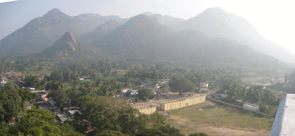
Padavedu - Land of Thousand Temples: History of Sambuvaraya and Their Capital
 |
| Vijayanagar style Venugopala and Rukmani statues amidst fields PC The Hindu |
 |
| Renugambal Temple PC Flickr Raju |
 |
| Entry to Padavedu from Santhavasal PC Flickr Raju |
Sambuvaraya dynasty, who ruled in the 12th and 13th Centuries, had Munnur (முன்னூர்), Virinjipuram (விரிஞ்சிபுரம்) and Kanchipuram (காஞ்சிபுரம்) as their capitals. After becoming independent from Pandyas, Sambuvaraya chose Padaiveedu as their capital for its strategic defensive location i.e., the land bastioned by tall hills and dense forests. The formation of Malayalam forests (மலையாளக்காடு), Shenbaga grove (செண்பகத்தோப்பு) and Athtimalai (அத்திமலை) on the north-west, Kalimathu hillock (களிமத்துக் குன்று) on the south-west and Santhavasal reserve forests (சாந்தவாசல் காப்புக்காடு) on the south provided adequate defensive measures. Santhavasal was the entry point to the capital.
The scenic Javadu hill is surrounded by seventeen villages and lush green paddy fields and coconut groves. It is believed that the region was known as the 'land of thousand temples' since it was the home to 1008 Shiva temples and 108 Vishnu temples. Now it is reduced to ten ancient (12th century) temples excluding the most popular Renugambal temple (ரேணுகாம்பாள் கோவில்).
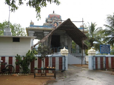
Renugambal Temple (Renuka Paramesvari Temple (ரேணுகா பரமேஸ்வரி கோவில்) also known as Yellamma Temple (எல்லம்மா கோவில்), Padavedu was built by Sambuvaraya. It is one of the most important ‘Sakthi Sthalas’ in Thondainadu. Goddess Renugambal is self-manifested here and a Banalingam is present. Adi Sankarar has consecrated the Nanakarshna Chakra This south facing ancient temple exists even today. Three inscriptions have been copied from this temple.
Also there is a newly constructed temple. The outer walls of the granite structured vimana is decorated with bas relief images depicting puranic scenes. The goddess resides in the east facing sanctum. There are ardhamandapam, mahamandapam and there are shrines minor deities.
The Sri Venugopalaswami Kainkaryam Trust,(வேணுகோபாலஸ்வாமி கைங்கர்யம் டிரஸ்ட்), a part of TVS group, takes over the village about 20 years back and maintains the age old temples flawlessly. Number of temples were identified, unearthed and renovated by the trust during 1990s. Very few of these temples retain their original facade and the temples include:
 |
| PC Tamilnadu Tourism |
- Lord Venugopala Swamy temple (வேணுகோலஸ்வாமி கோவில்) is located on the top of Rajagambhiramalai (hill top) popularly known as Kottaimalai (Athimalai). The temple opens only on Saturdays from 9 am to 4 pm. A ghat road runs through the dense forest and leads to the hill top. People used to travel by using the off-road wheeled tractor from the foothill to the hill top over this bumpy route.
- Yoga Ramachandraswamy Temple (யோக இராமச்சந்திரஸ்வாமி கோவில்), Padavedu, constructed before 12th Century AD, is located 1 km west of Renugambal Temple. Lord Rama is uncommonly seated in Artha Padmasana posture showing “Chin Mudra” and his hand is not holding his bow (Kothandam). He is accompanied by his consort Seetha and brother Lakshmana by his side. Hanuman appears seated before Rama and engaged in reading Palm leaf manuscripts. Lord Rama is also appear seated and showing 'Chin Mudra' at Nedungunam and Ragunatha Samudram temples, both are located in Tiruvannamalai dist..
- Lakshmi Narasimhar Temple (லட்சுமி நரசிம்மர் கோவில்), Ramanathapuram, Padavedu located on a hill top. Kamandala river (கமண்டல நதி) flows by the side of this temple. It was built by Mankonda Sambuvarayar (மண்கொண்ட சம்புவராயர்). Temple ruined due to natural disaster and now renovated by TVS Group trust. The bridge, built at a later date by the trust, connects the temple and the village. Also there is a cement path leading to the hill top. Goddess Lakshmi is seated on the right side of Narasimhar.
- Velmurugan temple (வேல்முருகன் கோவில்) is located on top of Natchathra Kundru (நட்சத்திரக் குன்று) (Star Hill). A Vel (வேல்) (lance of Lord Muruga) is consecrated by the Bhogar (போகர் சித்தர்), one of the 18 Siddhars and Poojas are performed daily.
- Chinna Kottai Varadhar Temple, Padavedu is located 2 km north west of Renugambal temple.
- Kailasa Vinayagar Temple (கைலாச விநாயகர் கோவில்), Padavedu is located on the northern side of Renugambal temple with a distance of 2 km. The prime deity Lord Vinayagar is huge and has a height of five and a half feet and looks very majestic. The ancient temple built hundreds of years back was fully destroyed. The renovation work of this temple was carried out by TVS trust.
- Rishi Temple (ரிஷி கோவில்) or (Lord Budha Temple) is located near Renugambal Temple. Rishi idol was retrieved at this spot and consecrated in the newly built temple.
- Ammayappa Esvarar Temple, Padavedu, a 12th century temple, is considered as the most ancient temple and located one km west of Renugambal temple. It is the family deity of Sambuvarayas. The prime deity is Ammayappa Esvarar (Lord Shiva) and his consort is five feet tall goddess Aparnambigai. The temple totally buried due to sand storms and excavated. The procession deities hidden underground were also discovered and installed in Utsava Mandapam.
- Periya Kottai Varadhar Temple, Padavedu is located 2 km north west of Renugambal temple.
- Sadasivan Temple (சதாசிவன் கோவில்) is devoted to Lord Shiva and his consort and located in Vettagiripalayam, Padavedu.
- Kailasanathar Temple (கைலாசநாதர் கோவில்), Kailasaparai (கைலாசப் பாறை), Padavedu is totally in ruin and is located towards north on top of Kailasaparai hillock. There is no provision for flight of steps to climb. The prime deity is Lord Kailasanathar (Lord Shiva) who appears with his consort Parvathi in a ruined sanctum (no ceiling). The four hands of the Lords are lost. Also a Shivalingam is found. Vimanam is in Gajaprishta style. No pooja rituals are performed.
- Subramanya Swamy Temple is located on a hill top, on the southern side of Arulmigu Renugambal Temple. The flight of three hundred well laid stone steps leads to this hill temple.
- The village once had eight Anjaneya statues placed in eight cardinal directions to guard the place. Now only five of them remain. Installation of guardian deities is characteristic of the Vijayanagar empire. Veera Anjaneyar Temple is located on the way leading to Ramar temple from Renugambal temple and also located close to the Draupadhi Mandapam. Eight feet tall sthanaka Veera Anjaneyar appeared majestically in open air. Only 3 years back the Lord was consecrated to the present shrine.
 |
| Yoga Ramachandraswamy Temple, Padavedu PC Tamilnadu Tourism |
 |
| Venugopala Swamy temple, Rajagambhiramalai (Kottaimalai) PC Tamilnadu Tourism |
 |
| Kailasanathar Temple, Kailasaparai, Padavedu. PC Tamilnadu Tourism |
 |
| Kailasa Vinayagar Temple, Padavedu PC Tamilnadu Tourism |
Sambuvaraya Dynasty
Sambuvaraya kings (சம்புவராய மன்னர்கள்) hailed from Velir clans (வேளிர் குலம்). The Velirs were minor feudatory chieftains in the ancient Tamilakam. They were vassals as well as rivals of Chola, Chera and Pandyas and maintained marital relationships with them and enjoyed coronation rights. During 12th and 13th Centuries, the Sambuvarayar chieftains ruled Tondaimandalam region. Ethirili Chola Sambuvaraya (எதிரிலி சோழ சம்புவராயர்) , who ruled the northern part of Tondaimandalam, was.a vassal under Rajadhiraja Chola II (இரண்டாம் இராஜதிராஜ சோழர்) and Kulotunga Chola III (மூன்றாம் குலோத்துங்க சோழன்) and this chieftain hailed from the family of Sengeni. Omaindha Munnutruvan Palliyana Karanamanikyam (செங்கேணி ஓமைந்த முந்நூற்றுவன் பள்ளியன் கரணமாணிக்யம்) was his ancestor. His father was Sengeni Ammaiyappan Kannudaiya Peruman Vikrama Chola Sambuvarayar (செங்கேணி அம்மையப்ப கண்ணுடைய பெருமான் விக்கிரம சோழ சம்புவராயர்). He was decorated with the titles such as Virasani (விராசனி), Viruchola (வீறுசோழ) and Pallavandan (பல்லவந்தன்).
Sambuvarayas stationed their troops to maintain and guard at Padavedu fort and hence the name 'Padaiveedu' (garrison or fortified military post) and inscriptions mention this as Marudaraisan Padaiveedu (மருதரைசன் படைவீடு) (Cantonment of the king Madurai). At the time Sambuvarayas were under the patronage of Pandyas. During the reign of Jatavarma Sundara Pandya I ((Tamil: முதலாம் சடையவர்மன் சுந்தரபாண்டியன்) (1250 - 1268 A.D). Sundara Pandya Sambuvaraya was ruling the land as a feudatory from Kanchipuram (ref. inscription at Kalavai S.I.I. vol XII no. 446).
Sambuvarayas stationed their troops to maintain and guard at Padavedu fort and hence the name 'Padaiveedu' (garrison or fortified military post) and inscriptions mention this as Marudaraisan Padaiveedu (மருதரைசன் படைவீடு) (Cantonment of the king Madurai). At the time Sambuvarayas were under the patronage of Pandyas. During the reign of Jatavarma Sundara Pandya I ((Tamil: முதலாம் சடையவர்மன் சுந்தரபாண்டியன்) (1250 - 1268 A.D). Sundara Pandya Sambuvaraya was ruling the land as a feudatory from Kanchipuram (ref. inscription at Kalavai S.I.I. vol XII no. 446).
Vira Pandya Sambuvaraya, the son of Sundara Pandya Sambuvaraya was also a loyal feudatory of Pandya. Sambuvaraya became independent after the Delhi Sultans uprooted Pandyas. They made Padaiveedu as their capital and ruled till the rise of Vijayanagar kingdom in Karnataka.
Inscription A.R.E 18 of 1889 mention this region as the 'Rajagambhira Rajyam' (இராஜகம்பீர இராஜ்யம்) named after Rajagambhira Sambuvraya (இராஜகம்பீர சம்புவராயர்) (1236 - 1268 A.D.) as well as 'Padavittu Rajyam' (படைவீட்டு இராஜ்யம்). The bordering hillock around the Padaiveedu is mentioned in an inscription no. A.R.E no. 220 of 1919 as 'Rajagambhiran Malai' (இராஜகம்பீரன் மலை) which also named after Rajagambhira Sambuvrayar. The capital of this illustrious kingdom was mentioned as 'Marudaraisan Padaiveedu,' in inscription S.I.I vol. 1, no. 81 Sambuvaraya rulers built their palace structures and protected them with 'Rajagambhiram Fort' and a wide moat.
Ekambaranatha Sambuvaraya (ஏகாம்பரநாத சம்புவராயர்), a Sambuvaraya feudatory under Maravarman Kulasekara Pandya (மாறவர்மன் குலசேகர பாண்டியன்), ruled parts of Tondaimandalam independently from 1306 AD. An inscription from Tiruvannamalai district speaks about this subject. Ekambaranatha Sambuvaraya witnessed the invasion of Malik Kafur (மாலிக் காபூர்) in 1311 A.D and Kushru khan (குஸ்ரு கான்) in 1319 A.D. In 1322 Ekambaranatha Venru Mankonda Sambuvaraya (ஏகாம்பரநாத வென்று மண்கொண்ட சம்புவராயர்) (1322 - 1337 A.D.), the son and successor of Ekambaranatha Sambuvaraya became the ruler of a major portion of Tondaimandalam. The village donated to great vedic scholars by this Sambuvaraya king after he won in the war, hence the village is called Mankonda Kolathur (now termed as Mandakolathur) and the king was known in the name of Vendru Mankonda Sambuvaraya. Also during his reign in 1324 A.D. Mohamed Bin Tugklaq's army invaded the land and destroyed many Hindu shrines. Tiruvamathore (திருவாமத்தூர்) (Villupuram District) inscription informs about the renovation of the destroyed temples by the Sambuvarayar king.
Venru Mankonda Sambuvarayar was succeeded by Rajanarayana Sambuvaraya I (முதலாம் இராஜநாராயண சம்புவராயர்) (1337 - 1373 A.D.). In the year 1363 Vira-Kampana-Udaiyar (வீர கம்பண உடையார்), also known as Kumara Kampanna II (இரண்டாம் குமார கம்பண்ணா) , second son of Bukka Raya I (முதலாம் புக்க இராயர்) and the prince of Vijayanagar who ruled from Kanchipuram, attacked Rajanarayana Sambuvarayar I and captured him as the prisoner.
Rajagambhiram fort
During 11th regnal year (1247 A.D.) Rajagambhira Sambuvarayar (1236 - 1268 A.D.) built Rajagambhiram fort on top of the hill, 'Rajagambhiran Malai.' An inscription on top of the hill informs about this. The fort straddled the entire hill. They have used granite boulders and 10 inches by 7 inches bricks, sand and lime mortar to construct the fort wall. The perimeter of the fort extends up to two kilometers. In fact this fort was hard to conquer for it can be accessed only through four gates and cannot be accessed easily through other means. It was constructed for surveillance and control the movements Delhi Sultanates and Vijayanagar rulers. The fort had provision for shelters for soldiers posted on surveillance duties. The rock surface do show pits for erecting poles for tents and they could have erected nine tents on top of the hill. They have also made provision for storing water in tanks as well as in natural ponds. They have also made one foot diameter by one foot deep pits for provision and use of mortar weapon. The fort also exhibits evidences for the existence of temples dedicated to Lord Shiva and Lord Vinayaga.
The northern gate is presently called as Santhavasal (Santha gate). A hero stone is discovered near Santhavasal. The eastern gate is in ruined state and the western gate, named after Puvandai alias Cholakon, one of the Mudalis in the military service of Ethirili Chola Sambhuvaraya, is fully destroyed. There was a moat encircling the fort.
Madura Vijaya ('The Conquest of Madurai')
 |
| PC Wiki media |
“King Kampana, then converted the Tamil king’s town into an encampment for his own force, and from there began to lay siege to the hill fortress named Rajagambhira (Rajagambhiramalai) in which the enemy had sought asylum.
The sound of his war drums raised echoes from every cave of the hill and it looked as if the hill itself had begun to yell out in freight.
With the flags flying in the direction of high winds, the hill (fort) gave the impression that it was greeting king (Kampana) and welcome him with its arms (the flags) to come up to its top.
Again, fierce fighting commenced between the two sides, and the weapons falling down and shooting up, lit up both earth and sky by their resplendence.
Heads severed by arrows resembled palmyra fruits as they fell down from the ramparts and caused an illusion that the balls belong to the deity of war (for playing (with).
Like messengers (tax-collectors) sent by the strong hold themselves claiming the tolls for the entry (of the Karnataka troops) the stones let down from the catapults fell just in front of the king.
The hill, with the houses lit up by fire from the missiles of bow-men looked like holding the lamp in readiness harati for the happy ceremony to mark the auspicious victory of the king.
With all means (and chances of escape) coming completely blocked, the strong hold was subjected to such great distress that embryos of women, big with children slipped out at the very sight of the fierce jumping in, and people immersed in the river of blood of the slain prayed for their life.
Sambuvaraya, the monarch withdrawn sword, came out of his palace in great anger, even as a snake with its lolling tongue might come out of a mole-hill.
Though many a soldier of valour eagerly came forward to fight saying “let me do it,” King Kampana preferred to face the Sambuvaraya himself.
With forepart of their body bent and eyes fixed, the two kings sword in hand, stood still for a moment like a picture on a piece of painting.
The gods were thankful for the total absence of winking their eyes, as they looking on with fixed gaze, the flight (of the two horses) their bodies divided at the waist.
Kampana’s sword, reflecting as it the image of the Sambuvaraya monarch, looked like a pregnant daughter about to give birth to a husband for the celestial nymphs.
Then escaping deftly a sword thrust, King Kampana despatched the Sambuvaraya (monarch) as a guest to Indra’s city.
Having thus reduced (killed) Sambuvaraya in the field of battle, King Kampana received the decree of his father that he should rule (the territory he conquered).”
From the above poem it is presumed that there was a palace and huge fort wall, both of which were guarded by large number of soldiers, wielded by bow and arrows and lances. The citadel located in the Rajagambhiram hill was sieged and the ruler was stabbed to death by Vira Kampana in 1361 A.D. After this Vira Kampana marched to Kanchipuram and conquered.
In 1311 A.D. Malik Kafur attacked Madurai and plundered all temples. Ghiyasuddin Tughlak made second invasion to Madurai and established Madurai Sultanate. Madurai suffered a lot during 1335 - 1371 A.D. The temple remain closed for nearly 40 years. Madura Vijaya details the sufferings of Hindus in the hands of Madurai Sultans. Hoysala ruler Veera Vallala encountered with Sultan and was killed in the battle. The huge army of Vira Kampana stormed Madurai Sultanate and Vira Kampana killed the Madurai Sultan Qurbat Hasan Kangu in the battle. Later the entire Madurai country and Chola country were included with Vijayanagar kingdom. Two divisions namely Rajagambhira Rajyam and Tiruvathigai Rajyam were formed.
Padavedu Excavations
The Tamil Nadu State Department of Archeology conducted excavations in Padavedu in the year 1992-93 at two sites namely Vetagiripalayam (வேட்டைகிரிபாளையம்) and Kottaikaraimedu (கோட்டைக்கரைமேடு). The existence of the palace and the fort wall was ascertained by the Department of Archeology during excavations. A mound, just on the west of Padavedu village, was popularly known as 'Kottaimedu' (கோட்டைமேடு). Kottaimedu is located one km away from Yoga Ramachandraswamy temple. Presently the Kottaimedu lands have been converted into cultivable patta land and paddy, sugarcane and plantain crops are cultivated. Two Vishnu idols namely Chinna Kottai Varadar (சின்னக்கோட்டை வரதர்) (Varadar of Small Fort) and Periya Kottai Varadar (பெரியகோட்டை வரதர்) (Varadar of big fort) were found near the Kottaimedu mound. Sculptures of Kottai Talayari (கோட்டைத் தலையாரி), Viraanjaneya (வீரஞ்சநேயர்), Mahaganapathy (மகாகணபதி) and two Tirthankaras (தீர்த்தங்கரர்கள்) were discovered in 'Kottaimedu' itself. The sculptures found in these locations clearly lead the archaeologists to conclude that there was a fort at the site. Further to this, occurrence of bricks in huge quantities as well as sizable number of ring wells also suggest the presence of fort at the site. The traces of fort gates on the Kottaimalai (Athimalai) (அத்திமலை) or Rajagambhiram hill and the existence of Venugopala temple and brick graneries assignable to Nayak period suggest the scholars to conclude about the fort.
The team laid 14 trenches. At Vetagiripalayam two trenches were laid to fully expose the age old brick structure appeared out due to rain. At the first trench they discovered terracotta tube with a tiny hole (bellows tube) (துருத்திக் குழாய்). It could have been the mechanical device, made in clay, used as blow pipe for glass making. The glass slag piece retrieved from this trench supports this view. The second trench dug to the west of the first trench exposed the relics of the brick wall fully.
At Kottaikaraimedu twelve trenches were laid. This site is marked with the occurrence of brick structure, with the channels used for bringing drinking water and draining out sewage water and ring wells. They have used granite boulders to construct both the sides of the wall and filled the middle portion with the mixture of clay and crushed brick stones and they could ascertain the width as 1 m 15 cm and the height of the brick wall structure could not be ascertained. The site is marked by the presence of smoking pipes, Sultan coins and a number of decorated red ware shreds and bangle pieces were collected from this site.
On the basis of cultural sequences of these sites, the archaeologists have classified as period one and period two. The date assignable to period one could be between 13th and 14th Century A.D. The date assignable to period two could be between 14th and 16th century A.D.
InscriptionThe team laid 14 trenches. At Vetagiripalayam two trenches were laid to fully expose the age old brick structure appeared out due to rain. At the first trench they discovered terracotta tube with a tiny hole (bellows tube) (துருத்திக் குழாய்). It could have been the mechanical device, made in clay, used as blow pipe for glass making. The glass slag piece retrieved from this trench supports this view. The second trench dug to the west of the first trench exposed the relics of the brick wall fully.
At Kottaikaraimedu twelve trenches were laid. This site is marked with the occurrence of brick structure, with the channels used for bringing drinking water and draining out sewage water and ring wells. They have used granite boulders to construct both the sides of the wall and filled the middle portion with the mixture of clay and crushed brick stones and they could ascertain the width as 1 m 15 cm and the height of the brick wall structure could not be ascertained. The site is marked by the presence of smoking pipes, Sultan coins and a number of decorated red ware shreds and bangle pieces were collected from this site.
On the basis of cultural sequences of these sites, the archaeologists have classified as period one and period two. The date assignable to period one could be between 13th and 14th Century A.D. The date assignable to period two could be between 14th and 16th century A.D.
 |
| Structural Remains and Flooring PC Dept. of Archeology |
 |
| Closed Channel PC Dept. of Archeology |
S.I.I Vol. V, No.78. on the east and north bases of the Ammaiappa esvara Temple, Padavedu
Inscription S.I.I. vol V, no. 78 dated - on the nakshatra Revati and Monday, the seventh lunar day of the former half of the month of Karkataka, in the year, which was current after the expiration of the Saka year 1180 (1258 A.D.), and records a grant, which Rajagambhira-Sambuvarayan made to the temple of Ammaiappa esvara. The name of the object of the grant must be contained in the final portion of the first line, which is buried underground. The donor is evidently identical with that Rajagambhira-Sambuvarayan, who is mentioned in a Tirumalai inscription (No.74), which seems to be dated in Saka 1157-58. It may be further conjectured, that the Ammaiappesvara Temple at Padavedu had received its name from Ammaiappan or Ammaiyappan, one of the birudas of another Sambuvarayan, who was a contemporary and probably a relation of Rajagambhira-Sambuvarayan.
S.I.I Vol. V, No.79. on the south-east of the Ammaiappa esvara Temple, Padavedu
This inscription is dated during the reign of Vira-Devaraya-maharayar (of Vijayanagara) and On the tenth day of the month of Masi of the Pramadicha (i.e., Saka 1356) (1434 A.D.). It records a grant to the lord Ammaiappa-nayanar of the Ammaiappa eswara Temple. The name of the donor is obliterated (Madhayavanar?). This meritorious gift shall last as long as the moon and the sun. He who shall injure this meritorious gift, [shall incur the sin of one has killed] a black cow on the bank of the Ganga.
S.I.I Vol. V, No.80. on the south wall of the Ammaiappa esvara Temple, Padavedu
This inscription is dated during the reign of Vira-Devaraya-maharayar (of Vijayanagara) and on the 2nd day of the month of Adi on the Ananda year,. (i.e.,Saka 1357). It records the gift of a village to the lord Ammaiappa-nayanar of the Ammaiappa esvara Temple. The middle portion is defaced by three cracks. The donor is Ulagalantha Suryadeva of Kalavai.
S.I.I Vol. V, No.81. on the east wall of the Somanatha eswara Temple, Padavedu
This inscription is dated on the day of (the nakshatra) Uttiradam, which corresponds to the Yoga Ayushmat and to Saturday, the thirteenth lunar day of the former half of the month of Simha of the Sukla year, which was current after the Saka year 1371 (had passed) (1449 A.D.), and during the reign of Virapratapa Praudha-Immadi-Devaraya-maharayar. This is the latest hitherto-known date of Devaraja II. In the preserved portion, mention is made of the kingdom of Padaividu (Padaivitttu rajyam),which belonged to Tondai-mandalam, of the right and left had castes and of the Somanatha esvara Temple at Padaividu.
Nearest Bus stand: Padavedu is located around 30.9 km away from Vellore and around 56.7 kilometer away from its district head quarter Tiruvannamalai. Santhavasal (Padavedu) is well connected with major nearby towns like Arani, Arcot, Vellore and Thiruvannamalai and Polur. Frequent buses ply to Santhavasal from Kancheepuram, Vellore, Polur, Arcot and Arani.
Nearest Railway station: The nearest railway station to Padavedu is Aliyabad which is located in and around 11.5 km distance. Both Arni Road railway station and Vellore Cantt. railway station are 28.8 km away from Padavedu..
Nearest Airport: Chennai airport is the nearest airport located at a distance of 139.7 km. Bengaluru airport is also a nearer airport located at a distance of 211.8 km.
Nearest Airport: Chennai airport is the nearest airport located at a distance of 139.7 km. Bengaluru airport is also a nearer airport located at a distance of 211.8 km.
- Discussion why pandyas lost to kafur. in Ponniyin Selvan Varalaatru Peravai (http://ponniyinselvan.in/forum/discussion/47339/why-pandyas-lost-to-kafur/p1)
- Land of a thousand temples. Anusha Parthasarathy. The Hindu June 27, 2013
- Maduravijayam. Gangadevi. Tr. by Tiruvenkatachari. Canto IV, Slokas 64 - 83.
- Madura Vijayam Wikipedia
- Padavedu Excavation. Natana Kasinathan. Asst. by Abdulmajeed, Sampath KS, Selvaraj S, and Kalaivanan M, State Department of Archaeology, Chennai. 1993 (http://210.212.62.26/pdf_files/books/PADAVEDU%20EXCAVATION%20part%20002.pdf) and (http://210.212.62.26/pdf_files/books/PADAVEDU%20EXCAVATION%20part%20003.pdf)
- Padavedu, Thiruvannamalai. Tamilnadu Tourism. March 24, 2016. (http://tamilnadu-favtourism.blogspot.in/2016/03/padavedu-thiruvannamalai.html)
- Sambuvaraya Wikipedia
- Sambuvarayar period stone inscription found The Hindu. April 07, 2002
- Visit to Padavedu Kottaimalai Sri Venugopala Swamy Temple. Raju's Temple Visits. June 13, 2008 (https://shanthiraju.wordpress.com/2008/06/13/kottamalai/)
- Visit to Padavedu Temples. Raju's Temple Visits. May 26, 2008. (https://shanthiraju.wordpress.com/2008/05/26/padavedu/)
- What is India. South Indian Inscriptions. Part B: Tamil and Grantha Inscriptions. V Inscriptions at Padavedu (http://www.whatisindia.com/inscriptions/south_indian_inscriptions/volume_1/padavedu.html)
YouTube
Mann Pesum Sarithiram epi 290
Kottaimalai Trip
Vel Temple at Padavedu
Sunday, October 16, 2016
Thirunanthikarai Cave Temple
Thirunandhikarai, (Tamil: திருநந்திக்கரை, Malayalam: തിരുനന്തികര ) also known as Thirunandhikara, rock cut cave is located in Thirunandhikarai village, Kalkulam (கல்குளம்) taluk, Kanyakumari (கன்னியாகுமரி மாவட்டம்) district, Tamil Nadu state, India PIN 629161. This village is located in the Kulasekaram (குலசேகரம்) - Pechipparai (பேச்சிப்பாறை) road and forms part of Thirparappu special village panchayat and Kulasekharam post office limit. The Latitude and Longitude coordinates of Kulasekaram are N 8° 22' 5.1445" (8.368096°) and E 77° 18' 3.0622" (77.300851°) respectively. The elevation / altitude of Kulasekaram is 280 meters (920 feet) above sea level.
Kanyakumari, mostly preferred by travelers since it has many tourist attractions. There are around 25 tourist places in Kanyakumari district for the travelers to explore and they include Vivekananda Rock Memorial, Muttom Beach, Keeriparai Reserve Forest, and Ullakaarvi, all vie for attention. Other charmers include Government Museum, Thanumalayan Temple, and Kanyakumari Wildlife Sanctuary. Thirparappu Falls (திற்பரப்பு அருவி) is the famous falls in the Kothai River (கோதை ஆறு). Kulasekaram has many rubber plantations. and has a respectable transport network Thirunandhikarai village and cave are located 3 km from Kulasekaram, 11 km from Pechiparai Dam (பேச்சிப்பாறை அணை), 5 km from Thriparappu Waterfalls, 38 km from Nagerkoil and 50 km from Kanyakumari. The nearest airport is at Thiruvananthapuram. The best season to visit places in Kanyakumari is between February - December. ISRO chairman Mr. Madhavan Nair was born and brought up in Thirunandhikarai.
Kanyakumari, mostly preferred by travelers since it has many tourist attractions. There are around 25 tourist places in Kanyakumari district for the travelers to explore and they include Vivekananda Rock Memorial, Muttom Beach, Keeriparai Reserve Forest, and Ullakaarvi, all vie for attention. Other charmers include Government Museum, Thanumalayan Temple, and Kanyakumari Wildlife Sanctuary. Thirparappu Falls (திற்பரப்பு அருவி) is the famous falls in the Kothai River (கோதை ஆறு). Kulasekaram has many rubber plantations. and has a respectable transport network Thirunandhikarai village and cave are located 3 km from Kulasekaram, 11 km from Pechiparai Dam (பேச்சிப்பாறை அணை), 5 km from Thriparappu Waterfalls, 38 km from Nagerkoil and 50 km from Kanyakumari. The nearest airport is at Thiruvananthapuram. The best season to visit places in Kanyakumari is between February - December. ISRO chairman Mr. Madhavan Nair was born and brought up in Thirunandhikarai.
There are two important Shiva temples in Thirunandhikarai: Thirunanthikara Nanthishwaran Temple and Thirunandhikara Cave Temple. Nanthishwaran Temple is situated on the river banks of Nandhiaaru. Thirunandhikarai is the fourth shivalayam among the 12 saivite shrines in Kanyakumari district (1 Tirumalai, 2 Thikkurichi, 3 Thirparappu, 4 Thirunandhikkarai, 5 Ponmanai, 6 Pannippagam, 7 Kallkkulam, 8 Melancode, 9 Thiruvidaicode, 10 Thiruvithamkode, 11 Thiruppanticode and 12 Thirunattalam). There will be a marathon run by saivite devotees from shrine Thirumalai, the first shivalayam, to the twelfth, Thirunattalam on the day of Shivratri. The traditional Shiva temple also houses shrines for Lord Shiva and Lord Vishnu.
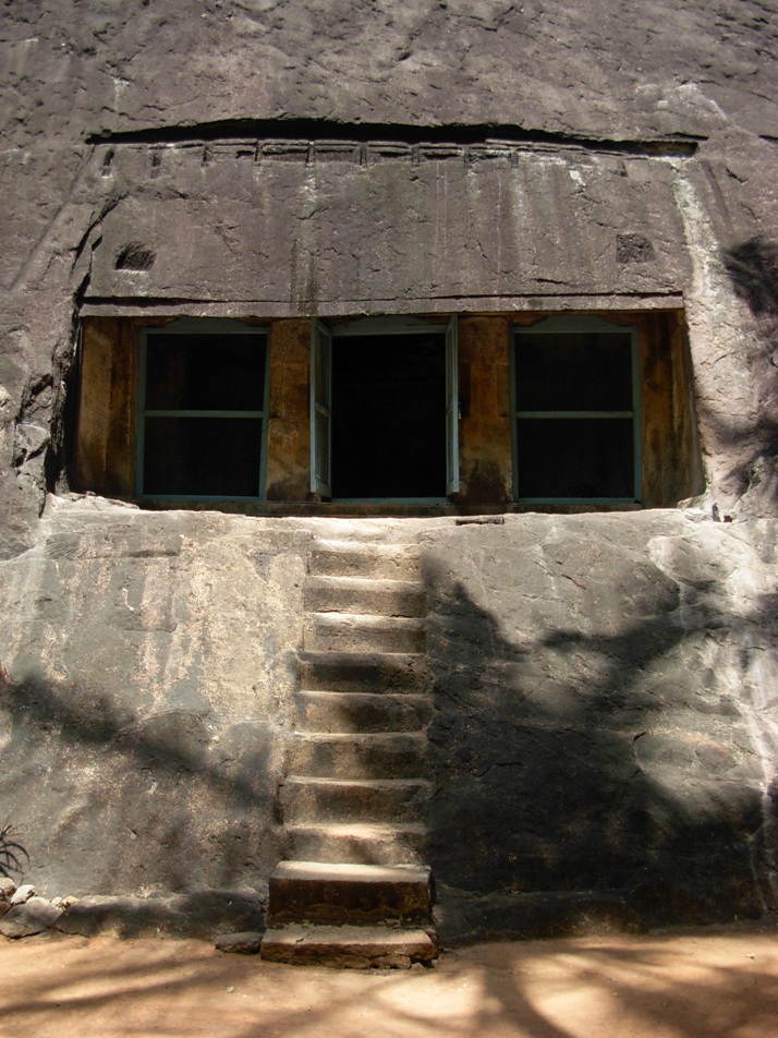
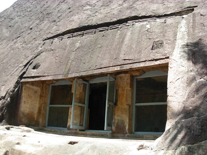
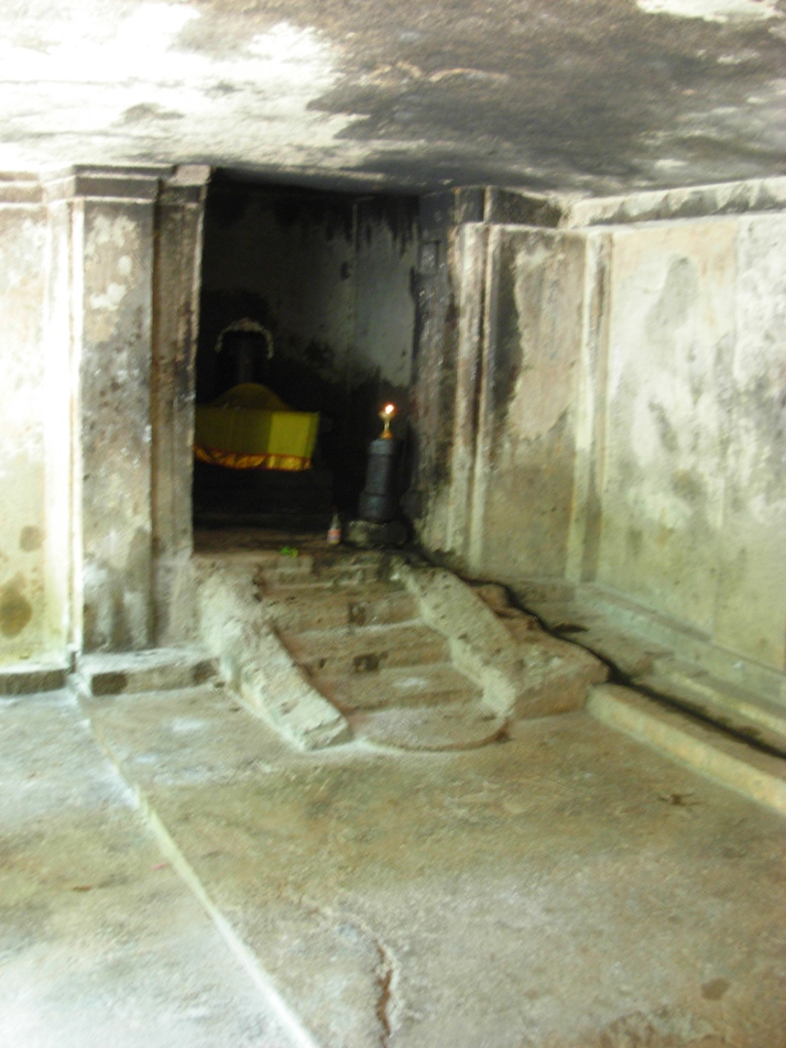
The south facing Thirunandhikkarai rock cut cave temple is excavated on the southern slope of the hillock and therefore the cave lies in an east-west orientation. The cave floor is formed 4 m above the ground level. A flight of ten steps (including the two steps provided later by Archaeological Survey of India (ASI), leads to the cave. Eight steps sculpted on the (mother) rock slope. The facade is 4.97 m in the north-south and 0.51 cm in the east-west directions. The evenly leveled rock ground is 5.68 m in the east-west and 64 cm in the south-north directions. The finely leveled rock floor is formed 4 cm above the rock ground and measures about 52 cm in the south-north and 5.40 m in the east-west directions. The upana is sculpted 5 cm above the rock floor and runs from east to west.
The facade is 4.97 m in the north-south and 0.51 cm in the east-west directions. It consists of two massive pillars in the middle and two pilasters on the corners. The pillars and the pilasters are square-kattu-square in shape. The plain angular potikas (corbels) support the slender uttira (beam). and there is no vajana above uttira. The rough rock brow forms the kapota (not designed well). The canopy of the kapota is flat. and do not incline downwards. Above the brow there are two rectangular sockets. There are also two sockets on the rock floor. These four sockets suggest the chances of forming temporary shed (பந்தல்). One meter above the kapota, bhumidesa is indicated with grooves and carvings.
The mother rock excavated well from top to down to match slopes of the hillock. The western wall is 1.97 m in height and 1.04 m in width and the eastern wall is 1.89 m in height and 1.19 m in width. There are two 1.54 m tall (shallow) niches on both the walls and Vettezhuthu inscriptions.(வட்டெழுத்து கல்வெட்டுக்கள்) are inscribed. The Vattezhuthu inscription on the 82 cm wide eastern wall is damaged and the other inscription on the western wall is intact. The upper square, kattu and part of lower square of the western facade pillar bear another Vettezhuthu inscription.
The facade leads to the rectangular mukha-mandapam which is 0.86 m in the north-south and 3.28 m in the east-west directions and 2.23 m in height. The inner-mandapam floor is raised to 0.6 cm in height. The mukha-mandapam floor is evenly sculpted. The plain eastern and western walls of mukha-mandapam show prastara components i.e., uttiram and vajanam between wall and the roof. The vajana is running through out the mandapam. The inner-mandapam on the rear is 5.40 m in east-west and 2.42 m in north-south directions and 2.18 m in height. Two square pilasters on either side of the cave walls of the inner-mandapam are supporting the uttira. The walls are plain. The roof of the mandapa is well formed.
The square sanctum is 2.16 m in all the four sides and 2.17 m height,. The walls and roof are plain. The Shiva Lingam is instituted in a socket pit which is 70 cm in east-west and 1 m in north-south directions. The square avudai is 82 cm in north-west and 78 cm in east-west directions and 0.53 cm in height. The external faces of avudai is embellished with padhabandha adishtana with components such as jagadhi (ஜகதி), octogonal kumudam (குமுதம்), khantam with pada flanked by kampa and without patiikai. The rudra bana is 44 cm in height. A small pit is shown towards north to receive the anointed water. A water chute is seen running up to the north wall and east wall of the sanctum and continued in the east wall of the mukha-mandapam.
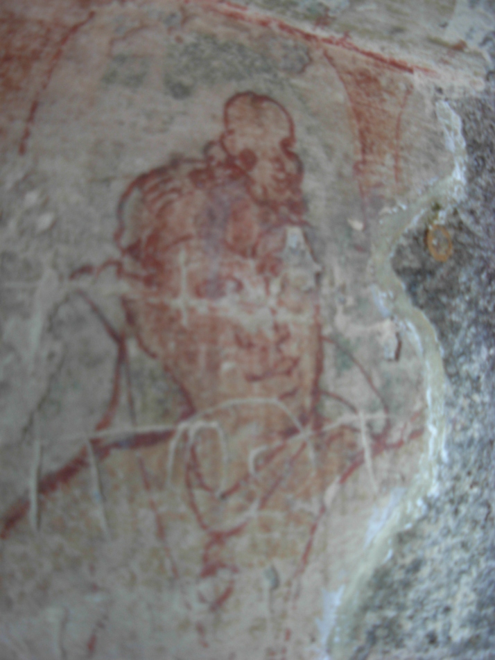
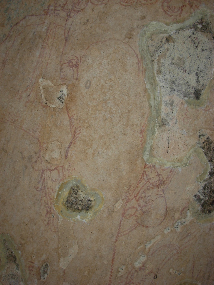
The northern wall of the inner-mandapam is washed with stucco coatings (sudhai) and painted with mural paintings. The mural paintings are considered as important since paintings belongs to earlier phase of Kerala mural art. The line paintings include the human figure with folded right hand on the chest and wears necklace with dollar. The right leg is folded and rested on the seat. The left leg could not be viewed.
The Ganapathy image is sculpted on the western wall of the mukha mandapam. The Lord wears Karandamakutam with head band, yagnopavitha, armlets and bracelets. The right rear-hand holds broken tusk, right fore-hand holds an unknown object, the rear left-hand holds sugar cane leaves and the fore-hand is damaged. The left tusk is visible and the right one could not be seen. The Vidyadharar is seen above right hand corner of Ganapathi. The flying figure holds a flower.
History:
Ay dynasty ruled the land between Nagercoil and Thiruvalla and Vizhinjam, The Ay Kingdom located to the south of Chera kingdom "functioned for long as an effective buffer state between the declining Chera kingdom and an emerging Pandya Kingdom." Ay dynasty was later known as Venad (வேள்நாடு / வேணாடு) dynasty. This land was also the scene of many battles. In 788 A.D, Vikramaditya Varaguna (885–925), an illustrious Ay ruler ruled Venad.
Jatilavarman Parantaka (Maranjadayan) the Pandya king waged a war over Ay kingdom and encircled Vizhinjam port. The Pandya conquered the Ays and made it a tributary state. Still the Ays refused to submit and fought against Pandyas for almost a century. Despite frequent defeats Cheras continued to exist as a fighting force. During ninth century Cheras rose again as a notable power. This region came under Cheras during the reign of Bhaskara Ravi Varman Tiruvadi (978 - 1036 A.D.). Rajaraja Chola I waged a war against the Venad ruler and captured the southern region and named it as Rajaraja Tennadu. Muttom is the fishing village in Kalkulam taluk. Rajaraj Chola I named it as Mummudi Chola Nallur.
The department of archaeology was started under the initiative of Professor Sundaram Pillai and the then Maharajah of Travancore, Moolam Thirunal Rama Varma sanctioned the monthly grant of Rs. 50.00 for its functioning. The renowned epigraphist T. A. Gopinatha Rao was employed as first Superintendent in the year 1908. T.A. Gopinatha Rao edited and published The Travancore Archaeological Series (T.A.S.) from 1910. Thus T.A.S. inaugurated the systematic survey and collection of inscriptions in the erstwhile Travancore state. The scholar also visited Thirunandhikarai and Chitharal caves in 1920-21 and copied and recorded the inscriptions from the caves. .According to T.A.Gopinatha Rao, the cave temple was built during the reign of the king Vikramaditya Varaguna. Chitharal was erected at Tirucharanam at the behest of a Jain priestess called Muttavala Naranakuttiyar, who also presented the temple a metallic lamp stand and a golden flower. Rao also believed that Thirunandhikkarai rock cut cave was excavated by Vikramaditya Varaguna, the Ay ruler in 9th century A.D in simple Pandya style. The rock cut caves were the founding caves of Jainism. Thirunandhikarai cave also served as dwelling place to Jain ascetic Veeranandi, who came from Thirunarunkondai Melappalli and preached Jainism during 8th century. One more cave temple Kurathiarai was also excavated in the ninth century when this region was under the influence of Jainism. Thirunandhikarai rock cut cave is under the maintenance of the Archaeological Survey of India (ASI).
Inscriptions:
This cave has four Vattezhuthu (வட்டெழுத்து) inscriptions (Travancore Archaeological Series (T. A. S.) vol. I., p. 413.) inscribed one on each side of the entrance and others on each side of the pillars. One of which bears the name of the ruler and his regnal year. The inscription, dated in the 18th regnal year of Rajaraja Chola I (முதலாம் இராஜராஜ சோழன்) found on the western cave wall, registers the gift of Muttom (முட்டம்), the village (name changed as Mummudi-chola-nallur மும்முடிச்சோழநல்லூர்) in Valluva-nadu (வள்ளுவநாடு) under Rajaraja-thennadu (இராஜராஜ தென்னாடு). The gift was made for the celebration of a festival for Mahadeva of Tirunandikarai (திருநந்திக்கரை மகாதேவர்) and also for ablution of the deity in the river, on the Satabhisha, star (சதய நட்சத்திரம்) day in the Tamil month Aippasi, (ஐப்பசி) (October - November) in the year 1003 A.D, being the birthday of the king. Records a provision made by the king for supply of one nazhi (நாழி) measure ghee every day for lighting the perpetual lamp in the name of Rajaraja Chola I in the temple.
Inscription Travancore Archaeological Series (T. A. S.) Vol. III, pp. 200-203 inscribed on a pillar, whose date assignable to eight century A.D., records the gift of 'Ur' (ஊர்-a village). For this purpose one Dhaliyazhavan (தளியாழ்வான்), along with the 'elders' of Tirunandikarai (திருநந்திக்கரை பெருமக்கள்) assembled in Kurunthambakkam (குருந்தம்பாக்கம்). The assembly converted the Ur's name into Sri Nandimangalam and gifted to one Nambi Ganapathi (நம்பி கணபதி) for purposes of mid-night offerings (நள்ளிரவுத் திருவமுது) to the Lord of the temple. The four boundaries (எல்லைகள்) are cited for the village under gift and include a river (name not known) (ஒரு பெயரற்ற ஆறு), Nandhi river (நந்தியாறு), Mudukonur (முதுகோனூர்) and Pakkamangalam (பாக்கமங்கலம்). Gopinatha Rao, who copied and recorded the inscription, has pointed out the present existence of Mudukonur and Pakkamangalam near Nandhimangalam.
Inscription Travancore Archaeological Series (T. A. S.) Vol. III, pp. 203-206 comprising 40 lines was inscribed on another pillar. This inscription records the gift of land by Mangalacheri Narayanan Sivakaran to Tiruvallavazh Mahadevar of Tirunandikarai (திருநந்திக்கரையில் உறையும் திருவல்லவாழ் மகாதேவர்). The inscription lists out the land pieces. Resolved the wages to be issued from the land produce accrued from the above land: four measures (கலம் Kalam) to Santhipuram, five measures (கலம் Kalam) to Uvachar (category of temple staff), five measures (கலம் Kalam) to Udayar (category of temple staff) and cleaning staff as well as for puja rituals, The perpetual lamps were lit using 60 measures (uri - உரி) of ghee from the remaining land produce.
Road Transport : Thirunandhikarai and its nearest town Kulasekaram are well connected from Thirvananthapuram or Kovalam Beach or Kanyakumari. You can get busses from Nagercoil, Thuckalay, Marthandam, Kulasekaram. Kerala Tourism Development Corporation (KTDC) organizes local site seeing tours.
Nearest Railway Station is Marthandam. Nagerkoil railway station is 15 km away. Kanyakumari railway station is connects with major cities in India.
Nearest Airport is Trivandrum International Airport.
Reference
- A topographical list of the inscriptions of the Madras presidency (collected till 1915) with notes and references by Rangacharya, V. (Vijayaraghava); Archaeological Survey of India 1919
- Kerala State Archaeology Department (Wikipedia)
- On the southern tip of India, a village steeped in the past. The Hindu November 17, 2011
- Thirunandikkara Cave Temple in Thirparappu in Kanyakumari. Yatra to Temples.com (http://www.yatrastotemples.com/thirunandikkara-cave-temple-in-thirparappu-in-kanyakumari/)
- Thirunanthikarai (Wikipedia)
- Thirunanthikarai Cave Temple. C.P.R. Environmental Education Centre, Chennai. (http://www.cpreecenvis.nic.in/Database/ThirunanthikaraiCaveTemple_2939.aspx)
- Thirunanthikarai Cave Temple. Tourmet.com (http://tourmet.com/thirunandhikarai-cave-temple/)
- Thirunanthikarai inscription. Kerala Culture.org (http://www.keralaculture.org/thirunanthikara-inscriptions/366)
- திருநந்திக்கரைக் குடைவரை இரா.கலைக்கோவன், மு.நளினி வரலாறு.காம் இதழ் 63 (செப்டம்பர் 15 - அக்டோபர் 15, 2009)
Thursday, September 29, 2016
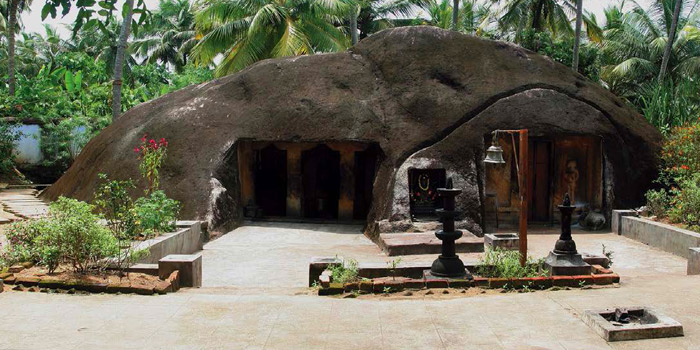
Madavoorpara Cave: Hindu Rock cut Temple near Thiruvananthapuram, Kerala


Madavoorpara rock-cut cave temple is situated in Madavoopara village, Kazhakuttam taluk, Thiruvananthapuram district, Kerala, India PIN 695587. It is forming part of Ayiroorppara Panchayat and located between Pothencode and Chempazhanthy.. The cave is located 15 km towards North from District head quarters Thiruvananthapuram. Madavoopara is geographically located at latitude 8 ° 35′ North and longitude 76 ° 59′ E' and the altitude / elevation is 64 m (210 ft). The rock cut cave temple was owned by the Chenkottukonam Ashram and from 1960 the premises is protected by the State Archaeological Department. It is one of the two rock cut caves in Thiruvananthapuram district.
Architecture
The rock cut cave excavated on the solid rock face on top of the hillock. To reach the cave, you have to climb more than 200 steps. The flight of thirty three steps, sculpted on the rock, leads one to the square-shaped cave temple. The rock cut cave is dedicated to Lord Shiva. The images of Lord Shiva and Lord Ganapathy sculpted on the right side of the wall. On the left side there is an image of the local chieftain.
History
Buddhism and Jainism spread in Kerala around 3rd century A.D. Jainism continued to have strong hold for about 700 years in south Kerala region. The earliest Buddhist rock-cut cave abodes were built for Buddhist missionaries (monks) by the kings and traders on the busy international trading routes. Vikramaditya Varaguna (885–925), the Ay king popularly known as Ashokan in Kerala, ruled parts of south Kerala. The Paliyam Copper Plate "Sreemoolavasam cheppedukal" was issued by this king in the fifteenth year of his rule (925 AD). The plate describe Varagunan as "vrishnikulajathan," a Buddha devotee. The copper plate bears the evidence of the patronage extended by the ruler i.e., the donation of land to Thirumoolavadam (Sreemoolavasam), to Buddhist missionary. Buddhism was held in the highest respect and veneration by this ruler. The copper plate includes the invocation phrases like 'Buddha' and 'Dharma.' Till 1000 A.D. Buddhists continued to enjoy royal patronage .
Hindu Revivalism in 800-1000 A.D. gradually get rid of Buddhism from Kerala. It is believed that many Buddhists and Jain shrines were converted into Hindu temples. Madavoorpara is an ancient one dating back to 850 A.D. According to one theory the rock-cut cave could have been built for Buddhist monks and another theory gives this credit to Jain monks. This temple, which resembles the ancient cave temples of the Jains,
Inscription
There is an ancient vattezhuthu inscription near the shrine.
Tourist Attraction
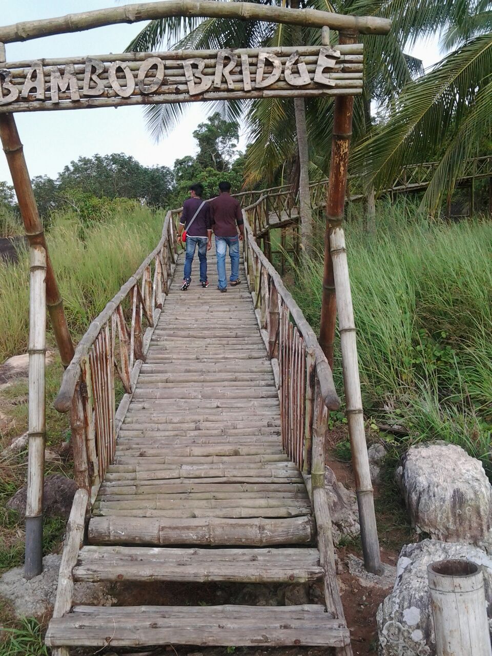
The lone Madavoorpara cave is located amidst rubber plantations and hence less explored destination till recent past. The local media, state tourism and the State Archaeological Department have initiated steps to attract tourists and locals. A small park and a 101 mt long bamboo bridge have been formed by he State Archaeological Department. The panoramic view from atop the hillock is an amazing experience.
'Ganga Theertham' the holy pond receives water from the perennial stream. Shivratri is the main annual festival celebrated in this cave temple and this event attracts thousands of devotees from far and near.
How to get there?
By road: You may take the Chempazhanthi-Potherncode route to Madavoorpara from Sreekaryam. You will reach Kattayikonam after 7 km. Take note of the Madavoorpara temple sign board on your right. You can also take the alternate route i.e., Powdikonam-Pothencode route from Sreekaryam. Drive 8 km to reach Santhipuram and divert left turn and proceed 2 km further to reach the site. There is an advantage of preferring this route i.e., you don't have to climb up the rock.
Nearest Railway station: Kazhakuttam Railway station , Kaniyapuram Railway station are the very nearby railway stations to Madavoorpara. However Thiruvananthapuram Central Railway station is city railway station.
Reference
- Madavoorpara Cave Temple http://www.techmodi.com/demo/mygod/temples/MTcw/temples_detail
Madavoorpara Siva Temple. C.P.R. Environmental Education Centre, Chennai - Paliyam Copper Plate. Kerala culture.org
- Rock of Ages The Hindu March 27, 2015
- Sunday visit to Madavoorpara Rock cut temple in Trivandrum. Travelogues of a Compulsive Roamer (http://ranjithsudhakaran.blogspot.in/)
- Temples of Thiruvananthapuram. Kerala Windows.net (http://www.keralawindow.net/templesoftrivandrum.htm)
YouTube
Madavoorpara Tourism. Madavoorpara Rock Cut Temple. Kattaikonam, Chenkottukonam, Trivandrum by Video Strawberry
Friday, September 2, 2016
Kottukal Cave: Hindu Rock cut Cave Temple, Kottukal near Kollam

Kottukal (കോട്ടക്കല്) rock cut cave, also known as Kaltrikkovil (കാലത്തിരിക്കോവിൽ) in Malayalam, is located in Ittiva (ഇട്ടിവ) village in Chadayamangalam (സദായമനഗലം) taluk in Kollam (കൊല്ലം) district, Kerala State, India PIN 691534. Ittiva village, part of Ittiva village panchayat, is in the border of the Kollam and Thiruvananthapuram (തിരുവനന്തപുരം) districts. This cave is located on the Thiruvananthapuram – Kottayam MC Road. The geographical coordinates of Ittiva are 8.8421200° North (Latitude) 76.864440° East (Longitude). It has an average elevation of 52 m (170 ft).
The name Kottukkal means carved rock in English (കൊട്ടിയ കല്ല് Kottiya Kallu in Malayalam). Kottukal rock cut cave architecture typifies rock cut cave style of Kerala. The cave hewn out from a natural living hammock situated amidst paddy field. The hillock looks like an elephant in a sitting position.
Architecture
The rock cut cave complex has two caves of uneven size. Both the caves are facing east. The larger cave has an almost square sanctum and pillared mukha-mandapam (rectangular hall). The rock cut façade has two massive supporting pillars. The smaller cave opens an oblong sanctum and there is no pillared mandapam. The cave-temple dedicated to Shiva. The sanctums have the monolithic Shiva lingams and the celestial bull (Nandi) idol. Another sanctum (niche) houses the image of sthanaka Hanuman (Anjaneya), the monkey god. In between the two caves there is a rectangular alcove like shrine housing the bas relief image of Lord Ganapathy (Lord Pillaiyar). The cave temple complex also known for its well that never dries up.
History
History
Since the rock cut cave houses three deities Lord Shiva, Lord Ganapathy and Lord Hanuman, the name "Thrikovil" emerges. The rare association of Shiva Lingam, Nandhi and Anjaneya is seen only Kottukal and nowhere else in India such combination exists. According to some scholars the cave datable between 6th and 8th centuries A.D. Some other historians assign the date back to 7th century A.D. Chadayamangalam named in remembrance of Nedila Paranthaka Nedumchadayan, who ruled Chadayamangalam between 6th and 7th century AD.
The rock cut cave temple is administered by Travancore Devaswom Board and this body conducts daily pooja services. The state government of Kerala pronounced the Kottukal cave owned by Travancore Devaswom Board as the protected monument in 1966.
How to get there?
- Best Time to visit: December to May
- Distance: Kottukal Rock cut Cave is located 10 km from Chadayamangalam and 8 km from Anchal. The place is 45 km away from Kollam and 65 km away from Tiruvananthapuram.
- Nearest Bus stations; The village is connected through local bus service from Chadayamangalam and Anchal.
- Nearest railway station: No railway station near to Ittiva in less than 10 km. Kollam (Quilon) Jn Rail Way Station is located 38 km away from Ittiva. Punalur station 19 km; Thenmalai 23 km; Ottakkal 22 km.
- Nearest airport: Trivandrum International Airport, about 60 km
Reference
- Kottukkal Rock Cave Temple GUHA Kshethram. Facebook. May 8, 2015
- Kottukal Rock Cut Cave Temple. Mahrubhumi (English). May 31, 2008
- Kottukal Rock Cut Cave Temple. Tapioca.co.in
- The Cave Temple at Kottukal, Kollam. Kerala Tourism.org
- കോട്ടുക്കല് ഗുഹാക്ഷേത്രം , അഞ്ചല്, കൊല്ലം (http://kudukka.com/coin123)
YouTube
Kottukkal cave temple by santhosh kottukkal
Kottukkal cave temple by santhosh kottukkal
Tuesday, August 30, 2016
Akkanna Madanna Caves: Hindu Rock cut Cave Temple at Vijayawada


.JPG)

.JPG)
Two east facing rock cut caves are located right at the footsteps of Indrakeeladri hills Vijayawada, Krishna District, Andhra Pradesh, India PIN 520010. The geographical coordinates of Indrakeeladri are 16°30'49" North (Latitude) ,80°36'23" East (Longitude) . It has an average elevation of 39 ft from sea level. The famous Kanaka Durga Temple is located on top of Indrakeeladri hill, on the banks of holy river Krishna, Lower cave is located at the foot hills of the old foot-path route with narrow steps leading to the to Kanaka Durga shrine. Upper cave, datable to 2nd century B.C., is located in the middle of the footpath,. According to archaeologists, the lower cave was hewn by the kings of Vishnukundinas. The caves are protected by Archaeological Survey of India (ASI).
Lower Cave
The triple celled lower rock cut cave hewn out on the face of the large living rock. The cave measures 14.63 in (48 feet) in length; 8.83 m (29 feet) in width and 2.13 m (7 feet) in height. The entirely rock cut cave comprise three almost square shaped sanctum cells hewn at the rear wall of the cave, an ardha mandapam (small rectangular pillared hall), a mukha-mandapam (slightly spacious rectangular pillared hall), all in single axial plane. The wide facade is cut from the face of the rock and supported by six robust and octagonal pillars without decoration. There are seven inter-spaces (anganas) between pillars and the entrance to the cave through the middle inter-space (angana). The structural beams (uttara) form top most section of the pillars. The column beam corbel method of architecture i,e., angular potikas (corbel brackets), usually inserted between beams and pillars as the supporting element, is absent here. The rough rock brow is bereft of any kapota (overhanging cornice) or drip line for rainwater. Another row of six octagonal pillars divide the inner cave into mukha-mandapam and ardha mandapam. The rear wall of the cave opens with three cells or sanctums.
The lower cave is sculpted about 1.5 m (5 feet) above the ground level and forming an open platform. The decorative elements of adhishtana (plinth) are not distinct. A flight of five step staircase in middle of the cave with carved balustrades on either sides leads us to the plinth platform.
It is learnt that this cave was hewn on the solid rock face by Eastern Chalukyas some time between 6th and 7th century A.D. The lower cave is believed to be dedicated to Akkanna and Madanna. the two brothers who rose to prominence in the sultanate of Golkonda between 1674 and 1685. The smarta brahmin brothers were the prime minister and the commander in chief of Qutub Shahi army, respectively in the court of Abdul Hassan Tanashah, the last ruler of the Qutub Shahi dynasty. They were the simple courtiers in their early life and later rose to the higher posts in Golconda due to their ability.
However the ASI officials of Indrakeeladri state that there is no evidence to prove the relationship between the Indrakeeladri caves and Akkanna and Madanna. The locals might have preferred to dedicate the cave to Akkanna and Madanna in recent years.
Upper Cave
The triple celled rock cut cave is believed to be dedicated to the triumvirate – Brahma, Vishnu and Shiva of the Hindu pantheon. Three different cave cells are excavated in a row on the rockface of the long sloping hillock. An unfinished rock cut cave, located in the middle, comprise a pillared ardha mandapam and almost square shaped inner sanctum. The entrance porch is enclosed by a parapet. The ardha-mandapam supported by two round (vratta sthamba) and massive pillars. The major attraction is the ancient bas relief image of Lord Vinayaga (Pillaiyar) panel carved at the left wall niche of the ardha mandapam.. Once the sanctum was housing Shiva Lingam as well as Brahma and Vishnu images. At present you could witness only pedestal with socket in the sanctum. Two cave cells (chambers) are located on either side of the slopes of the hillock and the rock face also depicts bas relief images of animals.
On either side of the cave cell, there are two single cave cells (chambers) located on either side. These two cave cells don't have pillared mandapam. It straight away has the sanctum cell. Some scholars fix the date of this cave to 2nd fcentury B.C.
On either side of the cave cell, there are two single cave cells (chambers) located on either side. These two cave cells don't have pillared mandapam. It straight away has the sanctum cell. Some scholars fix the date of this cave to 2nd fcentury B.C.
Viharas or monasteries (residences of Buddhist monks) and chaityas (cave shrines) excavated from single rocks are found in Ajanta and Ellora as well as in other parts of India. According to Shri. V.V.Krishna Sastry, former director of Indian archaeology department, the Buddhist viharas or monasteries were converted into Hindu shrines during the reign of Reddy kingdom (1325–1448 A.D.). Later several South Indian Hindu rulers patronized numerous cave shrines dedicated to gods and goddesses of Hindu pantheon. Akkanna Madanna caves could have been converted into Shaivite sanctums.
Reference
- A Testimony to the Times. P.Sujatha Varma. The Hindu January 4, 2008.
- Akkanna Madanna Rock cut cave Temple. History - An Unsolved Mystery. Facebook (https://www.facebook.com/permalink.php?story_fbid=1753501448211391&id=1531388867089318)
- Akkanna and Mandanna, Ministers of the Golconda Sultans. Indanetzone.
- Akkanna and Mandanna of Colconda were victims of Hindu. Dr.Prabhakar Rao's blog. November 29, 2009.
- Akkanna and Madanna (Wikipedia)
- Temples around Kanaka Durga Temple. Blessings on the Net.
YouTube Vijayawada-Akkanna,Madanna Caves on Indrakeeladri-Position as on 18.07.2016 by Nag Ganta
Subscribe to:
Posts (Atom)