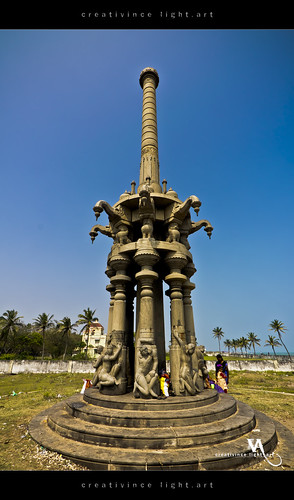
.jpg)
Muziris (Malayalam: മുച്ചിരി) or Muciri (Tamil, முசிறி) also called various names from ancient times, Mahodayapuram (Malayalam: മാക്കോതയാപുരം) (Tamil: மகோதயபுரம்), Makotai (Malayalam: മകോതൈ) (Tamil: மகோதை), Muyirikode (Malayalam: മുയിർക്കോട്) (Tamil: முயிர்க்கோடு), was an ancient seaport and urban center on the West Coast. The Sea submerged the flourishing port town Muziris at the mouth of the river Periyar (Malayalam: പെരിയാര്) (Tamil: பேரியாறு), overlooking the Arabian sea, and at present the Muziris Heritage Site (MHS) straddles across the borders of Ernakulam (North Paravur municipality) and Thrissur districts (Kodungallur municipality) of central Kerala. The historic towns of Kodungallur (Malayalam കൊടുങ്ങല്ലൂര്) (Tamil: கொடுங்களூர்), Pattanam (Malayalam: പട്ടണം) (Tamil: பட்டணம்) and Paravur (Malayalam: പറവൂർ) (Tamil: பரவூர்), forming part of MHS, are located at the hinterland, the Periyar Basin. Cherai Beach, in the MHS project area, is a major tourist destination.
 |
| PC Historum.com |
Pattanam (Malayalam: പട്ടണം), is a small village situated in the Periyar river delta in Paravur taluk, Eranakulam district, Kerala state, India PIN 683 522. It is located 1 km from Vadakkekara, 5 km from north of Paravur, 9 km south of Kodungallur (Cranganore), 25 km north of Kochi (Cochin), 28 km towards north from district head quarters Kakkanad. and 236 km from State capital Thiruvananthapuram. Pattanam lies on the geographical coordinates of 10.15654°N and 76.208982°E and the elevation / altitude is 12 m above sea level. Pattanam is currently identified by Prof. P.J. Cherian, Director of the Pattanam excavations as Muziris. Some scholars contradict this view. Ancient Tamil Sangam literature assigns it as Muciri.
Kodungallur (Malayalam കൊടുങ്ങല്ലൂര്) (anglicised name: Cranganore), a municipal town, is located in the south-west border of Thrissur district, Kerala, India PIN 680664. Kodungallur lies on the geographical coordinates of 10.233761°N and 76.194634°E and the elevation / altitude is 9 m above sea level. According to A Sreedhara Menon, the author of the title 'A Survey of Kerala History,' Kodungallur is the ancient Muziris. but no evidence of maritime or mercantile activity could be found there. About 5000 years ago Kodungallur and Paravur were part of the sea and the radiocarbon dating of peat samples prove this hypothesis. The temple at Kodungallur is conceived to have been built by Chera king Senguttuvan (சேரன் செங்குட்டுவன்), for Kannagi (கண்ணகி), heroine of Silappadikaram (சிலப்பதிகாரம்). It is believed that Kannagi gained her ascension in Kodungallur and therefore she has been enshrined here.
Muziris or Muciri (முசிறி)
Indian west coast had numerous ports when compared with Indian east coast. The reason for concentration of ports in west coast could be that they were easily approached by the traders of Roman empire. Muciri (முசிறி), an ancient port town, is popular among the port towns in the west coast (Chera country). Greeks or Yavanas called this port as Muziris. Muziris means cleft lip and the coastline resembles as the cleft lip from aerial view. Valmiki Ramayana mentions this port as 'Murasi (முரசி).' Like the internationally renowned Kaveripoompattinam in the east coast, Muciri was also far-famed for overseas trade in the west coast.
Here lies the thriving town of Muciri, where “the beautiful vessels, the masterpieces of the Yavanas (Greeks), stir white foam on the Periyar, river of Kerala, arriving with gold and departing with pepper.” (Akananuru 149:9-11).
The Pandyan port city of Korkai was the center of the pearl trade. The coastal town Muciri was also popular for its pearls. The pearl fishery was popular occupation in Periyar river estuary. Chanakya (Kautilya) refers that Chaurneyam (Tamil: சூர்னியம்) (a kind of pearl specially found in Periyar or Churni river (Tamil: சூர்ணியாறு) was brought to North India in the 4th cent. BC. Periyar river was known as `Churni river' in Sangham poetry. According Pathirruparru, the pearls of Muciri were sold in a port known as Bandhar (பந்தர்) and rare gold jewels were sold in another port called Kodumanam (கொடுமணம்). Bandhar is an Arabic term which means market place. The term stands as evidence for Arab trade links in Muciri.


Periplus of the Erythraean Sea mentions Kerala as "Cerobothra" and also provides an account on this ancient port: ”Muziris "abounds in ships sent there with cargoes from Arabia, and by the Greeks; it is located on a river, distant from Tyndis by river and sea 500 stadia, and up the river from the shore 20 stadia"... "There is exported pepper, which is produced in only one region near these markets, a district called Cottonara."
The handbook refer "Musiri, a city at the height of prosperity, was two miles distance from the mouth of the river on which it is situated and was the seat of the Government of the Kingdom under the sway of Kaprobothras." It also bring out how this coastal town became the key trade port for the Chera land. The merchant ships frequented from Roman empire as well as northern India and the settlement of the overseas traders in Muziris showed keen interest in promoting foreign trade. The warehouses stacked black pepper brought from Chera hinterland and awaited for the export opportunities through Roman traders. The shallow waters of Muziris port disallowed foreign vessels with deep hull from sailing upstream to the port. The overseas freighters were constrained to stay at the border of the lagoon. Therefore their consignments were shifted upstream on light boats.
Pliny the Elder's Natural History
Pliny the Elder (Gaius Plinius Secundus), a Roman author, naturalist, and natural philosopher, as well as naval and army commander of the early Roman Empire, published Naturalis Historia (Natural History), a comprehensive work in Latin, It is encyclopedic in scope and considered as the unique voluminous treatise survived from the Roman empire to the modern world It intents to disseminate all ancient knowledge to the modern world. According to Pliny's Natural History, Muziris is described as “the first emporium of India”, “not to be sought because of pirates nearby." and "the station for ships is at a distance from the shore and cargoes have to be landed and shipped by means of little boats. There reigned there, when I wrote this, Coelobothros". Pliny calls Kerala as "Caelobothras."
Peutinger Map (Tabula Peutingeriana)
Peutinger Map (Tabula Peutingeriana) is an odd sized medieval copy of an ancient road map. The map dates back to second century AD. In this map Muziris and Tondi ports are well indicated. The map also shows a large lake behind Muziris. It also marks the presence of Temple Augustus (Templ(um) Augusti).
Muziris Devasted by Cataclysmic Event
It is assumed that Muciri and its famous port were devastated by cataclysmic event (கடல் கோள்) in 1341 and consequently lost its commercial importance thereafter.. The apocalyptic calamities may be due to Tsunami, sea incursions, erosion and flood in Periyar river. As a result the geography of the region was altered. According to Dick Whittakker and Rajan Gurukkal, who made a study and published a document titled "In Search of Muziris," the cataclysmic event geographically altered the access to Periyar river. It not only formed Vembanad back water system but also opened up the Kochi (Cochin) harbour. The regional geological survey of the region reveals that before 200 - 300 years the shoreline was laid about 3 km east to the present coast. It could have moved even further east say about 6.5 km before 2000 years. At present Muciri region is identified and earmarked as Muziris Heritage Site (MHS) and historic towns of Kodungallur, Pattanam and North Paravur forming part of MHS.
Kodungallur (Malayalam കൊടുങ്ങല്ലൂര്) (anglicised name: Cranganore), a municipal town, is located in the south-west border of Thrissur district, Kerala, India PIN 680664. Kodungallur lies on the geographical coordinates of 10.233761°N and 76.194634°E and the elevation / altitude is 9 m above sea level. According to A Sreedhara Menon, the author of the title 'A Survey of Kerala History,' Kodungallur is the ancient Muziris. but no evidence of maritime or mercantile activity could be found there. About 5000 years ago Kodungallur and Paravur were part of the sea and the radiocarbon dating of peat samples prove this hypothesis. The temple at Kodungallur is conceived to have been built by Chera king Senguttuvan (சேரன் செங்குட்டுவன்), for Kannagi (கண்ணகி), heroine of Silappadikaram (சிலப்பதிகாரம்). It is believed that Kannagi gained her ascension in Kodungallur and therefore she has been enshrined here.
Early Cheras (Samgam Period) 270 BC - 710 AD
Chera dynasty (சேர வம்சம்), an ancient Dravidian dynasty of Tamil descent, that ruled parts of the present-day states of Kerala and Tamil Nadu. The earliest stone inscription with a reference on "Kerala" is the "Edicts of Ashoka" (BC 274-237). Kerala is mentioned as "Keralaputho" (Malayalam: കേരളപുതോ) (Tamil: கேரளபுதோ) (Kerala Puthra meaning Cheraman) in the second and thirteenth Ashoka Sthambhas. Few Tamil Brahmi inscriptions mention some Sangam Era kings: Neduncheliyan in Mangulam inscription, Athiyaman in Jambai inscription, and Irumporai dynasty in Pugalur inscription. The inscription discovered in Aranattarmalai (Tamil: ஆறுநாட்டாமலை, புகலூர்), near Pugalur in Karur district, Tamil Nadu refers to three generations of Chera rulers Ko Adan Cel Irrumporai (Tamil: கோ ஆதன் செல் இரும்பொறை), his son Perumkadunkon (Tamil: பெருங்கடுங்கோன்), and his son Ilamkadungo (Tamil: இளங்கடுங்கோ):
Patirruppattu (பதிற்றுப்பத்து), also known as Pathirruppaththu (the ten sets of ten poems), is one of the works of the Eight Anthologies or books of the Ettuttokai (எட்டுத்தொகை). The anthology consists of one hundred verses. The first and the last ten poems have been lost beyond recovery. The poems are composed by various Tamil Sangam poets. The poems glorify the affluence of ten kings of the Chera dynasty from Uthiyan Cheralathan (உதியன் சேரலாதன்) a.k.a "Perum Chorru Udiyan" (பெருஞ்சோற்று உதியன்) to Perunceral Irumporai (பெருஞ்சேரல் இரும்பொறை).
‘மூதா அமண்ணன் யாற்றூர் செங்காயபன் உறைய்ய
கோ ஆதன் செல்லிரும்பொறை மகன்
பெருங்கடுங்கோன் மகன் இளங்
கடுங்கோ இளங்கோ ஆக அறுத்த கல்’
(Aranattarmalai Inscription, near Pugalur in Karur district)
செல்வக்கடுங்கோ வாழியாதன் (Patirruppattu 7th set of Ten Poems பதிற்றுப்பத்து 7ஆம் பத்து),
பெருஞ்சேரல் இரும்பொறை (Patirruppattu 8th set of Ten Poems பதிற்றுப்பத்து 8ஆம் பத்து),
இளஞ்சேரல் இரும்பொறை (Patirruppattu 9th set of Ten Poems பதிற்றுப்பத்து 9ஆம் பத்து)
It also refers to ‘Pon Vaanigan,’ gold merchant from Karur (Tamil Nadu). The date assignable to the inscription (based on its paleography) to the first-second century A.D.
Cheras are referred to as Cherala (சேரல) and Cheraman (சேரமான்) in Sangam literature and it vaguely describes a long line of Chera rulers. It records the names of the kings, the princes, and the court poets who extolled them. However their dating is clearly absent and genealogy is lacking. The term "Kerala" never occurred in Sangam works.
 |
| PC Tamil and Vedas Blog |
Vanchi (வஞ்சி)
Vanchi (Tamil: வஞ்சி) also known as Vanchi Muthur (வஞ்சி மூதூர்) was the capital of Chera dynasty (சேரர் வம்சம்). Archaeological evidence attest that Vanchi lies in the outskirts of present day Kodungallur and some historians contradict this view. Few historians also recognize Vanchi as Karur (கரூர்) located on the banks of Amaravathi river, the ancient capital city of the Cheras, in present-day Karur district, Tamil Nadu state.
Vanchi (Tamil: வஞ்சி) also known as Vanchi Muthur (வஞ்சி மூதூர்) was the capital of Chera dynasty (சேரர் வம்சம்). Archaeological evidence attest that Vanchi lies in the outskirts of present day Kodungallur and some historians contradict this view. Few historians also recognize Vanchi as Karur (கரூர்) located on the banks of Amaravathi river, the ancient capital city of the Cheras, in present-day Karur district, Tamil Nadu state.
குடபுலங் காவலர் மருமா னொன்னார்
வடபுல விமயத்து வாங்குவிற் பொறித்த
எழுவுறழ் திணிதோ ளியறேர்க் குட்டுவண்
வருபுனல்வாயில் வஞ்சியும் வறிதே யதாஅன்று . .
(Sirupanarruppatai சிறுபணாற்றுப்படை 47 - 50)
Sirupanarruppatai (சிறுபாணாற்றுப்படை), a Sangam anthology, speaks about Cheran Kuttuvan's (சேரன் குட்டுவன்) expedition to Himalayas and imprinting the Chera's royal emblem i.e., bow and arrow on the face of the Himalaya. It also describes about the Chera capital Vanchi.
.'துஞ்சா முழவின் மூதூர் வாயில் '
(Pathirruppaththu பதிற்றுப்பத்து 236)
(Uniterrupted beat of the drum is heard in the entrance of the town)
In Silappadikaram (சிலப்பதிகாரம்), the Tamil epic composed by Ilango Adigal (இளங்கோ அடிகள்) in the 2nd century AD, a part is devoted on Vanchi town, the capital of Cheras and named as Vanchikandam (வஞ்சிக்காண்டம்), Vanchi Part or third part of the book.
‘ வஞ்சி மூதூர் மணிமண் டபத்திடை' (Amidst the temple mandapam of Vanchi Muthur town)
(Silappadikaram Varantharu Kadhai 173-174)
மண்ணகம் நிழல் செய,
மற வாள் ஏந்திய,
நிலம் தரு திருவின் நெடியோன்-தனாது
வலம் படு சிறப்பின் வஞ்சி மூதூர்
(Silappadikaram Nadukar Kadhai நடுகற்காதை 1 - 4)
முறைமையின் இந்த மூதூர் அகத்தே
அவ்வவர் சமயத்தறிபொருள் கேட்டு
மெய்வகை இன்மை நினக்கே விளங்கிய
பின்னர்ப் பெரியோன் பிடக நெறி கடவாய்
(Manimekalai Vanchi Manakar Pukka Kadhai (வஞ்சிமா நகர் புக்க காதை) 63 - 65)
· Vanchi (Tinospora Cardifolia) (Tamil: சீந்தில் கொடி) is a kind plant found in India. Kapilar (கபிலர்), the author of Kurinjippattu (குறிஞ்சிப்பாட்டு), a sangam anthology, had mentioned 99 flowers found in the Kurunji region (Mountainous region). Vanchi flower is mentioned as the 79th flower in this list. The Tamil kings and chieftains wore different flowers in the battlefield to denote different heroic activities. While invading an enemy's territory the soldiers wore Vanchi' flowers and enter in to the territory for cattle raids..
P Periyapuranam (பெரிய புராணம்) also known as Tirutontarpuranam, is the 13th century great purana or Tamil epic , depicts the legendary lives of 63 Saivite saints (Nayanmars). Kalarrarivar Nayanar Puranam (கழறிற்றறிவார் நாயனார்), (Puranam 47) mentions Vanchi as Tiruvanchaikkalam (திருவஞ்சைக்களம்) and Kodungallur (கொடுங்களூர்). The epic also describes about the fort walls and gardens.
Muziris or Muciri (முசிறி)
Indian west coast had numerous ports when compared with Indian east coast. The reason for concentration of ports in west coast could be that they were easily approached by the traders of Roman empire. Muciri (முசிறி), an ancient port town, is popular among the port towns in the west coast (Chera country). Greeks or Yavanas called this port as Muziris. Muziris means cleft lip and the coastline resembles as the cleft lip from aerial view. Valmiki Ramayana mentions this port as 'Murasi (முரசி).' Like the internationally renowned Kaveripoompattinam in the east coast, Muciri was also far-famed for overseas trade in the west coast.
மலைத் தாரமும் கடல் தாரமும்
தலைப் பெய்து, வருநர்க்கு ஈயும்
புனலங் கள்ளின் பொலந்தார்க் குட்டுவன்
முழங்கு கடல் முழவின் முசிறி யன்ன,
Purananuru புறநானுறு 343, 7-10
தலைப் பெய்து, வருநர்க்கு ஈயும்
புனலங் கள்ளின் பொலந்தார்க் குட்டுவன்
முழங்கு கடல் முழவின் முசிறி யன்ன,
Purananuru புறநானுறு 343, 7-10
Poet Paranar describes natural wealth of Muciri in Purananuru Poem 343, 7-10: "With its streets, its houses, its covered fishing boats, where they sell fish, where they pile up rice-with the shifting and mingling crowd of a boisterous river-bank were the sacks of pepper are heaped up-with its gold deliveries, carried by the ocean-going ships and brought to the river bank by local boats, the city of the gold-collared Kuttuvan (Chera chief), the city that bestows wealth to its visitors indiscriminately, and the merchants of the mountains, and the merchants of the sea, the city where liquor abounds, yes, this Muciri, were the rumbling ocean roars, is give to me like a marvel, a treasure. ."
The Chera country (Kerala) often referred to as the "Spice Garden of India" or the land of spices and this spicy commodity have an effect upon socio - geopolitics of the world. Pepper also pushed the port town onto the center-stage. The Indo - Roman trade commence in first century BC following the reign of Augustus and his conquest of Egypt. The Romans sailed to India with 'amphorae of olive oil and wines, chests of gold and silver and their famed pottery.' They established trading settlements in Chera land. In the first century BC Muziris was one of India’s most important trading ports, whose exports – especially black pepper – kept even mighty Rome in debt.
மீன் நொடுத்து நெல் குவைஇ
மிசை யம்பியின் மனைமறுக் குந்து!
மனைக் கவைஇய கறிமூ டையால்.
கலிச் சும்மைய கரைகலக் குறுந்து
கலந் தந்த பொற் பரிசம்
Purananuru புறநானுறு 343, 1-5
During Sangam era most trade was by barter. Paddy was the most popular commodity and the well accepted medium of exchange. They also exchanged purified salt. honey and roots against fish liver oil and arrack. According to Purananuru, the boat sail on the river with loads of fish and would return with paddy exchanged against fish. It seems that Muziris was a shallow port and hence the ships anchored far off from the shore. The boats with loads of pepper bags would sail towards the anchored ships to exchange gold jewels brought through ships by overseas traders.
‘சுள்ளியம் பேர்யாற்று வெண்ணுரை கலங்க
யவனர் தந்த வினைமாண் நன்கலம்
பொன்னொடு வந்து கறியொடு பெயரும்
வளங்கெழு முசிறி
(Akananuru அகநானூறு, 149:9-11)
Here lies the thriving town of Muciri, where “the beautiful vessels, the masterpieces of the Yavanas (Greeks), stir white foam on the Periyar, river of Kerala, arriving with gold and departing with pepper.” (Akananuru 149:9-11).
The Pandyan port city of Korkai was the center of the pearl trade. The coastal town Muciri was also popular for its pearls. The pearl fishery was popular occupation in Periyar river estuary. Chanakya (Kautilya) refers that Chaurneyam (Tamil: சூர்னியம்) (a kind of pearl specially found in Periyar or Churni river (Tamil: சூர்ணியாறு) was brought to North India in the 4th cent. BC. Periyar river was known as `Churni river' in Sangham poetry. According Pathirruparru, the pearls of Muciri were sold in a port known as Bandhar (பந்தர்) and rare gold jewels were sold in another port called Kodumanam (கொடுமணம்). Bandhar is an Arabic term which means market place. The term stands as evidence for Arab trade links in Muciri.
இன்னிசைப் புணரி இரங்கும் பௌவத்து
நன்கல வெறுக்கை துஞ்சும் பந்தர்க்
கமழுந தாழைக் கானலம் பெருந்துறை
(Pathirruppaththu பதிற்றுப்பத்து 6th set of 10, 5th Poem)
‘கொடுமணம் பட்ட வினைமான் அருங்கலம்
பந்தர்ப் பயந்த பலர்புகழ் முத்தம்’
Ships anchored at the port Bandhar
‘கொடுமணம் பட்ட வினைமான் அருங்கலம்
பந்தர்ப் பயந்த பலர்புகழ் முத்தம்’
(Pathirruppaththu பதிற்றுப்பத்து 8th set of 10, 4th Poem Line 5-6)
At Bandhar ornate ships brought far-famed pearls from Kodumanam
Foreign Records on Muziris
Periplus of the Erythraean Sea
Foreign Records on Muziris
Periplus of the Erythraean Sea
 |
| PC Historic Alleys |


Hippalus, a Yavana (Greek) navigator and overseas trader, is believed to be the captain of the Greek explorer Eudoxus of Cyzicus' ship. The Periplus of the Erythraean Sea (Periplus Maris Erythraei) also known as the Periplus of the Red Sea, is an unknown Greek periplus (merchant - mariner's handbook) devoted to new fields of geographical discovery and commercial achievement. The text describes about the navigation from Egyptian and Roman ports along the Red sea coast and others along Northeast Africa and the Sindh and South western India. The date assignable to Periplus of the Erythraean Sea is mid first century AD. This text gives credit to Hippalus for discovering the direct route from the Red Sea to India over the Indian Ocean. Hippalus seems to have plotted the scheme of the sea and arrived the correct the location of the trade ports along the west coast. In short Hippalus is credited for discovering the monsoon wind which is also named as Hippalus (the south-west monsoon wind).. The use of Hippalus' direct route helped the Greco-Roman ships in frequenting to Muziris port from the 1st century BC on wards. Muziris served as the pre-historic gateway to India. The ships sailed with loads of coral, copper, tin, lead and mirror and returned with Indian spices, silk, cotton, pearls, glass and stone beads. Pepper was preferred as the favorite commodity in Rome and hence known as 'Yavanapriya' (Tamil: யவனப் பிரியா).
The handbook refer "Musiri, a city at the height of prosperity, was two miles distance from the mouth of the river on which it is situated and was the seat of the Government of the Kingdom under the sway of Kaprobothras." It also bring out how this coastal town became the key trade port for the Chera land. The merchant ships frequented from Roman empire as well as northern India and the settlement of the overseas traders in Muziris showed keen interest in promoting foreign trade. The warehouses stacked black pepper brought from Chera hinterland and awaited for the export opportunities through Roman traders. The shallow waters of Muziris port disallowed foreign vessels with deep hull from sailing upstream to the port. The overseas freighters were constrained to stay at the border of the lagoon. Therefore their consignments were shifted upstream on light boats.
Pliny the Elder's Natural History
Papyrus Vindobonensis or Muziris papyrus
Papyrus Vindobonensis G 40822, widely known as the “Muziris papyrus,” is the most significant pieces of evidence concerned with Indo-Roman trade. This second century AD Greek papyrus contract document involves an Alexandrian trader, importer and financier. The papyrus document records particulars about the cargo consignment worth around nine million sesterces was imported from Muziris, on board a Roman merchant vessel named as Hermapollan. This document enabled the economists and lawyers to analyse international trade and overseas trade laws in depth.
 |
| Muziris, as shown in the 4th century Tabula Peutingeriana |
Peutinger Map (Tabula Peutingeriana) is an odd sized medieval copy of an ancient road map. The map dates back to second century AD. In this map Muziris and Tondi ports are well indicated. The map also shows a large lake behind Muziris. It also marks the presence of Temple Augustus (Templ(um) Augusti).
Muziris Devasted by Cataclysmic Event
It is assumed that Muciri and its famous port were devastated by cataclysmic event (கடல் கோள்) in 1341 and consequently lost its commercial importance thereafter.. The apocalyptic calamities may be due to Tsunami, sea incursions, erosion and flood in Periyar river. As a result the geography of the region was altered. According to Dick Whittakker and Rajan Gurukkal, who made a study and published a document titled "In Search of Muziris," the cataclysmic event geographically altered the access to Periyar river. It not only formed Vembanad back water system but also opened up the Kochi (Cochin) harbour. The regional geological survey of the region reveals that before 200 - 300 years the shoreline was laid about 3 km east to the present coast. It could have moved even further east say about 6.5 km before 2000 years. At present Muciri region is identified and earmarked as Muziris Heritage Site (MHS) and historic towns of Kodungallur, Pattanam and North Paravur forming part of MHS.
Muziris Archaeological Excavations
1945: Series of excavations undertaken at Kodungallur since from 1945. The teams could recover only antiquities of the 13th century or afterwards.
1969 Archaeological Survey of India (ASI) carried out an excavation in 1969 at Ceraman Parambu, 2 km north of Kodungallur. Only antiquities of the 13th and 16th century were recovered.
1983: A huge hoard of Roman coins was discovered at a site around six miles from Pattanam.
2007 - 2014: A series of pioneering excavations carried out by Kerala Council for Historical Research (KCHR, an autonomous institution) at Pattanam since from 2007
Pattanam Excavations 2007 - 2015
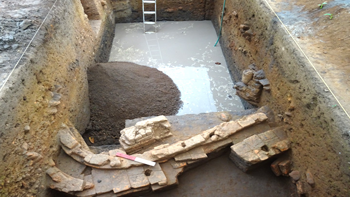
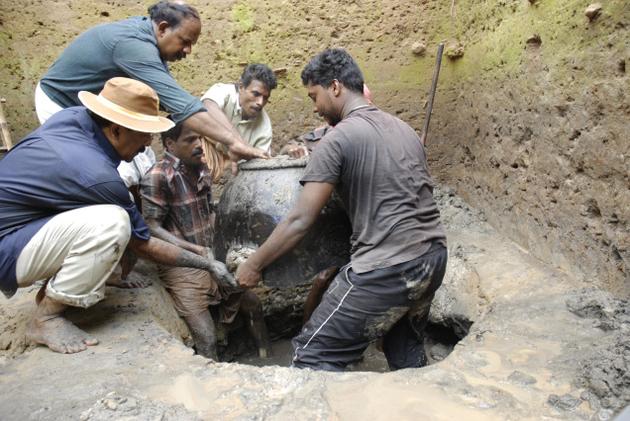
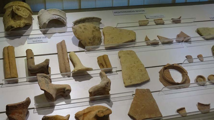
For the first time multi-disciplinary archaeological excavation was carried out by KCHR (with the approval of ASI) from 18th February to 8th April 2007 (first phase) in the historic village Pattanam. The site at Pattanam covers approximately 1.5 sq. km and the core area measures about 600 x 400 m. KCHR team carried out nine excavations (2007 - 2015) and unearthed130,865 artefacts, circa 5,16,676 diagnostic potsherds, 141, 348 non-Indian pottery sherds and circa 4.5 million local body sherds. It includes Mediterranean amphora, terra sigillata sherds, Roman glass fragments and gaming counters (dated 100 BC - 400 AD); turquoise glazed pottery, torpedo jar fragments and frankincense crumbs of West Asian, South Arabian Mesopotamian origin (dated 300 BC - 1000 AD); Chinese blue on white porcelain sherds (dated 1600 AD - 1900 AD); Local black and red ware sherds, Indian rouletted ware, gemstones, glass beads, semi precious stone beads / inlays / intaglio, cameo–blanks, coins, spices, pottery terracotta objects and human bones. They have also identified iron, copper, gold and lead objects as well as crucible slag, furnace installations, lapidary remains of semi-precious stones and spindle whorls suggesting industrial character of the settlement. Two important objects i.e., the semi precious stone carved with the figure of a pouncing lion and the micro metal object with intricate designs, were retrieved during ongoing excavations. The haul also includes 112 early coins including 3 lead coins of the Chera kingdom.
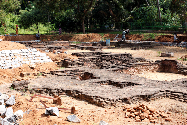
The team is surprised with the discovery of burnt bricks and roof-tiles. The remains of ancient brick wall, a brick platform, a ring well, storage jars, toilet features, lamps, stylus and scripts on pottery suggests about the existence of a prominent urban settlement and the date assigned between 100 BC and 400 AD. They have taken note of a wharf with bollards and a six meter long wooden canoe lying parallel to the wharf, about 2.5 meter below ground level.
The Institute of Physics, Bhubaneshwar carried out carbon dating and concluded that Pattanam habitation goes back to the first millennium BC. It is believed that this place was under continuous occupation from second century BC to tenth century AD. The Indo - Roman trade at Pattanam was in its peak since from first century BC.
According to Prof. PJ, Cherian, Director of the Pattanam excavations, “The discovery, in the Kerala context, has a great significance because of the dearth of evidence so far of the pre-Brahminical past of Kerala, especially in relation to the socio-cultural and religious life of the people. The KCHR team has unearthed (at a two meter depth) the Tamil Brahmi script on a pot rim, reading "a ma na" (Amana meaning a Jaina). This ancient Tamil Brahmi script with two symbols deciphered as Megalithic graffiti serves as the evident for the prevalence of Jainism on the Malabar coast at least from 2nd century AD.
1945: Series of excavations undertaken at Kodungallur since from 1945. The teams could recover only antiquities of the 13th century or afterwards.
1969 Archaeological Survey of India (ASI) carried out an excavation in 1969 at Ceraman Parambu, 2 km north of Kodungallur. Only antiquities of the 13th and 16th century were recovered.
1983: A huge hoard of Roman coins was discovered at a site around six miles from Pattanam.
2007 - 2014: A series of pioneering excavations carried out by Kerala Council for Historical Research (KCHR, an autonomous institution) at Pattanam since from 2007
Pattanam Excavations 2007 - 2015
 |
| Add caption |
 |
| Unearthing Jar PC Justkerala.in |
 |
| PC Frontline |
 |
| Pottery Feagments PC Muziris Heritage |
 |
Wharf complex Structure PC Frontline |
The Institute of Physics, Bhubaneshwar carried out carbon dating and concluded that Pattanam habitation goes back to the first millennium BC. It is believed that this place was under continuous occupation from second century BC to tenth century AD. The Indo - Roman trade at Pattanam was in its peak since from first century BC.
The Hindu march 14, 2011
|
 |
| Oxford Univ. Archaeologists @ Pattanam Excavation site PC Thulasi Kakkar |
Another pot-sherd with the Tamil-Brahmi letters reading “ur pa ve o” was deciphered by Dr. V. Selvakumar (Tamil University, Thanjavur) and Dr. K.P. Shajan (Geo-archaeologist, KCHR), the Co – Directors. Yet another another Tamil-Brahmi script with the letters “ca ta [n]” was also recovered. The exact spot of Pattanam is not clearly identified. Dr.K.P.Shajan. Shajan maintains that Periyar river had changed its course over the centuries and believes that the ancient port might have been at Pattanam. Discovery of broken pottery and ancient fired bricks during excavation suggests him the changes in the course of the river over the centuries. However historians like R Nagaswamy, KN Panikkar and MGS Narayanan have disagreed with the identification of Pattanam as Muziris and called for further research. KCHR chief maintains, "whether Pattanam was Muziris is not of immediate concern to us,"
According to Dr. Wendy Morrison of the Oxford University, the trade links of Southern India with Rome in the early Iron Age is reminiscent of the Roman invasion of England around the same period, She linked with the excavations by Oxford research team at Dorchester Village. England have come out with interesting finds on the country’s cultural and trade links with Rome. Pattanam excavations and the unearthed archaeological treasures have revolutionized the cultural history of Kerala
The Kerala State government sensed the tourism potential of the Pattanam discovery and established the Muziris Heritage Project (MHP) and the budget allocated for the first phase of the project was Rs.1,400 million. MHP envisages preservation of monuments and intends to restore old bazaars, roads, bridges, canals etc., spread across two municipal towns and 6 panchayats. The Government also sent proposal to UNESCO for declaring Muziris a world heritage site.
Reference
- Imperial Rome, Indian Ocean Regions and Muziris: New Perspectives on Maritime Trade. Mathew KS. Rouledge. 25 Nove 2015. 472p.
- Introducing the Muziris Papyrus. Maddy. Historic Alleys (http://historicalleys.blogspot.in/2010/06/introducing-muziris-papyrus.html)
- Ivory from Muziris* Federico De Romanis (http://dlib.nyu.edu/awdl/isaw/isaw-papers/8/)
- Lost cities #3 – Muziris: did black pepper cause the demise of India's ancient port? The Guardian (https://www.theguardian.com/cities/2016/aug/10/lost-cities-3-muziris-india-kerala-ancient-port-black-pepper)
- More evidence unearthed at ancient port of Muziris by A. Srivathsan. The Hindu. November 15, 2016
- Muziris Wikipedia
- Muziris, at last? Krishnakumar R. Frontline. Volume 27, Issue 08, April 10-23, 2010
- Pattanam: A Rupture in the Cultural History of Kerala. Ajaysekhar Margins. May 7th, 2011. (http://ajaysekher.net/2011/05/07/pattanam-muziris-excavations-pasts-kerala/)
- ‘Pattanam and Dorchester shared similar links with Rome’ The Hindu April 21, 2010 (http://www.thehindu.com/news/cities/Kochi/pattanam-and-dorchester-shared-similar-links-with-rome/article5933114.ece)
- Pattanam Archaeological Research. Kerala Council of Historical research.(http://kchr.ac.in/articles/87/Pattanam-Archaeological-Research.html)
- Pattanam One Five Nine (http://www.onefivenine.com/india/villages/Ernakulam/Paravur/Pattanam)
- Pattanam Wikipedia
- Periplus of the Erythraean Sea - Wikipedia
- Political History of Modern Kerala. A. Sreedhara Menon. D C Books. 1987.p. 22.
- Sangam Port: Muchiri in Kerala. Devapriya. Wordpress. March 19, 2010.
- Tamil-Brahmi script found at Pattanam in Kerala by TS.Subramaniyan. The Hindu March 14, 2011 (http://www.thehindu.com/news/national/Tamil-Brahmi-script-found-at-Pattanam-in-Kerala/article14947188.ece)
- The Ancient Roman Connections with Tamil Nadu. (https://docs.google.com/document/d/1EnoLAy1bKEITHsrWkSBMsJZEQL9nx32drsNUZ_7r5Bk/edit)
- The Chera Coins (Tamil Coins - A Study; R. Nagaswamy). Tamil Arts Academy (http://tamilartsacademy.com/books/coins/chapter01.xml)
- What is the history of the Indian city of Muziris? Yahoo Answers. (https://answers.yahoo.com/question/index?qid=20120210135734AA3geeZ)
- பண்டைத் தமிழகம் வணிகம் - நகரங்கள் மற்றும் பண்பாடு மயிலை சீனி. வேங்கடசாமி ஆய்வுக் களஞ்சியம் - 4 நியூ செஞ்சுரி புக் ஹவுஸ் பிரவேட் லிமிடெட். பக்கம் 97 - 100 (http://www.tamilvu.org/slet/ln00101/ln00101pag.jsp?bookid
- வஞ்சி, முசிறி இருப்பிடம். தமிழ்த்துளி October 13, 2014 (http://vaiyan.blogspot.in/2014/10/blog-post.html)
YouTube
